Padre Island facts for kids

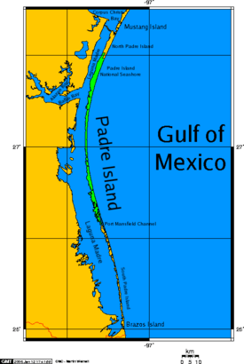
Padre Island map, showing the Laguna Madre waters enclosed along the south Texas coast.
|
|
| Geography | |
|---|---|
| Location | Gulf of Mexico |
| Coordinates | 26°50′40″N 97°22′04″W / 26.84444°N 97.36778°W |
| Area | 209 sq mi (540 km2)(31st in U.S.) |
| Length | 113 mi (182 km) |
| Width | 1.61 mi (2.59 km) |
| Coastline | 263.22 mi (423.61 km) |
| Administration | |
|
United States
|
|
| State | Texas |
| Counties | Cameron, Kenedy, Kleberg, Nueces, Willacy |
| Additional information | |
| See: North and South Padre Island | |

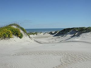
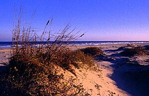
Padre Island is the biggest of the Texas barrier islands. It is also the longest barrier island in the world! This amazing island is found along the southern coast of Texas in the Gulf of Mexico. It is famous for its beautiful white sandy beaches.
The name "Padre Island" means father in Spanish. It was named after Father José Nicolás Ballí. He lived from about 1770 to 1829. Father Ballí owned the island and was a missionary priest. He also helped manage money for churches in the Rio Grande Valley.
Padre Island is the second-largest island in the contiguous United States. Only Long Island in New York is bigger. Padre Island is about 113 miles (182 km) long. It is about 1.8 miles (3 km) wide. The island stretches from the city of Corpus Christi in the north. It goes all the way to South Padre Island in the south.
The island runs from north to south. The Gulf of Mexico is on its east side. The Laguna Madre is on its west side. The northern part of the island connects to Mustang Island by a road. The southern end is separated from Brazos Island by a water channel called Brazos Santiago Pass.
The town of South Padre Island is at the southern tip. The city of Corpus Christi is at the northern end. Most of the island is not very populated. A large part of the middle of the island is a protected natural area. This area is called Padre Island National Seashore. Part of the lower island is also protected. It is part of the Laguna Atascosa National Wildlife Refuge.
Since 1964, a man-made channel called the Port Mansfield Channel has divided the island. Because of this, people often talk about "North Padre Island" and "South Padre Island". Padre Island is part of several counties in Texas. These include Cameron, Kenedy, Kleberg, Nueces, and Willacy counties.
Contents
Discovering Padre Island's Past
Long ago, the Karankawa people used Padre Island. They lived there during different seasons. This was before Europeans arrived.
During the time when Spain ruled, Father José Nicolás Ballí owned the island. This was in the 1800s. The island was known as the Isla de Santiago land grant. Father Ballí's grandfather, Nicolás Ballí, first received this land in 1759. It was given to him by King Charles III of Spain.
Father José Nicolás Ballí was a priest and missionary. He also managed large ranches on the island. In 1804, he started the first Mexican settlement on the island. It was called "El Rancho Santa Cruz de Buena Vista" (later known as Lost City).
After Mexico became independent in 1827, Father Ballí asked for clear ownership of Padre Island. He died in 1829. After his death, the government officially gave the island to him. They also gave half of it to his nephew, Juan José Ballí. His nephew had helped him with his ranch.
During World War II, scientists in the United States thought about testing the first atomic bomb on Padre Island. But they chose White Sands Missile Range in New Mexico instead.
From 1953 to 1956, a special walking race happened on the island. It was called the Padre Island Walkathon. People walked 110 miles from the south to the north end of the island. It was one of the first long-distance walking races in America. It was known as a very tough contest!
How Padre Island Was Formed
Padre Island is a young island. It formed only a few thousand years ago. It is one of about 300 barrier islands. These islands stretch from Maine to Mexico. Barrier islands are important because they protect the mainland from strong storms.
Scientists believe Padre Island started as a sandbar under the water. This was about 4,500 years ago. Over time, it grew and rose above the water. Geologists have studied how barrier islands form. They are shaped by things like sand, ocean currents, waves, and tides.
One idea is that Padre Island grew from sandbars offshore. Then, sand was added by spits. A spit is a long, narrow strip of sand. It grows out from the coastline. Over many years, storm changes and new sand helped connect smaller islands. This created the longer island we see today.
Padre Island shows how barrier islands change. They can grow, stay stable, or erode away. The northern part of Padre Island is mostly stable. But the southern part is slowly eroding. Wind, waves, and currents keep shaping the island.
Over a long time, Padre Island will likely keep eroding. This is due to less sand coming in, rising sea levels, and tropical storms. Today, hurricanes and wind blow sand into the Laguna Madre. This helps build up the island's landward side.
Amazing Wildlife of Padre Island
Padre Island is a wonderful place for animals. Many different kinds of birds and sea creatures live there.
Birds of Padre Island
Thousands of migratory birds visit Padre Island. They arrive in early spring or in the fall and winter. Some birds spend the whole winter there. Others just pass through on their long journeys. In the summer, you can see many shore and marshbirds. There are also some raptors and songbirds.
Some common birds you might see on the Gulf beach are:
- the willet
- the sanderling
- the black skimmer
- the great blue heron
- the double-crested cormorant
- the cattle egret
- the grey plover
- the laughing gull
- the brown pelican
- the reddish egret
You can also find five types of terns. These include the least tern, Caspian tern, black tern, Sandwich tern, and royal tern. The least tern and piping plover sometimes build their nests on the park's shores.
Kemp's Ridley Sea Turtle
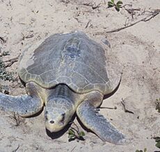
The Kemp's ridley sea turtle is a special visitor to Padre Island. These turtles are an endangered species. This means there are not many of them left in the world.
In September 2007, wildlife experts found a record number of Kemp's ridley sea turtle nests on Texas beaches. There were 128 nests in total! Eighty-one of these nests were in the Padre Island National Seashore. Four more were found on nearby Mustang Island.
Wildlife officials also released many baby Kemp's ridley turtles. In 2007, they released 10,594 hatchlings along the Texas coast. These turtles are in danger because they can get caught in shrimpers' nets. Also, in some places, they were hunted for their shells and meat. Efforts are being made to protect these amazing sea turtles.
See also
 In Spanish: Isla del Padre para niños
 | John T. Biggers |
 | Thomas Blackshear |
 | Mark Bradford |
 | Beverly Buchanan |


