
Dune facts for kids

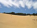
A dune is a hill of sand that is built by the wind. Sand dunes come in many different shapes and sizes. Their shape depends on how the wind blows them. An area with many sand dunes is called a "dune field." You can find sand dunes in deserts and along coasts.
Contents
Wind-Formed Dunes
Dunes formed by wind are called aeolian dunes. The word "aeolian" means "related to wind."
Shapes of Wind-Formed Dunes
Crescent-Shaped Dunes

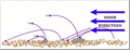
These dunes look like a crescent moon or a horseshoe. They are usually wider than they are long. The steep side of the dune faces away from the wind. These dunes form when the wind blows steadily from one direction. They are also known as barchans or transverse dunes.
Some crescent-shaped dunes can move very fast across deserts. For example, some dunes in China moved more than 100 meters (about 330 feet) in just one year! The biggest crescent dunes on Earth are in China's Taklamakan Desert.
Lunettes
Lunettes are special crescent-shaped dunes that don't move. They form on the edges of dry lakebeds or river valleys. They are made of clay, silt, sand, or gypsum. These materials are blown from the dry lakebed and pile up. Some lunettes in Australia are huge, reaching up to 6.5 kilometers (4 miles) long and 50 meters (164 feet) high.
Long, Straight Dunes

These dunes are long, straight, or slightly wavy ridges of sand. They are much longer than they are wide. Some can be over 160 kilometers (100 miles) long! They often form when winds blow from two main directions. The long part of these dunes points in the direction the sand moves most often.
Star-Shaped Dunes

Star dunes look like pyramids with three or more arms reaching out from the center. They form in places where the wind blows from many different directions. Star dunes tend to grow taller instead of spreading out. You can find many of them in the Grand Erg Oriental desert in the Sahara. Some star dunes in China's Badain Jaran Desert are incredibly tall, reaching up to 500 meters (1,640 feet)! They might be the tallest dunes on Earth.
Dome-Shaped Dunes
Dome dunes are rare. They are oval or round mounds of sand that usually don't have a steep side. They are found at the very edges of large sand areas.
U-Shaped Dunes

These dunes are U-shaped mounds of sand. They have a rounded front (nose) and long arms that trail behind. They form when wind blows away sand from an area where plants are growing. The plants hold the long arms in place. The longest arm ever found was 12 kilometers (7.5 miles) long! These dunes are also called parabolic dunes, blowout dunes, or hairpin dunes. Unlike crescent dunes, the U-shape points into the wind.
Parabolic dunes often grow in areas where there is some rain, and plants can grow. The plants, like grasses and shrubs, help to hold the trailing arms of the dune. These dunes are common in coastal deserts or near large lakes. Most parabolic dunes are not taller than a few tens of meters, except at their nose.
A special type of U-shaped dune is called a zibar. These are small, low dunes with a hard surface. They are usually less than 10 meters (33 feet) high. Zibars form at a right angle to the main wind direction. The wind blows away the fine sand, leaving behind coarser sand to form the dune crest.
Longitudinal (Seif) Dunes
_sand_dunes_imaged_by_Terra_(EOS_AM-1).jpg)
Longitudinal dunes are also called Seif dunes, which means "sword" in Arabic. They are long and narrow, running parallel to the main wind direction. They can be very tall, up to 300 meters (984 feet) high, and very long, up to 300 kilometers (186 miles)! You can find many of them in the Sahara Desert.
Seif dunes might start as crescent-shaped dunes. If the wind direction changes often, one of the "arms" of the crescent dune can grow very long, forming a seif dune.
Reversing Dunes
Reversing dunes form where winds change direction regularly. These dunes have two main steep sides that face opposite directions.
Types of Dunes: Simple, Compound, and Complex
All these dune shapes can be:
- Simple: These are basic dunes with just one main shape. They form when the wind has been steady.
- Compound: These are large dunes with smaller dunes of the same type on top of them.
- Complex: These are combinations of two or more different dune types. For example, a crescent dune might have a star dune on its crest.
Compound and complex dunes suggest that the wind's strength and direction have changed over time.
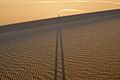
Dunes move as sand particles are blown by the wind. Sand particles can skip along the ground (called saltation) or roll (called creep). In a big dust storm, dunes can move many meters. Sand can also slide down the steep side of a dune, like a small avalanche, moving the dune forward.
Coastal Dunes
-002.JPG)
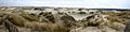
Coastal dunes form along beaches. They need a wide beach with enough sand and strong winds blowing sand inland from the sea. Obstacles like plants or pebbles slow the wind, causing sand to pile up. These small "baby dunes" grow taller if the plants also grow taller. Coastal dunes also spread sideways as coastal plants grow.
Dunes along the coast offer privacy and protection from the wind.
How Plants Grow on Coastal Dunes
As a dune forms, different types of plants grow on it over time. The conditions on a new dune are tough. There's a lot of salt from the sea, strong winds, and the sand is dry. But rotting seaweed can add nutrients.
- Pioneer plants: These are the first plants to grow, like marram grass. They have deep roots to reach water and help hold the sand together. As more sand blows over the grass, the dune grows.
- Later plants: As the grass adds nutrients to the soil, other plants like heather and gorse can grow. These plants also help to anchor the sand.
- Climax community: Eventually, the dunes might be covered by conifer trees or heathland.
Young dunes are called yellow dunes. Older dunes with more plant material are called grey dunes. In the wet, low areas between dunes, called slacks, you might find marsh plants like willow and rushes. Rare animals, like natterjack toads, sometimes breed in these slacks.
How Coastal Dune Plants Adapt
Dune environments are very hard for plants. They face challenges like:
- Little water in the soil.
- Few nutrients in the sand.
- Strong winds.
- Salt spray from the ocean.
- Shifting sand.
Plants have amazing ways to survive these conditions:
- Deep roots: Some plants have long roots to reach water deep underground.
- Spreading roots: Others have wide, shallow root systems to grab water near the surface.
- Low growth: Many plants grow low to the ground to avoid strong winds and salt spray.
- Thick leaves: Some have thick, waxy leaves to store water and reduce salt uptake.
- Pale leaves: Light-colored leaves help reflect sunlight and keep the plant cooler.
- Spiky seeds: Some seeds are spiky to help them stick in the sand and not be blown away.
Nabkha Dunes
A nabkha is a small dune that forms around a plant. These dunes often show that the land is becoming a desert or that soil is eroding. They also provide homes for animals.
Underwater Dunes

Dunes can also form underwater! These "sub-aqueous" dunes are found in rivers, estuaries, and even pipelines. They form when water currents move sand or gravel. Underwater dunes move downstream as sand is eroded from one side and deposited on the other.
These dunes often form in long chains, all similar in size. They can make it harder for water to flow, which can affect river flooding.
Hardened Dunes
A hardened (or lithified) sand dune is a type of sandstone. It forms when a sand dune, either from a desert or a beach, gets packed down and turns into rock over a very long time. Water flowing through this rock can deposit minerals, which can change the rock's color.
In the southwestern United States, hardened sand dunes are sometimes called "slickrock." Pioneers in the American Old West gave them this name because their wagon wheels couldn't get a grip on the smooth rock.
Dunes and People
Sand dunes can sometimes cause problems for people when they move into towns or farms. Dunes move because of the wind, which causes sand particles to skip, roll, or slide. In a big dust storm, dunes can move many meters.
Moving sand can threaten buildings and crops in places like Africa, the Middle East, and China. People try different ways to stop dunes from moving. One way is to plant vegetation on them, which helps to hold the sand in place. Sand fences can also slow down their movement. The United Nations Environment Programme works to prevent sand dunes from covering human areas.
Protecting Dunes

Dune habitats are home to many special plants and animals, including some rare species and endangered species. But human growth and activities like building or recreation can destroy dunes.
Many countries, including the United States, Australia, and the United Kingdom, have programs to protect dunes. They work to stabilize the sand and prevent further destruction.
Examples of Dunes Around the World
Africa
- Alexandria Coastal Dunefields, South Africa
- Witsand Nature Reserve in the Kalahari Desert, South Africa
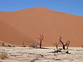
- The dunes of Sossusvlei in Namibia
- Erg Chebbi and Erg Chigaga in southern Morocco
- Grand Erg Oriental in Algeria and Tunisia
- The Great Sand Sea in Libya and Egypt
Asia
- The dunes in the Thar Desert in India and Pakistan
- Tottori Sand Dunes, Japan
- Rig-e Jenn and Rig-e Lut in Iran
- Mer'eb Dune in United Arab Emirates
- Wahiba Sands, Oman
Europe
- The Dune of Pilat, France (the largest known sand dune in Europe)
- The Dunes of Piscinas, Sardinia island, Italy
- Oxwich Dunes, Wales
- Słowiński National Park, Poland
- Råbjerg mile, Denmark
- Hoge Veluwe National Park, Netherlands
North America

.jpg)
- Great Kobuk Sand Dunes, Alaska
- The Athabasca Sand Dunes, Saskatchewan, Canada
- The Kelso Dunes in the Mojave Desert of California
- Great Sand Dunes National Park and Preserve, Colorado
- White Sands National Park, New Mexico
- Sleeping Bear Dunes National Lakeshore, Michigan
- Indiana Dunes National Park, Indiana
- Oregon Dunes National Recreation Area, Oregon
South America

- Lençóis Maranhenses National Park in Brazil
- Médanos de Coro National Park in Venezuela
- Duna Federico Kirbus in Argentina
- Cerro Blanco in Peru
Oceania
- Simpson Desert sand dunes in Australia
- Fraser Island in Australia
- Stockton Beach in Australia
- Te Paki sand dunes near Cape Reinga, New Zealand
World's Tallest Dunes
| Dune | Height from Base (feet/meters) | Height from Sea Level (feet/meters) | Location | Notes |
|---|---|---|---|---|
| Duna Federico Kirbus | ~4,035/1,230 | ~9,334/2,845 | Bolsón de Fiambalá, Fiambalá, Catamarca Province, Argentina | Believed to be the highest in the world |
| Cerro Blanco | ~3,860/1,176 | ~6,791/2,080 | Nasca Valley, Department of Ica, Peru | Highest in Peru, second highest in the world |
| Badain Jaran Dunes | ~1,640/500 | ~6,640/2,020 | Badain Jaran Desert, China | World's tallest stationary dunes and highest in Asia |
| Rig-e Yalan Dune | ~1,542/470 | ~3,117/950 | Lut Desert, Iran | Near one of the hottest places on Earth |
| Big Daddy/Dune 7 | 1,256/383 | ~1,870/570 | Sossusvlei, Namib Desert, Namibia | Often called the highest dune in the world by some sources |
| Mount Tempest | ~920/280 | ~920/280 | Moreton Island, Brisbane, Australia | Highest in Australia |
| Star Dune | >750/230 | ~8,950/2,730 | Great Sand Dunes National Park and Preserve, Colorado, USA | Highest in North America |
| Dune of Pyla | ~345/105 | ~699/130 | Bay of Arcachon, France | Highest in Europe |
| Medanoso Dune | ~1805/550 | ~5446/1,660 | Atacama Desert, Chile | Highest in Chile |
Dunes on Other Planets

Dunes can probably be found anywhere there's an atmosphere, winds, and dust. They are common on Mars and on Titan, one of Saturn's moons.
Titan's dunes are very large, sometimes 20-30 kilometers (12-18 miles) long. They are thought to be longitudinal dunes, meaning their crests are parallel to the main wind direction. The "sand" on Titan is likely made of hydrocarbon particles, possibly mixed with some water ice.
Images for kids
-
Coastal dunes in De Panne, Belgium
-
Coastal dunes at the Yyteri Beach in Pori, Finland
-
Cadiz Dunes Wilderness
-
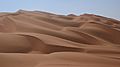
Sand dunes of the Empty Quarter to the east of Liwa Oasis, United Arab Emirates
-
Sand particles skipping along a dune (saltation). This helps dunes grow.
-
Dune Nine in Sossusvlei, Namibia, is over 300m high.
-
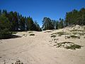
Sand dunes of Hyypänmäki in Hailuoto, Finland
-
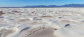
Gypsum dune fields, White Sands National Park, New Mexico, United States
-
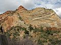
Layers in hardened sand dunes (sandstone) in Zion National Park, Utah
-
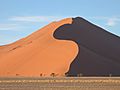
A dune in Sossusvlei, in the greater Namib-Naukluft National Park, Namibia. Notice the trees for size.
-
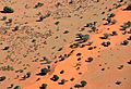
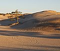
Camelthorn trees and bushes scattered on dunes in the Kalahari Desert in Namibia (2017)
-
Sand dune in the Libyan Desert near Dakhla Oasis at sunset.
-
A 50-meter (164-foot) tall dune in Salir do Porto, Portugal
-
Sand dunes of Lemnos, Greece
-
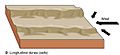
How a seif dune forms, growing parallel to the wind.
-
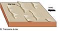
Transverse dunes form with the wind blowing across them, having one steep side.
-
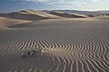
Transverse dunes move forward, creating these layered patterns inside.


.jpg)


.jpg)

.jpg)


See also
 In Spanish: Duna para niños
