
Thar Desert facts for kids
Quick facts for kids Thar DesertGreat Indian Desert |
|
|---|---|

Thar Desert in Rajasthan, India
|
|

Map of the Thar Desert ecoregion
|
|
| Ecology | |
| Realm | Indomalayan |
| Biome | Deserts and xeric shrublands |
| Borders | Northwestern thorn scrub forests and Rann of Kutch seasonal salt marsh |
| Geography | |
| Area | 238,254 km2 (91,990 sq mi) |
| Countries | India and Pakistan |
| States of India and provinces of Pakistan | India: Rajasthan, Gujarat, Haryana, Punjab, Pakistan: Punjab and Sindh |
| Coordinates | 27°N 71°E / 27°N 71°E |
| Climate type | Hot |
| Conservation | |
| Conservation status | vulnerable |
| Protected | 41,833 km2 (18%) |
The Thar Desert, also known as the Great Indian Desert, is a large dry region. It is located in the northwestern part of the Indian subcontinent. This desert covers about 200,000 square kilometers (77,000 sq mi) across India and Pakistan. It is the 18th largest desert in the world. It is also the 9th largest hot subtropical desert.
Most of the Thar Desert, about 85%, is in India. The remaining 15% is in Pakistan. In India, over 60% of the desert is in the state of Rajasthan. It also reaches into Gujarat, Punjab, and Haryana. In Pakistan, it extends into the provinces of Sindh and Punjab. The part in Pakistani Punjab is called the Cholistan Desert. To the north, west, and northeast, the desert meets the Indo-Gangetic Plain. The Rann of Kutch is to its south. The Aravali Range forms its eastern border.
Contents
Exploring the Thar Desert's Geography


The northeastern part of the Thar Desert lies between the Aravalli Hills. The desert stretches north to Punjab and Haryana. It reaches the Great Rann of Kutch along the coast. To the west and northwest, it meets the plains of the Indus River. Much of the desert has huge, shifting sand dunes. These dunes get sand from nearby plains and the coast. Strong winds before the monsoon season make the sand move a lot. The Luni River is the only river in this desert. The area gets 100 to 500 millimeters (4 to 20 inches) of rain each year. Almost all of this rain falls between June and September.
Saltwater Lakes in the Desert
The Thar Desert has several saltwater lakes. These include Sambhar, Kuchaman, Didwana, Pachpadra, and Phalodi in Rajasthan. Kharaghoda is another such lake in Gujarat. These lakes collect rainwater during the monsoon. They then dry up during the hot season. The salt in these lakes comes from the rocks in the region.
Thar Desert Climate and Weather
The climate here is dry and subtropical. Temperatures change a lot with the seasons. In winter, it can get close to freezing. In summer, temperatures can go above 50 °C (122 °F). The average yearly rainfall is 100 to 500 mm (4 to 20 inches). This rain mostly falls during the short southwest monsoon, from July to September.
The desert has two main parts. The western part, called Marusthali, is very dry. The eastern part is a semidesert. It has fewer sand dunes and gets a bit more rain.
How the Thar Desert Has Changed Over Time
The Thar Desert has changed a lot over thousands of years. Long ago, during a very cold period, a huge ice sheet covered the Tibetan Plateau. This changed weather patterns across the region. It stopped the monsoon rains from reaching the Indian subcontinent. This led to the Thar Desert growing larger.
Around 10,000 to 8,000 years ago, a river called the Ghaggar-Hakra flowed through this area. Some people believe this was the ancient Sarasvati River. This river eventually changed its path and dried up.
About 5,000 years ago, the Indus Valley Civilisation thrived here. Many ancient cities like Kalibangan and Dholavira grew along these rivers. But as the monsoon rains lessened, the rivers dried up even more. By 4,000 years ago, the great Harappan cities declined. People then lived in smaller farming communities.
Protecting the Desert from Spreading


The soil in the Thar Desert is dry for most of the year. This makes it easy for winds to blow it away. Strong winds carry soil from the desert. Some of this soil lands on fertile lands nearby. This also causes sand dunes within the desert to move. To stop this, people stabilize the sand dunes. They first build small barriers with scrub plants. Then, they plant shrubs like phog and trees like gum acacia. The 649-kilometer-long Indira Gandhi Canal brings fresh water to the Thar Desert. It was built to stop the desert from spreading into fertile areas.
Protected Natural Areas
There are several special protected areas in the Thar Desert. These places help protect the unique plants and animals.
- In India:
- The Desert National Park in Rajasthan covers 3,162 square kilometers (1,221 sq mi). It protects the Thar Desert ecosystem. It is home to animals like the great Indian bustard, blackbuck, chinkara, fox, wolf, and caracal. Ancient seashells and huge fossilized tree trunks in Akal Wood Fossil Park show the desert's long history.
- The Tal Chhapar Sanctuary is 7 square kilometers (2.7 sq mi). It is an important bird area. It is located in the Churu district of Rajasthan. This sanctuary has many blackbucks, foxes, caracals, partridges, and sand grouse.
- The Sundha Mata Conservation Reserve covers 117.49 square kilometers (45.36 sq mi). It is in the Jalore District of Rajasthan.
- In Pakistan:
- The Nara Desert Wildlife Sanctuary covers 6,300 square kilometers (2,400 sq mi). It is in Mirpurkhas District. It has the largest group of the endangered mugger crocodile in Pakistan.
- The Rann of Kutch Wildlife Sanctuary in Badin District is an important bird area. It is also a Ramsar Site. It has 30 types of mammals, 112 bird species, 20 reptiles, and 22 important plant species.
- The Lal Suhanra Biosphere Reserve and National Park is a UNESCO biosphere reserve. It covers 65,791 hectares (254.02 sq mi) in the Cholistan Desert.
Thar Desert's Amazing Biodiversity
Desert Animals and Their Life Cycle
Some wildlife species that are rare elsewhere in India thrive in the desert. These include the blackbuck (Antilope cervicapra), chinkara (Gazella bennettii), and Indian wild ass (Equus hemionus khur). They are found in large numbers in places like the Rann of Kutch. This is partly because they are well-suited to this environment. They are smaller than similar animals in other places. They are also mostly active at night. Another reason is that the grasslands here have not been turned into farms as quickly as elsewhere. Also, a local community called the Bishnois works hard to protect these animals.
Other mammals in the Thar Desert include a type of red fox (Vulpes vulpes pusilla) and the caracal. Many reptiles also live here.
The region is a safe home for 141 types of migratory and local desert birds. These include harriers, falcons, buzzards, kestrels, vultures, and different kinds of eagles.
The Indian peafowl lives and breeds in the Thar region. The peacock is India's national bird. It is also the provincial bird of Punjab (Pakistan). You can often see peacocks sitting on khejri or pipal trees in villages.
The Great Indian Bustard (Ardeotis nigriceps) is one of the world’s heaviest flying birds. It lives in the Thar Desert of Rajasthan. This bird is critically endangered. It thrives in open grasslands and semi-dry areas.
-
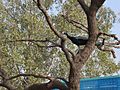
Peacock on a khejri tree
-
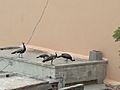
Peafowl eating pieces of chapati in Tharparkar District, Sindh
-
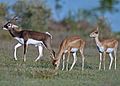
Blackbuck male and female
-
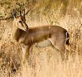
The chinkara or Indian gazelle is found across the Thar Desert.


Desert Plants and Their Reproduction
.jpg)

The natural plants in this dry area are called northwestern thorn scrub forest. This means there are small, scattered groups of green plants. These green patches become denser and larger from west to east. This happens as rainfall increases. The main plants of the Thar Desert are trees, shrubs, and perennial herb species. Some examples include Aerva javanica, Balanites roxburghii, Calotropis procera, and Capparis decidua. Common grasses include Ochthochloa compressa, Dactyloctenium scindicum, and Cenchrus biflorus.
Some plants are found only in this area. These include Calligonum polygonoides, Prosopis cineraria, Acacia nilotica, Tamarix aphylla, and Cenchrus biflorus.
A Look at the Thar Desert's History
The Desert National Park in Jaisalmer district has very old animal and plant fossils. Some are 180 million years old! The history of Jaisalmer State began with the Bhati dynasty. Their large empire once stretched from what is now Afghanistan to parts of modern-day Pakistan and India.
Over time, the Bhati rulers moved south. They eventually settled in Cholistan and Jaisalmer. Maharawal Jaisal Singh founded Jaisalmer as a new capital in 1156. The state was named after this city. In 1818, Jaisalmer became a British protectorate.
The kingdom's economy relied on taxes from caravans. But when Bombay became a major port, sea trade grew. This caused the traditional land routes to decline. The kingdom became poorer. A severe drought and famine from 1895 to 1900 caused many animals to die. This was a big problem for the farming kingdom.
In 1965 and 1971, people moved between the Indian and Pakistani parts of the Thar. Thousands of families moved to new homes.
In 2023, scientists found the remains of a new dinosaur species here. It was named Tharosaurus indicus. This plant-eating dinosaur lived in the Thar Desert during the Middle Jurassic period.


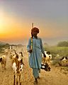
People and Life in the Thar Desert
The Thar people are the original inhabitants of this area. The Thar Desert is the most populated desert in the world. About 83 people live in each square kilometer. In India, the people include Hindus, Jains, Sikhs, and Muslims. In Pakistan, both Muslims and Hindus live here.
About 40% of all people in Rajasthan live in the Thar Desert. Most people work in farming and raising animals.
Jodhpur is the largest city in the region. It is on the edge of the desert, in a scrub forest area. Bikaner and Jaisalmer are the largest cities completely inside the desert.
-
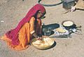
A girl from the Gadia Lohars nomadic tribe of Marwar, cooking her food.
-
Life in the Thar Desert
-
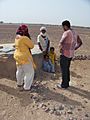
Desert tribes near Jaisalmer, India


Water and Homes in the Desert
In the driest parts of the desert, water is very scarce. The only water sources for animals and people are small ponds. Some are natural (called tobas). Others are built by people (called johads). The lack of water greatly affects life in the Thar. Many people live a nomadic lifestyle, moving from place to place. Most permanent homes are near two seasonal streams in the Karon-Jhar hills. Drinking water from underground is also rare. Much of it tastes sour because of dissolved minerals. Sweet-tasting water is usually found very deep underground. When wells are dug that find good water, people often settle nearby. But digging these wells is hard and can be dangerous.
Crowded living conditions are common in some areas.
-
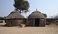
Huts in the Thar Desert
-
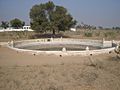
Johads are common water sources
-
Tanks for drinking water


Thar Desert's Economy and Resources
Farming in the Desert
The Thar is one of the most populated desert areas. Farming and raising animals are the main jobs for its people.
Most crops are kharif crops. These are grown in the summer season. They are planted in June and July. They are harvested in September and October. Examples include bajra, pulses like guar, jowar (Sorghum vulgare), maize (zea mays), sesame, and groundnuts.
-
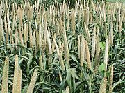
Bajra is a main summer crop in Thar.
-
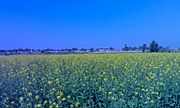
Mustard fields in a village of Shri Ganganagar district (Rajasthan, India).


Raising Animals (Livestock)
-
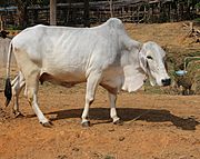
Thari cow breed from Tharparkar, Sindh. It became popular after World War I.
-
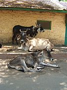
Cattle in the Thar Desert


Agroforestry: Trees and Farming

The wood from P. cineraria trees is good for fuel. Its branches are also used for fencing. The roots of this tree help the soil. They add nitrogen, which helps crops grow better.

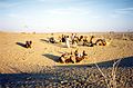
Ecotourism: Visiting the Desert
Desert safaris on camels are very popular near Jaisalmer. Tourists from India and other countries visit the desert. They enjoy camel adventures that can last from one day to several. This type of tourism helps many people. It provides income for tour operators and camel owners in Jaisalmer. It also creates jobs for camel trekkers in nearby desert villages. People also come from around the world to see the Pushkar Fair and the desert oases.
-
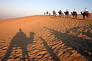
Camel ride in the Thar Desert near Jaisalmer, India
-
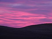
Sunrise in the desert


Industry and Energy
The Indian government started looking for oil in the Jaisalmer area in the 1950s. In 1988, Oil India Limited found natural gas in the Jaisalmer basin.
The Bhadla Solar Park is also in the Thar Desert. It covers 5,700 hectares (14,000 acres). It can produce over 2 gigawatts of solar power.
See also
 In Spanish: Desierto de Thar para niños
- Arid Forest Research Institute
- Arid Lands Information Network
- Aridification
- Cholistan Desert
- Nara desert
- Cyclone Phet – tracked directly over the desert
- Deforestation
- Geography of India
- History of Thar
- List of deserts by area
- Marwar
- Pokhran
- Thari people
