
Badin District facts for kids

Badin District (which is called ضلع بدین in Urdu) is a special area, like a county, in the Sindh province of Pakistan. It's located in the southeastern part of the Sindh province. This district is known for its farming, especially for growing rice. Many people live here, and it's an important place for the local economy.
Contents
How Badin District is Organized
Badin District is divided into smaller parts to help manage it better. Think of it like a big school divided into different classes. These smaller parts are called talukas. Each taluka has its own local government to help with things like schools, roads, and other services for the people living there.
The Talukas of Badin
Badin District has several talukas, which are:
- Badin Taluka
- Matli Taluka
- Shaheed Fazil Rahu Taluka
- Talhar Taluka
- Tando Bago Taluka
Union Councils and Villages
To make sure local services reach everyone, these talukas are further divided into even smaller areas called Union Councils. These councils help manage things at a very local level, like in villages and small towns. Badin District has 49 Union Councils. These councils then oversee even smaller areas called Tapas (109 of them) and Dehs (511 of them), which are like groups of villages or specific land areas. This system helps the government work closely with the people in every part of the district.
Images for kids
-
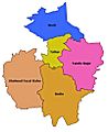
Map showing the different talukas within Badin District.

