
Haryana facts for kids
Quick facts for kids
Haryana
|
|||||||||||||||||||||||||||
|---|---|---|---|---|---|---|---|---|---|---|---|---|---|---|---|---|---|---|---|---|---|---|---|---|---|---|---|
| State of Haryana | |||||||||||||||||||||||||||
 .JPG)     From top, left to right: Cyber City in Gurgaon, Pinjore Gardens, bronze chariot of Krishna and Arjuna at Kurukshetra, Asigarh Fort, Ghaggar river, Lake in Surajkund.
|
|||||||||||||||||||||||||||
|
|||||||||||||||||||||||||||
| Etymology: Abode of God or Green Forest | |||||||||||||||||||||||||||
| Motto(s):
Satyameva Jayate
(Truth alone triumphs) |
|||||||||||||||||||||||||||

Location of Haryana in India
|
|||||||||||||||||||||||||||
| Country | |||||||||||||||||||||||||||
| Region | North India | ||||||||||||||||||||||||||
| Before was | Part of Punjab | ||||||||||||||||||||||||||
| Formation | 1 November 1966 | ||||||||||||||||||||||||||
| Capital | Chandigarh | ||||||||||||||||||||||||||
| Largest city | Faridabad | ||||||||||||||||||||||||||
| Districts | 22 (6 divisions) | ||||||||||||||||||||||||||
| Government | |||||||||||||||||||||||||||
| • Body | Government of Haryana | ||||||||||||||||||||||||||
| State Legislature | Unicameral | ||||||||||||||||||||||||||
| • Assembly | Haryana Legislative Assembly (90 seats) | ||||||||||||||||||||||||||
| National Parliament | Parliament of India | ||||||||||||||||||||||||||
| • Rajya Sabha | 5 seats | ||||||||||||||||||||||||||
| • Lok Sabha | 10 seats | ||||||||||||||||||||||||||
| High Court | Punjab and Haryana High Court | ||||||||||||||||||||||||||
| Area | |||||||||||||||||||||||||||
| • Total | 44,212 km2 (17,070 sq mi) | ||||||||||||||||||||||||||
| Area rank | 21st | ||||||||||||||||||||||||||
| Elevation | 200 m (700 ft) | ||||||||||||||||||||||||||
| Highest elevation
(Karoh Peak)
|
1,499 m (4,918 ft) | ||||||||||||||||||||||||||
| Lowest elevation | 169 m (554 ft) | ||||||||||||||||||||||||||
| Population
(2011)
|
|||||||||||||||||||||||||||
| • Total | |||||||||||||||||||||||||||
| • Rank | 18th | ||||||||||||||||||||||||||
| • Density | 573/km2 (1,480/sq mi) | ||||||||||||||||||||||||||
| • Urban | 34.88% | ||||||||||||||||||||||||||
| • Rural | 65.12% | ||||||||||||||||||||||||||
| Demonym(s) | Haryanvi | ||||||||||||||||||||||||||
| Language | |||||||||||||||||||||||||||
| • Official | Hindi | ||||||||||||||||||||||||||
| • Additional official | English and Punjabi | ||||||||||||||||||||||||||
| • Official script | Devanagari script, Gurmukhi script | ||||||||||||||||||||||||||
| GDP | |||||||||||||||||||||||||||
| • Total (2023–24) | |||||||||||||||||||||||||||
| • Rank | 13th | ||||||||||||||||||||||||||
| • Per capita | |||||||||||||||||||||||||||
| Time zone | UTC+05:30 (IST) | ||||||||||||||||||||||||||
| ISO 3166 code | IN-HR | ||||||||||||||||||||||||||
| Vehicle registration | HR | ||||||||||||||||||||||||||
| HDI (2019) | |||||||||||||||||||||||||||
| Literacy (2011) | |||||||||||||||||||||||||||
| Sex ratio (2021) | 926♀/1000 ♂ (29th) | ||||||||||||||||||||||||||
|
|||||||||||||||||||||||||||
| Joint Capital with Punjab Common for Punjab, Haryana and Chandigarh. |
|||||||||||||||||||||||||||


Haryana is a state in the northern part of India. It was created on November 1, 1966, from the former state of East Punjab. Haryana is the 21st largest state in India by area, covering less than 1.4% of the country's land.
The capital of Haryana is Chandigarh, which it shares with the nearby state of Punjab. The biggest city in Haryana is Faridabad, which is part of the National Capital Region (NCR). Gurgaon is another important city, known as a major center for finance and technology in India.
Haryana has 6 main administrative areas called divisions, 22 districts, and many smaller towns and villages. It is home to 32 special economic zones (SEZs), mostly located along important industrial routes. Gurgaon is a big hub for information technology and car manufacturing. Haryana ranks 11th among Indian states in terms of human development. Its economy is the 13th largest in India, with a total value of about 12.25 trillion Indian Rupees (INR) in 2023–24.
The state has a rich history, many monuments, and diverse plants and animals. It also has a strong economy and good road networks. Haryana shares borders with Punjab and Himachal Pradesh to the north, Rajasthan to the west and south. The Yamuna river forms its eastern border with Uttar Pradesh. Haryana surrounds Delhi, India's capital, on three sides, making a large part of the state important for economic planning and development within the NCR.
Contents
What Does the Name Haryana Mean?
Experts believe the name Haryana comes from the word Ābhirāyana. This word combines ābhira, referring to a group of people called the Ābhiras, and ayana, meaning "path" or "way." The Ābhiras lived here after the Mahabharata period and were skilled in farming. Over time, Ābhirāyana changed to Ahirāyana and then to Hariyānā, which is now Haryana. It is also thought to mean "Abode of God" or "Green Forest."
A Look at Haryana's History
Ancient Times in Haryana

The villages of Rakhigarhi and Bhirrana in Haryana are home to very old sites from the Indus Valley civilization. These sites show signs of paved roads, drainage systems, and large systems for collecting rainwater. People here were skilled in working with metal and making bricks.
During the Vedic period, Haryana was where the Kuru Kingdom was located. This was one of India's great ancient kingdoms. The southern part of Haryana is believed to be the location of Manu's state of Brahmavarta. This area was home to many wise people (Rishis) who helped create important Hindu scriptures like the Vedas and Upanishads.
Medieval Period in Haryana
Ancient statues of Jain Tirthankara (important figures in Jainism) have been found in many places across Haryana.

The Pushyabhuti dynasty ruled parts of northern India in the 7th century, with its capital at Thanesar. Harsha was a famous king from this dynasty. Later, the Tomara dynasty ruled the southern Haryana region in the 10th century. Anangpal Tomar was a well-known king among the Tomaras.
In 1398, a ruler named Timur attacked and looted many cities in Haryana, including Sirsa, Fatehabad, and Panipat. Many residents fled, and thousands were killed or taken prisoner. The Ahirs and Jats tried to fight back but were defeated.

Hem Chandra Vikramaditya, also known as Hemu, became a powerful ruler. He defeated the Mughal forces in the Battle of Delhi on October 7, 1556. He took the old title of Vikramaditya and became the last Hindu Emperor of India. He had won 22 battles before this, from 1553 to 1556.
Panipat is famous for three very important battles in Indian history:
- In the First Battle of Panipat (1526), Babur defeated the Lodis.
- In the Second Battle of Panipat (1556), Akbar defeated Hemu.
- In the Third Battle of Panipat (1761), the Afghan king Ahmad Shah Abdali defeated the Marathas.
British Rule in Haryana

During the time of British rule, Haryana was part of the Punjab province. The Delhi division of Punjab province made up most of what is now Haryana. Some smaller princely states like Jind and Loharu were also located in this area.
How Haryana Was Formed
When India was divided in 1947, the Punjab province was split between India and Pakistan. Haryana, along with other areas where Hindus and Sikhs lived, became part of India as the state of East Punjab. Many Muslims moved to Pakistan, and many Hindu and Sikh refugees came to Haryana from West Punjab.
Haryana became a separate state on November 1, 1966. The Indian government set up the Shah Commission to decide how to divide Punjab based on the languages people spoke. Haryana was formed from the parts of Punjab where people mainly spoke Hindi. The remaining area, where Punjabi speakers were the majority, became the new state of Punjab.
The commission suggested that Kharar, which includes Chandigarh, should be part of Haryana. However, Kharar was given to Punjab. Chandigarh was made a union territory, serving as the capital for both Punjab and Haryana. Bhagwat Dayal Sharma became the first Chief Minister of Haryana.
People and Languages of Haryana
Religions in Haryana
According to the 2011 census, most people in Haryana are Hindus (87.46%). The largest minority groups are Muslims (7.03%) and Sikhs (4.91%).
Muslims are mostly found in the Nuh district. Haryana has the second largest Sikh population in India after Punjab. Sikhs mainly live in districts close to Punjab, like Sirsa and Ambala.
| Religious group |
1901 | 1911 | 1921 | 1931 | 1941 | 2011 | ||||||
|---|---|---|---|---|---|---|---|---|---|---|---|---|
| Pop. | % | Pop. | % | Pop. | % | Pop. | % | Pop. | % | Pop. | % | |
| Hinduism |
3,012,101 | 70.57% | 2,644,264 | 68.32% | 2,898,119 | 68.82% | 2,980,206 | 66.29% | 3,436,411 | 66.52% | 22,171,128 | 87.46% |
| Islam |
1,090,306 | 25.54% | 1,019,439 | 26.34% | 1,074,072 | 25.5% | 1,204,537 | 26.79% | 1,401,689 | 27.13% | 1,781,342 | 7.03% |
| Sikhism |
135,634 | 3.18% | 175,837 | 4.54% | 193,075 | 4.58% | 271,077 | 6.03% | 292,487 | 5.66% | 1,243,752 | 4.91% |
| Jainism |
23,906 | 0.56% | 20,950 | 0.54% | 24,005 | 0.57% | 23,666 | 0.53% | 23,050 | 0.45% | 52,613 | 0.21% |
| Christianity |
6,232 | 0.15% | 10,019 | 0.26% | 22,075 | 0.52% | 16,228 | 0.36% | 11,549 | 0.22% | 50,353 | 0.2% |
| Zoroastrianism |
27 | 0.001% | 53 | 0.001% | 39 | 0.001% | 8 | 0.0002% | 62 | 0.001% | N/A | N/A |
| Judaism |
5 | 0.0001% | 8 | 0.0002% | 2 | 0% | 2 | 0% | 7 | 0.0001% | N/A | N/A |
| Buddhism |
0 | 0% | 4 | 0.0001% | 5 | 0.0001% | 6 | 0.0001% | 149 | 0.003% | 7,514 | 0.03% |
| Others | 11 | 0.0003% | 0 | 0% | 1 | 0% | 0 | 0% | 765 | 0.01% | 44,760 | 0.18% |
| Total Population | 4,268,222 | 100% | 3,870,574 | 100% | 4,211,393 | 100% | 4,495,730 | 100% | 5,166,169 | 100% | 25,351,462 | 100% |
Languages Spoken in Haryana
The main official language of Haryana is Hindi.
Many regional languages or dialects are spoken in the state. The most common is Haryanvi, also called Bangru. It is spoken in the central and eastern parts of Haryana. Hindi and Punjabi are spoken in the northeast. Other languages include Bagri in the west, and Mewati in the south.
Punjabi was made the second official language of Haryana in 2010 for government use. Before that, Telugu and Tamil were briefly considered second languages for teaching in schools, but they were later removed due to a lack of speakers.
Culture of Haryana
Haryana has its own special traditional folk music, folk dances, and folk theatre called saang. It also has unique beliefs like Jathera (worship of ancestors) and arts like Phulkari embroidery.
Music and Dances
The folk music and dances of Haryana often reflect the farming and brave nature of its people.
Popular forms of Haryanvi musical theatre include Saang, Rasa lila, and Ragini. The Saang and Ragini theatre styles were made popular by Lakhmi Chand.
Haryanvi folk dances and music are known for their fast and energetic movements. There are three main types of dances:
- Festive-seasonal dances: These are performed during festivals and seasons, such as Holi and Teej.
- Devotional dances: These are linked to religious practices, like Ras Leela.
- Ceremonial-recreational dances: These include dances about brave heroes (like Kissa), love stories (like Nāginī dance), and special events (like Dhamal Dance and Ghoomar).
Folk Music and Songs
Haryanvi folk music often talks about everyday life and includes humor. It has two main styles: "Classical folk music" and "Desi Folk music" (Country Music of Haryana). Songs are often sung as ballads about love, bravery, harvests, and feelings of separation.
Classical Haryanvi Folk Music
Classical Haryanvi folk music is based on Indian classical music. It uses different Hindustani classical ragas (musical scales) to sing about heroic bravery, religious worship, and festive songs for occasions like Teej and Holi. Songs about bravery are usually sung in a high pitch.
Desi Haryanvi Folk Music
Desi Haryanvi folk music is based on different Raags like Raag Bhairvi. It is used to celebrate community spirit and to sing seasonal songs, ballads, and songs for ceremonies like weddings. Songs about relationships and love are sung in a medium pitch, while ceremonial and religious songs are sung in a low pitch.
Young girls and women often sing fun, fast songs about seasons, love, and friendship. Older women usually sing devotional songs and ceremonial songs for events like weddings and childbirth.
Music's Role in Society
Music and dance help bring people together in Haryana. Folk singers are highly respected and are invited to many events, no matter their background. These songs are shared by people from different communities and can change slightly in dialect or style over time. This shows how flexible and welcoming Haryanvi culture is.
In modern cities like Gurgaon, public art and murals also show the cultural spirit of Haryana.
Food in Haryana
The food in Haryana is simple and healthy, reflecting its farming roots. The main foods include roti (flatbread), saag (leafy greens), vegetarian sabzi (vegetable dishes), and milk products like ghee, milk, lassi (yogurt drink), and kheer (rice pudding). Haryana is sometimes called the 'Land of Rotis' because people love different kinds of flatbreads, especially wheat rotis and baajre ki roti (millet flatbread).
In the past, rotis were often made from a mix of wheat, gram, and barley flour, which was very nutritious. Haryana has many cattle, like the famous Murrah buffalo and Haryana cow, which means there's plenty of milk and dairy products. Many families make their own butter and ghee. Fresh homemade butter, called "nooni" or "tindi ghee," is often made daily.
Buttermilk, known as "chaaj," is a popular refreshing drink in summer. Lassi, made from yogurt, is another favorite drink that can be so filling it's almost a meal.
Society in Haryana
The people of Haryana believe in an inclusive society that includes "36 Jātis" or communities. Some of the well-known communities are Jat, Rajput, Gurjar, Ahirs, Brahmin, and Aggarwal.
Geography of Haryana

Haryana is a state in northern India that is not near the sea. It is located between 27°39' to 30°35' North latitude and 74°28' to 77°36' East longitude. The state covers an area of 44,212 square kilometers, which is 1.4% of India's total land area. The height of Haryana above sea level ranges from 200 meters to 1200 meters. Only about 4% of Haryana is covered by forests, which is less than the national average.
Karoh Peak, which is 1,467 meters tall, is the highest point in Haryana. It is part of the Sivalik Hills in the Himalayas, near Morni Hills. Most of the state is a fertile plain called the Ghaggar Plain, which is part of the larger Indo-Gangetic Plain. Haryana shares its borders with four states (Punjab, Rajasthan, Uttar Pradesh, Himachal Pradesh) and two union territories (Delhi and Chandigarh).
Plains and Mountains
Haryana has four main types of land features:
- The Yamuna-Ghaggar plain: This is the largest part of the state and is very fertile.
- The Lower Shivalik Hills: These are low hills in the northeast, at the foot of the Himalayas.
- The Bagar region: This is a semi-desert, dry, sandy plain in the northwest of Haryana, covering districts like Sirsa.
- The Aravali Range: These are low, scattered hills in the south, found in the Nuh district.
Rivers and Water Bodies

The Yamuna river, which is a branch of the Ganges river, flows along Haryana's eastern border.
In northern Haryana, several rivers flow from the Sivalik Hills in the Himalayas. These include the Ghaggar (an ancient river), Chautang, Tangri river, Kaushalya river, and Markanda River. The Ghaggar-Hakra is Haryana's main seasonal river. It starts in the Himalayas and flows through the state, eventually disappearing into the deserts of Rajasthan.
In southern Haryana, there are seasonal streams that start from the Aravalli Range. These include the Sahibi River, Dohan river, Krishnavati river, and Indori river. These rivers used to be branches of the ancient Drishadwati/Saraswati river.

Important canals in Haryana include the Western Yamuna Canal and the Sutlej Yamuna link canal.
Major dams are the Kaushalya Dam in Panchkula district, Hathnikund Barrage on the Yamuna river, and the ancient Anagpur Dam near Surajkund.
Some of the important lakes are Badkhal Lake in Faridabad, the holy Brahma Sarovar in Kurukshetra, and Damdama Lake at Sohna.
The Haryana State Waterbody Management Board works to restore 14,000 ponds (johads) and up to 60 lakes in the National Capital Region that are in Haryana.
The only hot spring in Haryana is the Sohna Sulphur Hot Spring at Sohna. The Tosham Hill range also has several sacred sulfur ponds believed to have healing properties.
Seasonal waterfalls can be found at Tikkar Taal twin lakes in Morni hills and Dhosi Hill.
Climate of Haryana
Haryana has hot summers, with temperatures around 45°C, and mild winters. The hottest months are May and June, and the coldest are December and January. The climate is dry to semi-dry, with an average rainfall of 354.5 mm. About 29% of the rain falls during the monsoon season (July to September), and the rest comes from December to February due to "western disturbances."
Plants and Animals in Haryana
| Formation day | 1 November (Day of separation from Punjab) |
| State mammal | Black buck |
| State bird | Black francolin |
| State tree | Peepal |
| State flower | Lotus |
Forests and Trees
In 2013, about 3.59% of Haryana was covered by forests, and another 2.90% had tree cover. This means a total of 6.49% of the state had trees. In 2016–17, over 14 million new trees were planted. You can find thorny, dry, deciduous forests and thorny shrubs throughout the state. During the monsoon season, the hills become covered with grass. Common trees include Mulberry, eucalyptus, pine, and shisham.
Wildlife in Haryana
.jpg)
The animals found in Haryana include the black buck, nilgai (blue bull), panther, fox, mongoose, jackal, and wild dog. More than 450 types of birds live here.
Haryana has two national parks, eight wildlife sanctuaries, and several animal and bird breeding centers. All of these are managed by the Haryana Forest Department. Sultanpur National Park in Gurgaon District is a well-known park.
Environmental Concerns
The Haryana Environment Protection Council advises on environmental matters, and the Department of Environment, Haryana, is in charge of managing the environment. Areas of Haryana near Delhi NCR have the most pollution. In November 2017, the air quality in Gurgaon and Faridabad was very poor. Other sources of pollution include old vehicles, stone crushers, and brick kilns. Haryana has many vehicles, and new ones are added every year, contributing to air pollution.
How Haryana is Governed
Administrative Divisions

Haryana is divided into 6 main revenue divisions: Ambala, Rohtak, Gurgaon, Hisar, Karnal, and Faridabad.
It also has 11 municipal corporations (like Gurgaon and Faridabad), 18 municipal councils, and 52 municipalities.
Within these divisions, there are 22 districts, 72 sub-divisions, and many villages.
Districts of Haryana
| Divisions | Districts |
|---|---|
| Ambala | Ambala, Kurukshetra, Panchkula, Yamuna Nagar |
| Faridabad | Faridabad, Palwal, Nuh |
| Gurgaon | Gurgaon, Mahendragarh, Rewari, |
| Hisar | Fatehabad, Jind, Hisar, Sirsa, |
| Rohtak | Jhajjar, Charkhi Dadri, Rohtak, Sonipat, Bhiwani |
| Karnal | Karnal, Panipat, Kaithal |
Law and Order
The Haryana Police force is responsible for keeping law and order in the state. There are five Police Ranges and four Police Commissionerates. A special cybercrime investigation unit is located in Gurgaon.
The highest court in Haryana is the Punjab and Haryana High Court. Haryana also uses an e-filing system for legal documents.
Government Services
Haryana has upgraded its Common Service Centres (CSCs) in all districts. These centers offer many online services to citizens. You can apply for water and electricity connections, pay bills, register for ration cards, and get exam results online. Haryana was the first state to use Aadhaar (a unique identification number) for birth registration in all its districts. Many government services are available 24/7 online through the UMANG app as part of the Digital India initiative.
Economy of Haryana

Haryana's economy is the 14th largest in India. Its economy grew by about 12.96% each year between 2012 and 2017. In 2017-18, the total value of goods and services produced (GSDP) was about US$95 billion. This was made up of 52% from services, 30% from industries, and 18% from agriculture.
The services sector includes real estate, financial services, trade, and transport. In IT services, Gurgaon is a top city in India for growth and technology.
The industrial sector includes manufacturing, construction, and mining. Haryana produces a large share of India's passenger cars (67%), motorcycles (60%), tractors (50%), and refrigerators (50%).
The growth in services and industries is helped by 7 working SEZs and 23 more approved SEZs. These are mostly located along important industrial corridors like the Delhi–Mumbai Industrial Corridor.
The agricultural sector mainly focuses on crops and livestock. Even though Haryana has less than 1.4% of India's land, it provides 15% of the food grains for the country's public food distribution system. It also accounts for 7% of India's total agricultural exports, including 60% of all basmati rice exports.
Farming in Haryana

Haryana has traditionally been a farming society. About 70% of its people work in agriculture. The Green Revolution in the 1960s, along with new irrigation systems, greatly increased food production. This made Haryana self-sufficient in food and the second-largest contributor to India's central food supply.
In 2015–2016, Haryana produced a lot of wheat, rice, sugarcane, cotton, and oilseeds. In the northeastern areas, dairy cattle, buffaloes, and bullocks are very important for farming and as working animals.
Fruits, Vegetables, and Spices
Haryana also produces many vegetables like potato, onion, and tomato. It grows fruits such as citrus, guava, and mango. Common spices grown here include garlic and fenugreek.
Livestock and Dairy
Dairying in Haryana Haryana is famous for its high-yield Murrah buffalo. Other local cattle breeds include Haryanvi and Sahiwal.
Agricultural Research
To support farming, both the central and state governments have set up many research and education institutes. These include the Central Institute for Research on Buffaloes and CCS HAU.
Industries in Haryana
Manufacturing in Haryana


- Faridabad is one of the biggest industrial cities in North India. It has large companies like India Yamaha Motor and JCB India.
- Hisar is known as a steel and cotton spinning hub. It is also developing an industrial aerocity and aircraft maintenance hub at Hisar Airport.
- Panipat has heavy industries, including an oil refinery and a power plant. It is also known for its woven stools.
- Sonipat has industrial areas like IMT Kundli with many small and large businesses.
- Gurgaon has industrial and logistics hubs like IMT Manesar. It is also home to important centers like the National Security Guards.
Electricity and Utilities
Haryana has always focused on providing electricity. It was the first state in India to have 100% rural electrification in 1970. It was also the first to connect all villages with all-weather roads and provide safe drinking water.
Sources of power in Haryana include:
- Renewable sources: Hydroelectricity from dams like Bhakra-Nangal Dam and solar power stations.
- Nuclear power: The Gorakhpur Nuclear Power Plant is being built in Fatehabad.
- Coal-fired power stations: Several large power plants use coal, such as the Deenbandhu Chhotu Ram Thermal Power Station in Yamunanagar.
Services Sector
Transportation in Haryana

Roads and Highways
Haryana has a total road length of 26,062 km, including 29 national highways and state highways. The state has a fleet of 3,864 Haryana Roadways buses. Haryana was the first state to introduce luxury video coaches.
Ancient roads like the Grand Trunk Road pass through Haryana. The Kundli-Manesar-Palwal Expressway (KMP) connects northern and southern districts. The Delhi-Agra Expressway is being widened to improve connectivity with Delhi.
Railway Network
The rail network in Haryana is managed by five rail divisions under three rail zones. Important projects like the Eastern Dedicated Freight Corridor and Western Dedicated Freight Corridor pass through Haryana.
Metro Services
The Delhi Metro connects Delhi with Haryana cities like Faridabad, Gurgaon, and Bahadurgarh. Faridabad has the longest metro network in the NCR, with 11 stations.
Skyway

The Haryana and Delhi governments built the 4.5 km Delhi Faridabad Skyway, which is the first of its kind in North India.
Communication and Media
Haryana has a good network of telecommunication facilities. The Haryana Government has its own statewide network, connecting all government offices in its 22 districts. This was the first such network in India. Major private telecom companies also operate in the state.
Electronic media channels like MTV and NDTV 24x7 are available. Radio stations include All India Radio and other FM stations. Leading newspapers like Dainik Bhaskar and The Tribune are printed and circulated throughout Haryana.
Healthcare in Haryana

Haryana has a total fertility rate of 2.3 (meaning 2.3 children per woman). The infant mortality rate is 41 (meaning 41 deaths per 1000 live births).
The state has several medical colleges, including Pandit Bhagwat Dayal Sharma Post Graduate Institute of Medical Sciences in Rohtak and ESIC Medical College, Faridabad. There are also notable private hospitals like Medanta and Fortis Healthcare.
Education in Haryana
Literacy Rates
The literacy rate (the ability to read and write) in Haryana has been increasing. In 2011, it was 76.64%. For males, it was 85.38%, and for females, it was 66.67%. In 2013, Gurgaon city had the highest literacy rate at 86.30%. The rural literacy rate also improved, reaching 68.91% in 2011.
Schools in Haryana
The Haryana Board of School Education conducts public exams for middle, matriculation (10th grade), and senior secondary (12th grade) levels twice a year. Over 700,000 students take these exams annually. The Haryana government provides free education to women up to the bachelor's degree level.
In 2015–2016, there were nearly 20,000 schools in Haryana. These included government schools, private schools, and other central government schools like Kendriya Vidyalaya. Hindi and English are required languages in schools, while Punjabi, Sanskrit, and Urdu can be chosen as optional languages.
Universities and Higher Education

Haryana has 48 universities and 1,038 colleges. Hisar alone has three universities: Chaudhary Charan Singh Haryana Agricultural University (one of Asia's largest agricultural universities), Guru Jambheshwar University of Science and Technology, and Lala Lajpat Rai University of Veterinary & Animal Sciences. It also has several national research centers.
Many students, both male and female, are pursuing higher education in Haryana. In 2016, it was announced that a National Institute of Electronics and Information Technology (NIELIT) would be set up in Kurukshetra to train young people in computers.
Sports in Haryana
Haryana is well known for its achievements in sports. In the 2010 Commonwealth Games in Delhi, 22 out of India's 38 gold medals were won by athletes from Haryana. At the 33rd National Games in 2007, Haryana ranked first with 80 medals, including 30 gold.
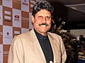
The captain of the 1983 World Cup winning team, Kapil Dev, started his cricket career playing for Haryana. The Nahar Singh Stadium in Faridabad was built in 1981 for international cricket matches. The Tau Devi Lal Stadium in Gurgaon is a large sports complex for many different sports.
The Chief Minister of Haryana, Manohar Lal Khattar, announced the "Haryana Sports and Physical Fitness Policy" in 2015. The goal is to make Haryana a major sports hub in India.
-

Wrestler Bajrang Punia
-
Cricketer Kapil Dev
-
Boxer Vijender Singh
-

Badminton player Saina Nehwal
.jpg)


.jpg)
Haryana is home to Haryana Gold, a professional basketball team.
At the 2016 Summer Olympics, Sakshi Malik won a bronze medal in wrestling. She became the first Indian female wrestler to win an Olympic medal.
Famous badminton player Saina Nehwal is from Hisar in Haryana.
Neeraj Chopra, a well-known athlete who won India's first track and field gold medal at the 2020 Tokyo Olympics in Javelin Throw, was born and raised in Panipat, Haryana.
Wrestling is very popular in Haryana. Two medals won in wrestling at the 2020 Tokyo Olympics were by athletes from Haryana.
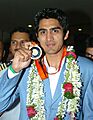
Ravi Kumar, an Indian freestyle wrestler from Nahri village in Sonipat District, won a silver medal at the 2020 Tokyo Olympics. He is also a bronze medalist from the 2019 World Wrestling Championships and has won the Asian championship twice.
|
See also
 In Spanish: Haryana para niños
- List of Monuments of National Importance in Haryana
- List of State Protected Monuments in Haryana
- Outline of Haryana
- Politics of Haryana
- Tourism in Haryana
- Haryanvi cinema
- List of earthquakes in Haryana
