
Grand Trunk Road facts for kids
Quick facts for kids Grand Trunk Road |
|
|---|---|
| Lua error in Module:Infobox_road/map at line 15: attempt to index field 'wikibase' (a nil value). | |
| Route information | |
| Length | 1,600 mi (2,500 km) |
| Existed | Antiquity–present |
| Major junctions | |
| East end | Chittagong, Bangladesh |
| West end | Kabul, Afghanistan |
The Grand Trunk Road (often called GT Road) is one of the oldest and longest main roads in South Asia. For hundreds of years, it has connected the eastern and western parts of the Indian subcontinent. It stretches from Bangladesh, through northern India, and into Pakistan and Afghanistan.
It was built by Sher Shah Suri and is also known as "Sadak E Sher Shah" (meaning "Road of Sher Shah") after him. This road has played a huge role in history, trade, and travel for many centuries.
Contents
A Road Through History
The Grand Trunk Road has a very long history, going back to ancient times. Parts of this route were used even before the Maurya Empire (around 322-185 BC). During that time, it was known as the "Uttarapatha," which means "Northern Road." It was important for trade and connecting different kingdoms.
Who Built the Modern Road?
The road as we know it today was greatly improved by Sher Shah Suri, an emperor who ruled parts of India in the 1500s. He rebuilt and extended the road to make travel easier and safer. He also added "kos minars" (mile pillars) and "sarais" (rest stops) along the way. These stops provided food, water, and shelter for travelers and their animals.
British Era Improvements
Later, during the time of British India, the road was further improved and maintained. It became a vital link for the British to move troops, goods, and communicate across their vast empire. The name "Grand Trunk Road" became popular during this period.
Where Does the Grand Trunk Road Go?
This amazing road is about 2,500 kilometers (1,600 miles) long. It starts in Chittagong, a city in Bangladesh, and travels westward.
Across India
In India, the GT Road passes through many important cities and regions. It goes through states like West Bengal, Uttar Pradesh, Delhi, and Punjab. In some parts of India, it matches up with modern national highways like NH 19 and NH 44.
Through Pakistan
After India, the road continues into Pakistan. It goes through major cities like Lahore, Gujranwala, and Peshawar. The road is a key part of Pakistan's transport system, connecting its eastern and western regions.
Ending in Afghanistan
Finally, the Grand Trunk Road reaches Afghanistan. Its westernmost stretch is the Kabul–Jalalabad Road, which connects the cities of Jalalabad and Kabul. This part of the road often goes through challenging mountain passes.

Why is the Grand Trunk Road Important?
The Grand Trunk Road is more than just a path; it's a living piece of history.
- Trade and Economy: For centuries, it has been a major route for trade, helping goods and ideas move between different regions. This helped local economies grow.
- Cultural Exchange: The road allowed people from different cultures to meet and share their traditions, languages, and beliefs.
- Military Movements: It was also important for armies and rulers to move their forces quickly across the subcontinent.
- Modern Use: Even today, parts of the Grand Trunk Road are busy highways, used by millions of people for travel and transport.
The Grand Trunk Road is a symbol of connection and history in South Asia.
Images for kids
-
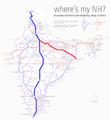
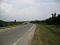
In India, GT Road coincides with NH 19 and NH 44 of National Highways in India.
-
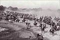
A scene from the Ambala cantonment in British India.
-
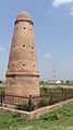
Mughal era Kos Minar along GT road at Sonipat, India
-
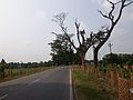
Grand Trunk Road in Uttarpradesh, India
-
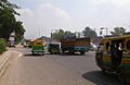
GT Road near Barhi, India
-
Grand Trunk Road towards Burdwan from Hooghly.
-
GT road in Gujranwala, Pakistan.
-
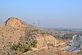
Original GT Road passing through Margalla Hills to Kala Chitta Range, Pakistan.
-
Newly realigned GT Road passing by the westernmost point of Margalla Hills to Kala Chitta Range, Pakistan.
-
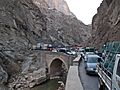
Kabul–Jalalabad Road, Afghanistan, is westernmost stretch of the GT Road.
-
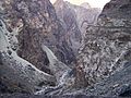
Mountain pass on the Kabul–Jalalabad Road, Afghanistan.
_hilight_19_44.png)


.jpg)

See also
 In Spanish: Grand Trunk Road para niños
