
Presidencies and provinces of British India facts for kids

The provinces of India were like big administrative areas or regions that the British government used to rule parts of the Indian subcontinent. Before they were called "provinces," they were known as "presidencies" or "presidency towns." Together, these areas were called British India. They existed for a long time, from 1612 until 1947, when India became independent.
We can look at their history in three main parts:
- 1612 to 1757: The East India Company, a British trading company, set up "factories" (which were like trading posts) in different places, mostly along the coast of India. They got permission from Indian rulers like the Mughal emperors or the Maratha empire. Other European countries like Portugal, Denmark, the Netherlands, and France also had trading companies. By the mid-1700s, three main "Presidency towns" became very important: Madras, Bombay, and Calcutta.
- 1757 to 1858: During this time, called Company rule in India, the East India Company slowly gained control over large parts of India. These areas were now called "Presidencies." The British government in England started to watch over the Company more closely, sharing power with it. The Company also lost some of its trading rights.
- 1858 to 1947: After the Indian Rebellion of 1857, the British government took over all power from the East India Company. This period was called the British Raj. The administrative areas grew to include other regions, like parts of Upper Burma. Over time, the large presidencies were broken down into smaller "Provinces" to make them easier to manage.
It's important to know that "British India" didn't include all of India. Many parts were still ruled by Indian princes in what were called princely states. These princes had some control over their own areas, but the British managed their defense, foreign relations, and communications. By 1947, there were over 500 such states! In the British Raj, the provinces made up about three-quarters of India's population and three-fifths of its land.
Contents
How British India Grew (1600–1947)
In 1608, the Mughal Empire allowed the English East India Company to set up a small trading spot in Surat (in today's Gujarat). This became the Company's first main office. Later, in 1611, they built a permanent trading post in Machilipatnam. By 1612, the Company joined other European traders in Bengal.
However, the Mughal Empire started to get weaker after 1707. First, the Maratha Empire became stronger, and then invaders from Persia (in 1739) and Afghanistan (in 1761) attacked. After the East India Company won important battles like the Battle of Plassey (1757) and the Battle of Buxar (1764) in Bengal, they began to take over more land in India. By the mid-1800s, after several wars with the Marathas, the East India Company became the most powerful force in South Asia. They held their land "in trust" for the British Crown (meaning, for the British King or Queen).
The Company's rule in Bengal ended in 1858, after the big Indian Rebellion of 1857. From then on, the areas directly ruled by the British were called British India. India officially became known as the Indian Empire in 1876. India was divided into two main parts: British India, which the British directly controlled, and the princely states, which were ruled by local Indian leaders. These local rulers could manage their own areas as long as they accepted British authority. In 1910, British India covered about 54% of the land and had over 77% of the population. There were also small areas controlled by Portugal and France.
India became independent from British rule in 1947. It was divided into two new countries: India and Pakistan. Pakistan included East Bengal, which is now the country of Bangladesh.
The term British India also included Burma (modern-day Myanmar) for some time. From 1824, parts of Burma, and by 1886, almost two-thirds of it, became part of British India. This lasted until 1937, when Burma became a separate British colony. Other nearby countries like Sri Lanka (then called Ceylon) and the Maldive Islands were also under British control but were not part of British India. At its largest, in the early 1900s, British India stretched from Persia in the west to China and Siam (Thailand) in the east. It even included Aden Province in the Arabian Peninsula.
British East India Company Rule (1793–1858)
The British East India Company started on December 31, 1600. It began trading with Indian rulers in Masulipatam in 1611 and Surat in 1612. In 1639, the Company rented a small trading post in Madras. Bombay was given to the British Crown by Portugal in 1661 as part of a wedding gift. The Crown then gave Bombay to the East India Company to manage.
In eastern India, the Company got permission from the Mughal Emperor Shah Jahan to trade in Bengal. They set up their first factory in Hoogly in 1640. Later, after the Mughal Emperor Aurengzeb forced them out, Job Charnock rented three small villages in 1686. These villages later became Calcutta, the Company's new main office.
By the mid-1700s, the three main trading settlements, with their factories and forts, were called the Madras Presidency, the Bombay Presidency, and the Bengal Presidency. Each was managed by a governor.
The First Presidencies
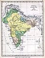
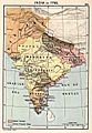
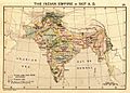
-
India in 1700, showing the Mughal Empire and European trading posts.
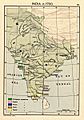
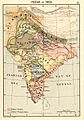
-
India in 1760, after the Battle of Plassey, showing the Maratha Empire and other states.
-
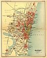
The city of Madras in a 1908 map. Madras was founded as Fort St. George in 1640.
-
The city of Bombay (shown in a 1908 map) was established in 1684.
-
The city of Calcutta (shown in a 1908 map) was established in 1690 as Fort William.


.jpg)
.jpg)

- Madras Presidency: Started in 1640.
- Bombay Presidency: The East India Company's main office moved from Surat to Bombay (now Mumbai) in 1687.
- Bengal Presidency: Started in 1690.
After Robert Clive won the Battle of Plassey in 1757, the East India Company put a new ruler, the Nawab of Bengal, in charge, but he was controlled by the Company. After another battle, the Battle of Buxar in 1764, the Company gained the right to collect land taxes in Bengal, which included present-day Bangladesh, West Bengal, Jharkhand, and Bihar. By 1773, the Company had full control over the expanded Bengal Presidency.
Parts of the Kingdom of Mysore were added to the Madras Presidency after the Third Anglo-Mysore War in 1792. In 1799, after Tipu Sultan was defeated in the Fourth Anglo-Mysore War, more of his land was added to Madras. In 1801, the Carnatic region, which was already under the Company's influence, became directly part of the Madras Presidency.
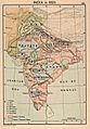
-
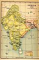
Map of India in 1765.
-
Map of India in 1795.
-
Map of India in 1805.
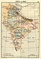
-
Map of India in 1823.
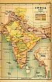
-
Map of India in 1837.
-
Map of India in 1848.
-
Map of India in 1857.
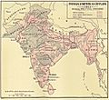
-
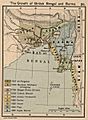
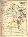
How British Bengal and Burma expanded.


New Provinces Emerge
By 1851, the East India Company's huge lands were still mostly grouped into four main territories:
- Bengal Presidency with its capital at Calcutta.
- Bombay Presidency with its capital at Bombay.
- Madras Presidency with its capital at Madras.
- North-Western Provinces with its main office in Agra. This area was first called the Ceded and Conquered Provinces and was renamed the North-Western Provinces in 1835.
By the time of the Indian Rebellion of 1857, and when the Company's rule ended, here's how the territories had changed:
- Bombay Presidency: Grew after the wars with the Marathas.
- Madras Presidency: Expanded in the late 1700s after the Carnatic Wars and Anglo-Mysore Wars.
- Bengal Presidency: Grew after the battles of Plassey (1757) and Buxar (1764), and after the Second and Third Anglo-Maratha Wars.
- Penang: Became part of the Bengal Presidency in 1786. It was later separated from British India in 1867.
- Ajmer-Merwara: Given to the British by the ruler of Gwalior in 1818.
- Coorg: Taken over by the British in 1834.
- Sind: Added to the Bombay Presidency in 1843.
- Punjab Province: Created in 1849 from lands taken during the wars with the Sikhs.
- Nagpur Province: Created in 1853 from the princely state of Nagpur. It was later merged into the Central Provinces in 1861.
- Oudh State: Taken over in 1856 and managed as a special area, part of the North-Western Provinces and Oudh.
-
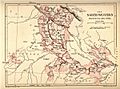
The North-Western Provinces, formed in 1836.
-
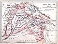
Punjab after it was taken over in 1849.
-
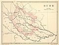
Oudh after it was taken over in 1856.


British Crown Rule (1858–1947)
When the British Crown took direct control in 1858, the old presidencies were still important. Until 1834, each presidency had its own governor and council who could make laws for their area. So, any new land added to a presidency would follow its existing laws.
However, some areas were acquired but not added to any of the three main presidencies. These were called 'non-regulation provinces'. They had different rules because they were not under the old presidency laws.
Major Provinces Under the Crown
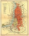
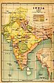
-
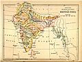
British India in 1880. This map shows the Provinces, Princely States, and Ceylon.
-
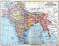
The Indian Empire in 1893 after Upper Burma and Baluchistan were added.
-
The Indian Empire in 1907 during the partition of Bengal.
-
The Indian Empire in 1915 after Bengal was reunited and new provinces were created.


Here are some of the major provinces that were created or changed during the British Raj:
- Central Provinces: Formed in 1861. Berar was added in 1903, and it was renamed Central Provinces and Berar in 1936.
- Burma: Lower Burma was added in 1852 and became a province in 1862. Upper Burma was added in 1886. Burma was separated from British India in 1937 and became its own British colony.
- Assam: Separated from Bengal in 1874. It was briefly part of a larger province called Eastern Bengal and Assam in 1905 but became a separate province again in 1912.
- Andaman and Nicobar Islands: Became a province in 1875.
- Baluchistan: Organized into a province in 1887.
-
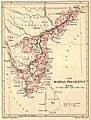
Madras Presidency in an 1880 map.
-
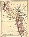
Bombay Presidency in an 1880 map.
-
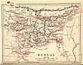
Bengal Presidency in 1880.
-
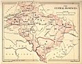
An 1880 map of Central Provinces.
-
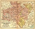
1908 map of Central Provinces and Berar.
-
Baluchistan in an 1880 map.
-
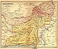
Baluchistan in 1908.


- North-West Frontier Province: Created in 1901 from parts of Punjab Province.
- Eastern Bengal and Assam: Created in 1905 when Bengal was divided. It was merged back with Bengal in 1912, and Assam became a separate province again.
- Bihar and Orissa: Separated from Bengal in 1912. It was renamed Bihar in 1936 when Orissa became a separate province.
- Delhi: Separated from Punjab in 1912 and became the capital of British India.
- Orissa: Became a separate province in 1936, formed from parts of Bihar-Orissa and Madras.
- Sind: Separated from Bombay in 1936.
- Panth-Piploda: Made a province in 1942.

By the early 1900s, British India had eight main provinces, each managed by a governor or lieutenant-governor. Here’s a quick look at their size and population (not including the princely states):
| Province of British India | Area (in thousands of square miles) | Population (in millions of inhabitants) | Chief administrative officer |
|---|---|---|---|
| Burma | 170 | 9 | Lieutenant-Governor |
| Bengal | 151 | 75 | Lieutenant-Governor |
| Madras | 142 | 38 | Governor-in-Council |
| Bombay | 123 | 19 | Governor-in-Council |
| United Provinces | 107 | 48 | Lieutenant-Governor |
| Central Provinces and Berar | 104 | 13 | Chief Commissioner |
| Punjab | 97 | 20 | Lieutenant-Governor |
| Assam | 49 | 6 | Chief Commissioner |
Smaller Provinces
There were also some smaller provinces managed by a chief commissioner:
| Minor Province | Area (in thousands of square miles) | Population (in thousands of inhabitants) | Chief administrative officer |
|---|---|---|---|
| North-West Frontier Province | 16 | 2,125 | Chief Commissioner |
| Baluchistan | 46 | 308 | British political agent in Baluchistan served as ex officio Chief Commissioner |
| Coorg | 1.6 | 181 | British Resident in Mysore served as ex officio Chief Commissioner |
| Ajmer-Merwara | 2.7 | 477 | British political agent in Rajputana served as ex officio Chief Commissioner |
| Andaman and Nicobar Islands | 3 | 25 | Chief Commissioner |
- Aden: This area, now part of Yemen, was a dependency of the Bombay Presidency from 1839 to 1932. It became a separate province in 1932 and then a British Crown Colony in 1937, no longer part of India.
India's Independence (1947)
When India gained independence in 1947, British India had 17 provinces:
- Ajmer-Merwara
- Andaman and Nicobar Islands
- Assam
- Baluchistan
- Bengal
- Bihar
- Bombay
- Central Provinces and Berar
- Coorg
- Delhi
- Madras
- North-West Frontier
- Orissa
- Panth-Piploda
- Punjab
- Sind
- United Provinces
When British India was divided into the Dominion of India and Dominion of Pakistan, eleven provinces joined India. These included Ajmer-Merwara-Kekri, Andaman and Nicobar Islands, Bihar, Bombay, Central Provinces and Berar, Coorg, Delhi, Madras, Panth-Piploda, Orissa, and the United Provinces.
Three provinces joined Pakistan: Baluchistan, North-West Frontier, and Sindh. The remaining three provinces—Punjab, Bengal, and Assam—were split between India and Pakistan.
In 1950, after India adopted its new constitution, the provinces in India were reorganized into new states and union territories. Pakistan kept its five provinces, one of which, East Bengal, was renamed East Pakistan in 1956 and later became the independent country of Bangladesh in 1971.
See also
 In Spanish: Presidencias y provincias de la India británica para niños
- British rule in Burma
- Danish India
- Dutch India
- French India
- Portuguese India
- Historiography of the British Empire
- Indian Princely States annexed by the British
- Maratha Empire
- Mughal Empire
- Salute state
- Sikh Empire
