Gujarat facts for kids
Quick facts for kids
Gujarat
ગુજરાત
|
|||
|---|---|---|---|
|
State of India
|
|||
|
|||
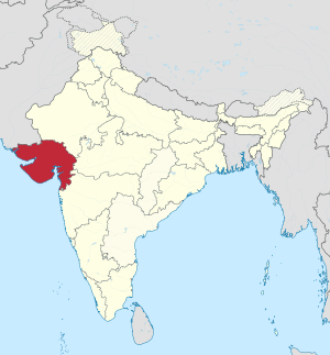
A map showing us where the location of Gujarat is in India
|
|||
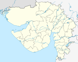
Map of Gujarat
|
|||
| Country | |||
| Region | West India | ||
| Established | 1 November 1956 | ||
| Area | |||
| • Total | 88,752 km2 (34,267 sq mi) | ||
| Population
(2011)
|
|||
| • Total | 91,347,736 | ||
| Time zone | UTC+05:30 (IST) | ||
| Official languages | Gujarati · English | ||
| 294 elected, 1 nominated | |||
Gujarat (Gujarati: ગુજરાત, Sindhi: گوجارات) is a large state in the western part of India. Its capital city is Gandhinagar, which was named after the famous Indian leader, Mahatma Gandhi.
Gujarat is located in the West Indian zone. It covers an area of about 75,686 square miles (196,077 square kilometers). This makes it bigger than countries like Syria but a bit smaller than Senegal. Part of its area includes the Kutch District.
The people of Gujarat mostly work in farming and business. The main languages spoken here are Gujarati and English.
Contents
Major Cities and Fun Places to Visit
Gujarat is home to many important cities and interesting places.
Important Cities
Some of the big and busy cities in Gujarat include:
- Surat
- Bharuch
- Ahmedabad
- Vapi
- Vadodara (also called Baroda)
- Porbandar
- Rajkot
- Jamnagar
Tourist Attractions
If you love to explore, Gujarat has many cool spots for tourists:
- Champaner
- Gondal
- Bhavnagar
- Utelia
- Zainabad
- Bhuj
- Sasangir
You can also visit the Statue of Unity, which is the world's tallest statue. It honors Sardar Vallabhbhai Patel, a very important leader in India's history.
Provincial Symbols of Gujarat
Every state has its own special symbols. Here are the symbols for Gujarat:
Economy and Industries
Gujarat is known for its strong economy. Many people work in farming, growing crops like cotton, groundnuts, and sugarcane. The state is also a big center for industries.
Manufacturing and Trade
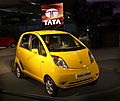
Gujarat has many factories that produce textiles, chemicals, and medicines. It also has important ports like Mundra Port and Kandla Port. These ports help India trade goods with other countries. The state is also home to the Tata Nano car factory in Sanand.
Energy and Innovation
Gujarat is a leader in renewable energy, especially solar power. It has large solar plants that help produce clean energy. The state also has a special financial hub called GIFT City, which is home to tall buildings and modern businesses.
Culture and Festivals
Gujarat has a rich and vibrant culture. People celebrate many festivals with great enthusiasm.
Festivals and Dances
- Navratri: This is one of the most famous festivals. People perform traditional dances like Garba and Dandiya Raas. These dances involve colorful costumes and lively music.
- International Kite Festival: Held in Ahmedabad, this festival attracts kite flyers from all over the world. The sky fills with colorful kites during this exciting event.
Food and Cuisine
Gujarati food is mostly vegetarian and known for its unique sweet and savory flavors. A traditional Gujarati meal, called a thali, includes many different dishes served together.
Wildlife and Nature
Gujarat is home to diverse wildlife, including some rare animals.
Animals of Gujarat
- Asiatic Lions: Gujarat is the only place in the world where you can find Asiatic lions in their natural habitat. They live in the Gir National Park.
- Flamingos: Large numbers of beautiful flamingos can be seen in the wetlands and coastal areas, especially near Jamnagar and the Rann of Kutch.
- Other Animals: You can also find animals like striped hyenas and various types of deer.
Natural Landscapes
- Rann of Kutch: This is a vast salt marsh that turns into a white desert during the dry season. It's famous for its unique landscape and the Rann Utsav festival.
- Saputara: This is a beautiful hill station, a cool place to visit in the mountains.
- Dinosaur Park: The Indroda Dinosaur and Fossil Park near Gandhinagar is a fun place to learn about dinosaurs and see their fossils.
Education
Gujarat has many good universities and colleges. Some well-known institutions include:
- Indian Institute of Management, Ahmedabad
- Gujarat National Law University, Gandhinagar
- Dhirubhai Ambani Institute of Information and Communication Technology, Gandhinagar
- Gujarat University, Ahmedabad
- Maharaja Sayajirao University of Baroda, Vadodara
These institutions help students learn about different subjects like business, law, technology, and arts.
Images for kids
-
A modern Zoroastrian Agiary in Western India
-
Portrait of Mughal Emperor Aurangzeb
-
Peshwa Baji Rao I riding a horse
-
Mahatma Gandhi picking salt at Dandi beach, South Gujarat ending the Salt satyagraha on 5 April 1930
-
Gandhinagar, the capital of Gujarat State. The picture shown above is of the Legislative Assembly and seat of Gujarat government. -
Surat is one of the fastest growing cities in the world.
-
An Asiatic lion family, which occurs in and around Gir National Park
-
Striped hyena at the Gir Forest National Park
-
Indroda Dinosaur and Fossil Park, Gandhinagar
-
Statue of Unity facing the Sardar Sarovar Dam on the river Narmada in Kevadiya colony
-
Kandla Port, Kutch
-
Indian Institute of Management, Ahmedabad
-
The Gujarat National Law University, Gandhinagar
-
Campus at Dhirubhai Ambani Institute of Information and Communication Technology, Gandhinagar
-
Mount Karo, Kutch
-
Cracked earth in the Rann of Kutch
-
The colourful Rann Utsav Festival is held annually in the Rann of Kutch.
-
People enjoying Raan Utsav at Dhordo, Kutch
-
Camel ride in Rann of Kutch
-
Hathisingh Jain Temple, Ahmedabad
-
Garba during Navaratri in Ahmedabad
-
Statue of Mahatma Gandhi in Sabarmati Ashram, Ahmedabad
-
Somnath Temple, Veraval
-
Dwarkadhish Temple, Dwarka
-
Akshardham Gandhinagar
-
Lakhota Museum in Jamnagar
-
Laxmi Vilas Palace, Vadodara
-
Vijay Vilas Palace, Mandvi, Kutch
-
Vasai Jain Temple, Kutch
-
Mandvi Beach, Kutch
See also
 In Spanish: Guyarat para niños
 | Bayard Rustin |
 | Jeannette Carter |
 | Jeremiah A. Brown |


