
Stockton Beach facts for kids
Quick facts for kids Stockton BeachNew South Wales |
|
|---|---|

Southern end of Stockton Beach seen from Shipwreck walk
|
|

North-eastern end of the beach at Anna Bay
|
|

Stockton Beach
Location in New South Wales
|
|
| Location | 32 km (20 mi) from Stockton to Anna Bay |
| LGA(s) | |
| Region | Hunter |
Stockton Beach is a long, sandy beach in New South Wales, Australia. It stretches for about 32 kilometres (20 miles) from Stockton to Anna Bay. This beach is famous for its huge sand dunes and its history.
Over the years, many ships have wrecked here, and even some planes have crashed. During World War II, the beach was used by the military. Today, it's a popular spot for people who love driving four-wheel drive (4WD) vehicles, fishing, and camping. You need a special permit to drive on the beach.
About Stockton Beach
Stockton Beach is part of the Tasman Sea coastline. It starts near Newcastle harbour and goes north-east towards Anna Bay. The beach can be very wide, up to 1 kilometre (0.6 miles) in some places. It has sand dunes that are over 30 metres (98 feet) high! These dunes are the largest moving sand dunes in the Southern Hemisphere. They actually move north by about 4 metres (13 feet) each year.
The sand on the beach changes daily. It can be hard-packed or very soft, depending on the wind and weather.
Worimi Conservation Lands
A big part of Stockton Beach is inside the Worimi conservation lands. These lands protect important natural and cultural areas. They include the Worimi National Park, Worimi State Conservation Area, and Worimi Regional Park. The NSW National Parks and Wildlife Service helps manage these lands.
History of the Beach
Aboriginal History and Culture
The Worimi Aboriginal people were the first inhabitants of this area. You can still see their ancient shell middens along the beach. Middens are piles of shells and other remains from their meals, some are up to 12,000 years old! These middens are very important to the Worimi people. Because the sand moves, some middens get covered, and new ones appear. There's a special area where driving is not allowed to protect these cultural sites.
Tin City: A Unique Settlement

In the late 1800s, two tin sheds were built on the beach to help sailors from shipwrecks. Later, during the 1930s Great Depression, people built more tin shacks there. This group of shacks became known as "Tin City."
During World War II, the army used the area, and some shacks were removed. Today, only eleven of these unique tin shacks remain. No new shacks can be built, and old ones cannot be rebuilt if they are destroyed by storms.
Wartime Defences and Aircraft Crashes

During World War II, Stockton Beach was prepared for a possible attack by Japanese forces. You can still see some of the old defences, like concrete pyramid-shaped blocks called "tank traps." These were meant to stop enemy tanks. Some of these traps have been moved, but many are still on the beach, and some are even hidden underwater.
The beach was also used as a bombing range by the Air Force. Pilots would drop unused bombs here before landing their planes. Sometimes, you can still see these old bombs in the sand!
Stockton Beach is very close to RAAF Base Williamtown, an Air Force base. Planes often fly over the beach. In 1960, a RAAF jet crashed on the beach, sadly killing the pilot. Parts of this plane still appear from time to time.
Shipwrecks on the Coast

Stockton Beach has seen many shipwrecks over the last 200 years. You can sometimes see parts of old wrecks wash ashore. Two of the most famous and visible wrecks are the Uralla and the MV Sygna.
The Uralla was a steamer that ran aground in a storm in 1928. No one was hurt, but the ship broke apart. You can sometimes see its remains at low tide.
The MV Sygna was a huge Norwegian cargo ship that got stuck during a big storm in 1974. People tried to pull it free, but they couldn't. The ship broke in half. The back part of the ship is still off Stockton Beach, slowly rusting away. You can usually see it easily from the southern end of the beach.
Fun on Stockton Beach
Popular Activities
Stockton Beach is a very popular place for camping. Sometimes, there can be thousands of campers and cars on the beach, especially on busy days. It's a great spot for outdoor adventures.
Driving on the Sand
You can drive on Stockton Beach with a 4WD vehicle, but you need to buy a permit first. Vehicles can enter the beach from Lavis Lane in Williamtown or Gan Gan Road in Anna Bay. It's important to drive carefully and stay off the plants and grasses on the sand dunes to protect the natural environment.
Wildlife You Might See
The waters near Stockton Beach are a nursery for young great white sharks. These sharks can be quite large, from 1.5 to 3 metres (5 to 10 feet) long. If you visit during migration season, you might also spot Humpback whales swimming past the coast.
The Big Beach Challenge
Since 2010, an event called the "Big Beach Challenge" takes place every year. People walk or run the entire length of Stockton Beach, from Birubi to the Stockton Surf Club. Some fast runners finish in under three hours, while walkers take about seven hours. There's also a shorter 16-kilometre (10-mile) event. This challenge helps raise money for a local charity called Harry's House.
Images for kids
-
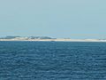
Wreck of the MV Sygna as seen from southern end of the beach, approximately 8.8 km (5.5 mi) to the south-west
-
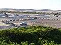
World War II tank traps surrounding lower car park at the northern end of the beach in Anna Bay
-
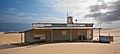
A Tin City shack
-
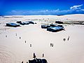
Aerial view of Tin City
-
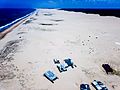
Aerial view of Stockton Beach and Tin City


