
Hunter Region facts for kids
Quick facts for kids Hunter RegionNew South Wales |
|||||||||||||||
|---|---|---|---|---|---|---|---|---|---|---|---|---|---|---|---|

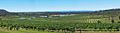
View across the Hunter Valley
|
|||||||||||||||

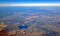
The mouth of the Hunter River at Newcastle
|
|||||||||||||||

Hunter Region
Location in New South Wales
|
|||||||||||||||
| Population | 682,465 (2021) | ||||||||||||||
| • Density | 30.07222/km2 (77.8867/sq mi) | ||||||||||||||
| Area | 22,694.2 km2 (8,762.3 sq mi) | ||||||||||||||
| Time zone | AEST (UTC+10) | ||||||||||||||
| • Summer (DST) | AEDT (UTC+11) | ||||||||||||||
| Location | 162 km (101 mi) N of Sydney | ||||||||||||||
| LGA(s) |
|
||||||||||||||
| State electorate(s) |
|
||||||||||||||
| Federal Division(s) | |||||||||||||||
|
|||||||||||||||
The Hunter Region, also known as the Hunter Valley, is a special area in northern New South Wales, Australia. It stretches about 162 to 310 kilometers (100 to 190 miles) north of Sydney. This region is home to the Hunter River and its smaller rivers, surrounded by hills to the north and south.
The Hunter Valley is one of the biggest river valleys on the NSW coast. It's famous for its many wineries and its important coal industry. Most people in the Hunter Region live close to the coast, within 25 kilometers (15 miles). More than half of the population lives in the cities of Newcastle and Lake Macquarie.
Many other towns and villages are spread across the region. These are part of eleven different local government areas. In 2021, the region had a population of 682,465 people. It's expected to grow to over 1,000,000 people by 2031. The Hunter Valley is also a well-known wine region in Australia. It played a big part in the history of Australian wine because it was one of the first places where grapes were planted in the early 1800s.
Contents
History of the Hunter Region
For more than 30,000 years, the Wonnarua people, who are Aboriginal Australians, lived in the area now called the Hunter Valley. They, along with the Worimi to the north and the Awabakal to the south, created a trade route. This route connected the Coquun (Hunter) Valley to the harbor now known as Sydney Harbour.

The history of winemaking in the Hunter Valley began with European settlement in the late 1700s. The British Empire set up a penal colony in New South Wales. The Hunter River was found by accident in 1797 by British Lieutenant John Shortland. He was looking for convicts who had escaped. Soon, the region became a valuable source of timber and coal. These resources helped power the steamships traveling from Sydney.
In 1820, a land explorer named John Howe created a path through the Australian wilderness. This path went from Sydney to the area now known as the Lower Hunter Valley. Today, the modern Putty Road follows Howe's exact path. It is a main road for tourists visiting the Hunter Valley from Sydney.
Early grape plantings near Sydney didn't do well because of the humidity. Plantings to the west were damaged by spring frosts. So, the Hunter region became the main wine area for the new colony. The Hunter Valley grew a lot in the mid to late 1800s. This was because it had a special position in the Sydney market. The government of New South Wales put high taxes on wines from other areas, like Victoria and South Australia. This made Hunter Valley wines cheaper and more popular.
After World War I, many Australian soldiers were given land in the Hunter Valley. This led to more grape planting for a while. However, the worldwide Great Depression and bad hail storms in 1929 and 1930 caused many growers to give up their vineyards.
Geography and Landscape
How the Land Was Formed

The Hunter Region is a meeting point between two different types of rock formations. To the south, there are older rocks from the Paleozoic era, part of the New England Fold Belt. To the north, there are younger rocks from the Early Permian and Middle Triassic periods, part of the Sydney Basin.
Between these two areas is a major geological crack called the Hunter-Mooki Thrust fault. This fault was once very active and created the Brokenback Range, which is a key feature in the Hunter region. You can also find strips of basalt rock throughout the area. This shows that there was volcanic activity here in the past.
The rocks in the central and southeastern parts of the Lower Hunter Valley formed when the area was a shallow ocean bay. This period left behind many layers of coal, which led to the early growth of the Hunter Valley in the 1800s. It also left a lot of salt in the underground water. As you go further north and west, towards the Brokenback Range and the Upper Hunter, you find more Triassic sandstone. Eventually, this leads to older carboniferous rocks that form the northern edge of the Hunter, near the Barrington Tops.
Overall, much of the Hunter Valley's soil isn't great for growing grapes. It often has hard, acidic clay that doesn't drain well. However, there are good areas too. In the Lower Hunter, soils range from sandy river flats (good for Semillon grapes) to deep, loose loam (good for Shiraz grapes). In the Upper Hunter, the rivers create black, silty loam soils. These are often on top of alkaline clay. On the hills of the Brokenback Range, there are strips of volcanic basalt. Growers like these soils because they help grapes grow stronger and have more flavor.
Rivers of the Region
The main river in the area is the Hunter River, which gives the region its name. Other rivers include the Allyn, Avon, Barrington, and many more.
Even though the region is named after it, the Hunter River isn't the most important natural feature. The Brokenback Range is more dominant. However, the larger Hunter river system, including the Goulburn River and other smaller rivers, provides important water for farming. This is especially true for the Upper Hunter, which can get very dry. The Hunter River starts in the Liverpool Range of the volcanic Barrington Tops. It flows south, then east, finally reaching the Pacific Ocean at the city of Newcastle.
Water Supply
Fresh water for the region comes from several sources. These are managed by Hunter Water and State Water Corporations. State Water Corporation's dams provide water for farming, coal mines, and power stations. They also supply drinking water to towns in the Upper Hunter Region. Hunter Water Corporation's dams supply water to the large population of over 500,000 people living near the coast, especially in Newcastle and Lake Macquarie.
Glenbawn Dam, the largest dam in the region, is on the Hunter River. Chichester Dam is on the Chichester River, and Lostock Dam is on the Paterson River. Grahamstown Dam is the largest dam for the urban areas of the lower Hunter. It gets its water from the Williams River, pumped through a station at Balickera. The dam itself doesn't collect much natural rainfall. In addition to dams, the lower Hunter also gets fresh water from the Tomago Sandbeds through a series of wells.
Towns and Cities
The Hunter Region has four main cities. From largest to smallest by population, they are Lake Macquarie, Newcastle, Maitland, and Cessnock. Other important towns in the Hunter Region include Dungog, Gloucester, Kurri Kurri, Muswellbrook, Raymond Terrace, Scone, and Singleton.
Climate

The Hunter Valley has a humid subtropical climate. This is similar to the Greater Western Sydney region, but it's also affected by the nearby Pacific Ocean. Because it's further north and close to the ocean, the Hunter Valley is one of Australia's hottest and wettest wine regions. Mountains to the west and north act like a funnel, pulling cool ocean breezes into the area. These breezes also bring heavy rainfall and sometimes strong storms in the summer and autumn.
In summer, the average daily temperature is usually above 21.1°C (70°F). In winter, the average temperature is around 14°C (57°F). In January, temperatures average between 22.7°C and 23.3°C (72.9°F and 73.9°F). It gets hotter the further you go inland, away from the cooling ocean. In spring, the Hunter Valley gets about 7.3 to 7.5 hours of sunshine each day.
During winter, westerly winds bring high-pressure weather systems that switch with cold fronts. This usually means drier weather in July and August. In summer, southeasterly winds bring a lot of moisture. More than two-thirds of the region's yearly rainfall happens between October and April. January and February are the wettest months.
| Climate data for Newcastle (coast) | |||||||||||||
|---|---|---|---|---|---|---|---|---|---|---|---|---|---|
| Month | Jan | Feb | Mar | Apr | May | Jun | Jul | Aug | Sep | Oct | Nov | Dec | Year |
| Record high °C (°F) | 42.5 (108.5) |
40.9 (105.6) |
39.0 (102.2) |
36.8 (98.2) |
28.5 (83.3) |
26.1 (79.0) |
26.3 (79.3) |
29.9 (85.8) |
34.4 (93.9) |
36.7 (98.1) |
41.0 (105.8) |
42.0 (107.6) |
42.5 (108.5) |
| Mean daily maximum °C (°F) | 25.6 (78.1) |
25.4 (77.7) |
24.7 (76.5) |
22.8 (73.0) |
20.0 (68.0) |
17.5 (63.5) |
16.7 (62.1) |
18.1 (64.6) |
20.2 (68.4) |
22.2 (72.0) |
23.6 (74.5) |
24.9 (76.8) |
21.8 (71.2) |
| Mean daily minimum °C (°F) | 19.2 (66.6) |
19.4 (66.9) |
18.3 (64.9) |
15.3 (59.5) |
12.0 (53.6) |
9.7 (49.5) |
8.5 (47.3) |
9.3 (48.7) |
11.5 (52.7) |
14.1 (57.4) |
16.2 (61.2) |
18.0 (64.4) |
14.3 (57.7) |
| Record low °C (°F) | 12.0 (53.6) |
10.3 (50.5) |
11.1 (52.0) |
7.4 (45.3) |
4.7 (40.5) |
3.0 (37.4) |
1.8 (35.2) |
3.3 (37.9) |
5.0 (41.0) |
6.5 (43.7) |
7.2 (45.0) |
11.0 (51.8) |
1.8 (35.2) |
| Average precipitation mm (inches) | 90.0 (3.54) |
107.4 (4.23) |
119.6 (4.71) |
116.9 (4.60) |
115.6 (4.55) |
117.5 (4.63) |
93.2 (3.67) |
73.2 (2.88) |
72.1 (2.84) |
72.5 (2.85) |
71.0 (2.80) |
80.9 (3.19) |
1,129.9 (44.48) |
| Average precipitation days | 11.1 | 11.2 | 12.4 | 12.3 | 12.6 | 12.3 | 11.2 | 10.5 | 10.0 | 10.9 | 10.8 | 10.6 | 135.9 |
| Average afternoon relative humidity (%) | 72 | 74 | 72 | 66 | 64 | 63 | 59 | 56 | 59 | 64 | 68 | 71 | 66 |
| Source: Bureau of Meteorology | |||||||||||||
| Climate data for Scone Airport (Upper Hunter Valley region) | |||||||||||||
|---|---|---|---|---|---|---|---|---|---|---|---|---|---|
| Month | Jan | Feb | Mar | Apr | May | Jun | Jul | Aug | Sep | Oct | Nov | Dec | Year |
| Record high °C (°F) | 43.5 (110.3) |
43.5 (110.3) |
41.0 (105.8) |
36.0 (96.8) |
28.7 (83.7) |
24.4 (75.9) |
24.5 (76.1) |
29.8 (85.6) |
34.1 (93.4) |
39.0 (102.2) |
43.4 (110.1) |
42.4 (108.3) |
43.5 (110.3) |
| Mean daily maximum °C (°F) | 31.1 (88.0) |
29.8 (85.6) |
27.9 (82.2) |
24.5 (76.1) |
20.1 (68.2) |
17.0 (62.6) |
16.3 (61.3) |
18.3 (64.9) |
21.5 (70.7) |
24.9 (76.8) |
27.7 (81.9) |
30.2 (86.4) |
24.1 (75.4) |
| Mean daily minimum °C (°F) | 16.9 (62.4) |
16.9 (62.4) |
14.6 (58.3) |
11.3 (52.3) |
8.1 (46.6) |
6.0 (42.8) |
4.7 (40.5) |
5.5 (41.9) |
7.9 (46.2) |
10.8 (51.4) |
13.3 (55.9) |
15.7 (60.3) |
11.0 (51.8) |
| Record low °C (°F) | 8.2 (46.8) |
8.6 (47.5) |
4.7 (40.5) |
1.3 (34.3) |
−1.0 (30.2) |
−2.0 (28.4) |
−2.7 (27.1) |
−3.0 (26.6) |
−1.3 (29.7) |
0.5 (32.9) |
5.0 (41.0) |
6.4 (43.5) |
−3.0 (26.6) |
| Average precipitation mm (inches) | 82.3 (3.24) |
77.3 (3.04) |
52.2 (2.06) |
38.9 (1.53) |
46.5 (1.83) |
45.5 (1.79) |
36.5 (1.44) |
38.1 (1.50) |
38.5 (1.52) |
57.8 (2.28) |
62.0 (2.44) |
67.9 (2.67) |
643.1 (25.32) |
| Average precipitation days | 8.3 | 7.8 | 7.1 | 6.7 | 7.4 | 9.4 | 8.1 | 7.6 | 7.0 | 8.8 | 8.6 | 8.6 | 95.4 |
Key Industries and Economy
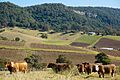
The Hunter Region has many important industries. These include coal mining, making things (manufacturing), farming, viticulture (grape growing) and winemaking, tourism, horse breeding, and producing electricity. There's also dairy and beef cattle farming, and all the services that support these industries. The Hunter Region is one of Australia's most famous places for growing grapes and making wine. It's known for both red and white wines.
Coal Mining in the Hunter


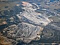
Coal mining is the most important economic activity in the valley. Companies like Rio Tinto and BHP mine coal, mostly for export to other countries. The Port of Newcastle is the world's largest place for exporting coal. Most of this coal arrives at the port by train. You can often see coal ships waiting off the coast of Newcastle.
Producing Electricity
Making electricity is a big industry in the region. This happens at several coal-fired power stations. These include Eraring, Bayswater, Liddell, Munmorah, Redbank, and Vales Point.
Horse Breeding
The Hunter Valley is Australia's main area for breeding and raising Thoroughbred horses. Many of the country's best racehorses come from here. The Upper Hunter area around Scone is one of the biggest horse breeding places in the world.
Tourism in Wine Country
Often called "Wine Country," the Hunter Valley is a major place for tourists in New South Wales. It's the 6th most visited spot in Australia, attracting over 2.5 million people every year. There are many events for visitors in the Hunter. For example, the Hunter Valley Steam Trains run on the first three Sundays of each month. You can also take scenic boat trips on the Hunter River and Lake Macquarie.
Wine Production
.jpg)
The Hunter Valley Wine Zone was officially recognized on May 1, 1996. It covers almost the entire area where the Hunter River and its smaller rivers flow. Inside this zone, there is one main wine region called Hunter. The Hunter Wine Region was officially declared on March 18, 1997. It's not as big as the whole Hunter Valley zone, but it includes most of the important vineyards. It does not go east of the Pacific Highway.
Some of the oldest grapevines in the Hunter Valley were planted in 1924 near the village of Fordwich. Pokolbin, located in the "Lower Hunter Valley," is the heart of the Hunter Valley wine country. This area claims to be Australia's oldest wine region. It is found between the towns of Cessnock and Branxton, about 50 kilometers (30 miles) west of Newcastle. Most of the wine country is in the Cessnock and Singleton local government areas. Being close to Sydney has helped the area invest in wine production and become a popular tourist spot.
Much of the rolling countryside around Pokolbin is covered with grapevines. It has many vineyards, restaurants, shops, golf courses, and country guesthouses. Other parts of the valley, like the Wollombi Valley and Broke Fordwich areas, are also well known for wine. The main town in the Upper Hunter Valley is Muswellbrook.
Local Government and Environment
Population and Local Areas
The Hunter Region includes several local government areas. These are like local councils that manage different parts of the region.
| Hunter rank | Local government area | Estimate resident population 30 June 2020 | 1 year growth rate | Population density (people/km2) |
|---|---|---|---|---|
| 1 | City of Lake Macquarie | 207,775 | 0.9 | 320.3 |
| 2 | City of Newcastle | 167,363 | 1.1 | 896.2 |
| 3 | City of Maitland | 87,395 | 2.6 | 223.2 |
| 4 | Port Stephens Council | 74,506 | 1.4 | 86.8 |
| 5 | City of Cessnock | 61,256 | 2.1 | 31.2 |
| 6 | Singleton Council | 23,380 | -0.3 | 4.8 |
| 7 | Muswellbrook Shire | 16,355 | -0.1 | 4.8 |
| 8 | Upper Hunter Shire | 14,167 | -0.1 | 1.7 |
| 9 | Dungog Shire | 9,664 | 2.6 | 4.3 |
| Hunter | 661,861 | 1.3 | 29.2 | |
Protecting the Environment
The Hunter Region is home to many national parks and nature reserves. These include the Goulburn River National Park, Myall Lakes National Park, Barrington Tops National Park, and Werakata National Park. These areas help protect the natural environment.
Within the Hunter, many endangered natural communities have been identified. These are special groups of plants and animals that are at risk. They are found on both public and private land. Before any land is developed, an environmental check must be done. This is to make sure it won't harm endangered species or communities. Some examples of these special communities in the Hunter Region are:
- Grey Box–Grey Gum Wet Sclerophyll Forest
- Hunter Floodplain Red Gum Woodland
- Hunter Lowland Redgum Forest
- Hunter Valley Vine Thicket
- Hunter Valley Weeping Myall Woodland
- Lower Hunter Valley Dry Rainforest
- Warkworth Sands Woodland. This special forest grows on sandy soils southeast of Singleton.
Movement for a New State
There is a group of people who want the Hunter Region to become its own state, separate from New South Wales. They are campaigning for this change. One reason they give is the sale of the Port of Newcastle. Another is that the NSW state government has not built a container terminal in Newcastle.
The group wants a special investigation (called a Royal commission) into whether the Hunter Valley could become a state. They also want a public vote on this idea by 2030. The Constitution of Australia allows new states to be formed. However, this can only happen if the parliament of the existing state agrees.
Images for kids
-
View across the Hunter Valley
-

The mouth of the Hunter River at Newcastle
-
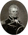
Lieutenant John Shortland was the first European to explore the Hunter River in 1797.
-
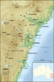
The Sydney Basin, showing the Hunter Valley and Barrington Tops to the north.
-
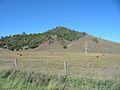
Parts of the Upper Hunter Valley can be very dry and experience drought conditions during the growing season.
-
Ravensworth open-cut coal mining operations by Glencore.
-
Aerial view of Hunter Valley coal operations, showing mines and power plants.
-
A Hunter Valley vineyard.
See also
 In Spanish: Valle de Hunter para niños
