
Hunter River (New South Wales) facts for kids
Quick facts for kids Hunter River |
|
|---|---|

Ship entering the mouth of the Hunter River at Newcastle
|
|
| Native name | Coquun |
| Other name(s) | Coquon P.T.O., First Hunter Creek, Coal River |
| Country | Australia |
| State | New South Wales |
| Region | NSW North Coast (IBRA), Sydney Basin (IBRA), Hunter |
| Local government areas | Upper Hunter, Muswellbrook, Singleton, Maitland, Dungog, Port Stephens, Newcastle |
| Major settlements and towns | Aberdeen, Muswellbrook, Denman, Jerrys Plains, Singleton, Maitland, Morpeth, Raymond Terrace, Newcastle |
| Physical characteristics | |
| Main source | Mount Royal Range, Liverpool Range within Barrington Tops National Park, Upper Hunter 1,420 m (4,660 ft) 31°53′36.5″S 151°27′04.4″E / 31.893472°S 151.451222°E |
| River mouth | Tasman Sea between Nobbys Head and Stockton 0 m (0 ft) 32°55′S 151°47′E / 32.92°S 151.79°E |
| Length | 300 km (190 mi) |
| Basin features | |
| Basin size | 21,367 km2 (8,250 sq mi) |
| Tributaries |
|
| Bridges | Ellerston, Aberdeen, Muswellbrook, Denman, Golden Highway, Singleton (x3), Elderslie, Melville Ford, Bolwarra Heights (rail), Maitland, Lorn, Morpeth, Millers Forest/Nelsons Plains, Hexham, Ash Island, Kooragang (rail), Tourle Street, Stockton |
| National park | Barrington Tops |
The Hunter River is a big river in New South Wales, Australia. The local Wonnarua Aboriginal people call it Coquun. This river starts in the Liverpool Range mountains. It flows south and then east, finally reaching the Tasman Sea at Newcastle. Newcastle is the second largest city in New South Wales and a very important port. The part of the river near the sea is a special type of estuary, where river water mixes with ocean water.
Contents
Journey of the Hunter River
The Hunter River begins its journey on the western slopes of the Mount Royal Range. This area is part of the Liverpool Range and is found inside Barrington Tops National Park. It starts near a town called Murrurundi. The river flows in different directions before it reaches Lake Glenbawn, a large dam. After the dam, it continues its path towards the Tasman Sea.
The river's mouth is in Newcastle, located between Nobbys Head and Stockton. Many smaller rivers and streams, called tributaries, join the Hunter River. Some of the main ones are the Pages, Goulburn, Williams, and Paterson rivers.
Near Hexham, the river splits into two main parts. These parts go around the Kooragang Wetlands, which is a special protected area. The two parts of the river then come back together near Newcastle's city center before flowing into the sea. The Hunter River drops about 1,397 meters (4,583 feet) from its start to the ocean.
Flooding and Towns Along the River
The Hunter River can have big floods. To help control these floods, the Lake Glenbawn was built near Scone. Even with the dam, major floods have happened. For example, a very bad flood in 1955 caused a lot of damage, especially in Maitland. There were also serious floods in 2007 and 2015.
Many towns are located along the Hunter River. Starting from the upper parts of the river and moving downstream, these towns include Aberdeen, Muswellbrook, Denman, Jerrys Plains, Singleton, Maitland, Morpeth, and Raymond Terrace.
Several major roads cross the Hunter River. The Pacific Highway crosses it at Hexham. The New England Highway crosses the river at Singleton and Aberdeen. The Golden Highway also crosses the river near Denman.
The Hunter Valley Region
The area around the Hunter River is known as the Hunter Valley. It's a great natural path to the inland parts of New South Wales. This valley is the largest low-lying area near the coast in the state. It is also drier than other coastal regions because mountains to its north block some of the rain.
The amount of rain changes across the valley. Newcastle, near the coast, gets about 1,100 millimeters (43 inches) of rain each year. In the upper parts of the valley, like at Merriwa and Scone, it's much drier, with only about 640 millimeters (25 inches) annually.
Climate and Land Use
Around the Barrington Tops area, which is on the northern side of the valley, it can rain a lot more. Sometimes, it gets as much as 2,000 millimeters (79 inches) of precipitation each year. In July, temperatures can even drop below 0°C (32°F), so some of this precipitation falls as snow.
In the lower parts of the valley, summer temperatures are usually around 27°C (81°F). In winter, the temperatures are milder, usually around 16°C (61°F).
The Hunter Valley has very rich, dark soils, especially upstream from Singleton. These soils are good for growing plants and are rare in Australia. Because of these fertile soils, there are many thoroughbred horse studs in the area. In other parts, like around Merriwa, the soils are not as rich, and the land is mostly used for grazing animals.
The Hunter Valley is famous for its grape growing and wine production. It is also a very important area for coal mining in Australia. However, the river and the region face challenges from drought and climate change. The coal mining industry also uses a lot of water, which can affect the river.
History of the Hunter River
The Hunter River has a long history. For thousands of years, the Wonnarua Aboriginal people lived along its banks. They called the river Coquun, which means "fresh water." The Awabakal people lived closer to the coast, near the mouth of the river. Both groups spoke similar languages.
European explorers first came to the river in the 1790s. In June 1796, some fishermen found coal there while looking for shelter from bad weather. Because of this, the river was first called the Coal River. In 1797, it was officially named the Hunter River. This name was chosen to honor Captain John Hunter, who was the Governor of the British colony in New South Wales at that time.
Between 1826 and 1836, convicts built a very long road called the Great North Road. This road was about 264 kilometers (164 miles) long and connected Sydney to the Hunter Region.
Gallery
-
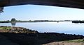
The Confluence where the Hunter River meets the Williams River at Raymond Terrace.
-
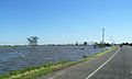
Flooding of the Hunter and Williams Rivers in Nelsons Plains during 2007.


_1.jpg)

