
Nobbys Head facts for kids
|
Native name:
Whibayganba
Nickname: Coal Island
|
|
|---|---|

Nobbys Head, Newcastle
|
|
| Geography | |
| Coordinates | 32°55′24″S 151°48′04″E / 32.92333°S 151.80111°E |
| Administration | |
| State | New South Wales |
| City | Newcastle |
| Additional information | |
| Time zone | |
| • Summer (DST) | |
Nobbys Head (also known by its Aboriginal name, Whibayganba) is a famous headland in New South Wales, Australia. It sits at the southern entrance of Newcastle Harbour. This headland overlooks the Hunter River and the Tasman Sea, which is part of the South Pacific Ocean.
Nobbys Head was first called Coal Island, then Nobbys Island. It was connected to the mainland by a long structure called the Macquarie Pier. This pier was finished in 1846. Later, a breakwater replaced the pier. Over time, sand built up along this breakwater, creating Nobby's Beach. Now, the sand and plants make the connection to the mainland look completely natural.
The original island's rock has many tunnels. These tunnels were dug in the 1850s by convicts. The goal was to destroy the island, but it still stands today.
A lighthouse called Nobbys Head Lighthouse is located on the headland. It was the third lighthouse built in New South Wales. The other two were the Macquarie Lighthouse (1818) and the Hornby Lighthouse (1858). The Nobbys Head lighthouse is so important that it's even on Newcastle's coat of arms!
Contents
Building the Macquarie Pier

.jpg)
The idea for a land bridge to connect Nobbys Island to the mainland came from Captain James Wallis. He suggested it to Governor Lachlan Macquarie. In August 1818, surveyor James Meehan drew up the plans for this pier.
Governor Lachlan Macquarie himself laid the first foundation stone on August 5, 1818. The pier was built using a type of strong cement called Roman cement. It took a long time to build, finally being completed in 1846. On June 12, 1846, Mr. Scott, the clerk of works, was the first person to walk the entire length of the breakwater to Nobbys Island.
By 1866, it was decided to rebuild the breakwater using stone. This stone was taken from a quarry in Waratah and brought to the site by train.
Finding the Original Foundation
The exact spot of the original foundation stone was lost for many years. In 2010, a new plaque was placed where people thought it might be. This was part of the Macquarie 2010 celebrations. The plaque was designed by Danylo Motyka.
Later, in August 2013, with money from the New South Wales government, scientists started looking for the buried structure. A geophysicist from GBG Australia used special tools like ground penetrating radar. They also used electrical resistance to find things underground. Their work found signs of a possible human-made structure about 1 meter (3 feet) below the surface.
Future Plans for the Pier
In 2020, the Newcastle City Council announced a project to improve the Macquarie Pier. This project aims to celebrate Newcastle's history with the sea. It will also connect the pier to the Bathers Way Coastal Walk.
The Port Authority plans to spend $3 million on this project. They will make the pathway wider, add sandstone seating, and put up new fencing. They will also add features that show the area's history along the 900-meter (about half a mile) route. This project was expected to be finished by the end of 2020.
Nobbys Head: History and Features
Captain James Cook was the first European to see Nobbys Head. He saw it on May 10, 1770, from his ship, the Endeavour. He described it as "A small round rock or Island, laying close under the land."
The island became important after coal was discovered by Lt. John Shortland in 1797. In 1804, Signal Head (part of Nobbys Head) was the first place in Newcastle to have a navigation aid. This was a light that burned coal. It was changed to oil for a short time in 1821 but went back to coal because the oil system wasn't reliable.
Changing the Island's Height
Nobbys Head was once much taller. It was thought to be about 62 meters (203 feet) high. However, studies in 2010 suggest it was more likely 43 meters (141 feet) high. Its height was reduced to its current 27.5 meters (90 feet). This was done because tall sailing ships would lose wind in their sails as they sailed around Nobbys Head. The rock removed from Nobbys was used to help build the pier.
In 2010, the NSW Government considered changing who managed the headland. They looked into transferring it from the Newcastle Port Corporation to the Land Property Management Authority. The idea was to possibly include it in a national park or nature reserve.
Images for kids
-
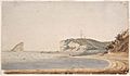
Nobby's Island and pier, Newcastle, 23 January 1820 / [watercolour by unknown artist]

