Paterson River facts for kids
Quick facts for kids Paterson River |
|
|---|---|

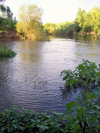
Paterson River at Vacy, joined by the Allyn River (top right)
|
|
| Other name(s) | Yimmang River, Cedar Arms River |
| Country | Australia |
| State | New South Wales |
| Region | NSW North Coast (IBRA), Hunter, Mid North Coast |
| Local government areas | Dungog; Maitland; Port Stephens |
| Towns | Gresford, Vacy, Paterson, Woodville, Hinton |
| Physical characteristics | |
| Main source | Barrington Tops near Careys Peak 256 m (840 ft) 32°3′43.26″S 151°24′57″E / 32.0620167°S 151.41583°E |
| River mouth | Hunter River Hinton 3 m (9.8 ft) 32°43′7.7″S 151°38′33.7″E / 32.718806°S 151.642694°E |
| Length | 159 km (99 mi) |
| Basin features | |
| River system | Hunter River catchment |
| Tributaries |
|
| National park | Barrington Tops National Park |
The Paterson River is a beautiful river in New South Wales, Australia. It's a perennial river, which means it flows all year round. This river is an important part of the larger Hunter River system. You can find it in the Hunter and Mid North Coast areas of the state.
Contents
Journey of the Paterson River
The Paterson River starts its journey high up in the Barrington Tops National Park. This is a special natural area located west of a place called Careys Peak. As the river flows, it generally moves towards the south and southeast.
Along its way, six smaller streams, called tributaries, join the Paterson River. One of the most important of these is the Allyn River, which meets the Paterson River near the town of Vacy. Finally, the Paterson River flows into the Hunter River between the towns of Hinton and Morpeth.
For a part of its path, between Hinton and Duns Creek, the Paterson River acts like a natural border. It separates the areas governed by the Port Stephens and Maitland local councils.
River Valleys and Farmland
The Paterson River flows through very rich and fertile farmland. This land is perfect for growing crops. It passes through the lovely Paterson and Allyn River Valleys. It also goes through the historic area known as Patersons Plains.
From its start to its end, the river drops about 933 metres (3,061 ft) in height. This happens over its total length of 151 kilometres (94 mi).
Lostock Dam
The river's flow is controlled by a large structure called Lostock Dam. This dam is located about 48 kilometres (30 mi) downstream from where the river begins. The dam was built by the New South Wales Department of Water Resources. Its main purpose is to provide water for irrigation. Irrigation means supplying water to farms so they can grow crops. The Lostock Dam was finished in 1971.
Tides and Towns
The Paterson River is tidal up to the village of Paterson and even past Vacy. This means that the water level in these parts of the river goes up and down with the ocean's tides.
There are several towns located along the Paterson River. These include Gresford, Vacy, Paterson, Woodville, and Hinton.
How the River Got Its Name
The area around the Paterson River was explored in 1801 by a person named Colonel William Paterson. Later, Governor King decided to name the river in his honour. That's how the Paterson River got its name!
 | John T. Biggers |
 | Thomas Blackshear |
 | Mark Bradford |
 | Beverly Buchanan |

