
Woodville, New South Wales facts for kids
Quick facts for kids WoodvilleNew South Wales |
|||||||||||||||
|---|---|---|---|---|---|---|---|---|---|---|---|---|---|---|---|

The historic timber general store at Woodville.
|
|||||||||||||||

Woodville
Location in New South Wales
|
|||||||||||||||
| Population | 604 (2011 census) | ||||||||||||||
| • Density | 25.6/km2 (66/sq mi) | ||||||||||||||
| Postcode(s) | 2321 | ||||||||||||||
| Elevation | 6 m (20 ft) | ||||||||||||||
| Area | 21.5 km2 (8.3 sq mi) | ||||||||||||||
| Time zone | AEST (UTC+10) | ||||||||||||||
| • Summer (DST) | AEDT (UTC+11) | ||||||||||||||
| Location |
|
||||||||||||||
| LGA(s) |
|
||||||||||||||
| Region | Hunter | ||||||||||||||
| County | Durham | ||||||||||||||
| Parish | Butterwick | ||||||||||||||
| State electorate(s) | Port Stephens | ||||||||||||||
| Federal Division(s) | Paterson | ||||||||||||||
|
|||||||||||||||
|
|||||||||||||||
Woodville is a country area, or suburb, located in the Hunter Region of New South Wales, Australia. It's special because it's split between two local government areas (LGAs): Port Stephens and Maitland. An LGA is like a local council that manages services for the area. Most of Woodville is east of the Paterson River, in the Port Stephens area. A smaller part, about 1.3 square kilometers, is west of the river and belongs to the Maitland area.
Contents
What is the Land Used For in Woodville?
Woodville is mostly used for farming. Farmers grow hay and raise beef cattle. You can also find turf farms, poultry farms, and olive groves here. However, more and more houses are being built, including smaller country lots. Woodville is on the floodplains of the lower Hunter River, so it can sometimes experience floods.
What Does the Woodville Township Look Like?
The center of Woodville is quite small. It has just a few buildings. There's an old timber shop, some houses of different ages, and the beautiful All Saints sandstone church. This church is built in a gothic style. It is now privately owned and no longer holds regular church services. However, the historic chapel is available for weddings, and the timber hall next to it is used for events.
Discovering Woodville's Past: A Brief History
Who Lived in Woodville First?
The Woodville area was originally home to Aboriginal people, most likely the Worimi tribe. This land was rich in natural resources. It had rivers, large wetlands, lakes, open woodlands, and even rainforests.
When Did Europeans Arrive in Woodville?
In the early 1800s, the first Europeans came to Woodville. They were timber-getters. They came to cut down the many red cedar trees growing near the Paterson and Hunter rivers. These trees were very valuable. Once cut, the logs were floated down the river to timber mills in Newcastle.
Important Historic Buildings in Woodville
Woodville has several important historical buildings. One is Dunmore House. The Woodville shop, which is a general store, is very special. It's Australia's oldest business that has been running continuously, offering the same services since 1844. Another important place is Stradbroke, a historic property with a homestead listed in the Australian Heritage Database.
The Woodville School of Arts was built in 1877. The All Saints Church, built in the Gothic Revival style, opened in 1864. It is a heritage-listed building. After restoration work in 1922, it got impressive arched and leadlight windows. The hall connected to the church was built in the 1890s and has interesting architecture. Iona School dates back to 1918. Today, weddings and receptions are often held at the church site.
How Woodville Got Its Name
There used to be another suburb called Woodville in Sydney. This caused confusion. To fix this, the Sydney suburb's name was changed to Villawood. This way, there was only one Woodville.
How to Get Around Woodville: Transport Options
Hunter Valley Buses operates one bus route that goes through Woodville:
- 185: This bus travels from Maitland to Gresford. It passes through Bolwarra, Largs, and Paterson.
The Historic Dunmore Bridge
The Dunmore Bridge crosses the Paterson River. It is a heritage-listed wooden bridge built in 1899. It's an Allan truss lift-span bridge. This means it had a part that could lift up to let boats pass, though it doesn't work anymore. The bridge is on Clarence Town Road. This is the main road connecting Maitland to places like Paterson, Seaham, Clarence Town, and Dungog.
Images for kids
-
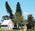
All Saints Church and hall
-
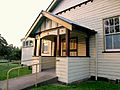
Iona School of Arts, a community hall
-
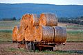
Hay wagon at Woodville
-
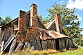
An old abandoned timber and brick house at Iona, Woodville


