Seaham, New South Wales facts for kids
Quick facts for kids SeahamNew South Wales |
|||||||||||||||
|---|---|---|---|---|---|---|---|---|---|---|---|---|---|---|---|

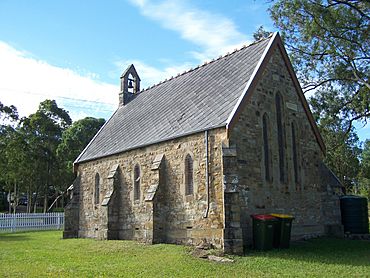
St. Andrews Anglican Church, dedicated 1860
|
|||||||||||||||
| Population | 1,025 (2011 census) | ||||||||||||||
| • Density | 23.9/km2 (62/sq mi) | ||||||||||||||
| Established | 1822 | ||||||||||||||
| Postcode(s) | 2324 | ||||||||||||||
| Area | 42.8 km2 (16.5 sq mi) | ||||||||||||||
| Time zone | AEST (UTC+10) | ||||||||||||||
| • Summer (DST) | AEDT (UTC+11) | ||||||||||||||
| Location |
|
||||||||||||||
| LGA(s) | Port Stephens Council | ||||||||||||||
| Region | Hunter | ||||||||||||||
| Parish | Seaham | ||||||||||||||
| State electorate(s) | Port Stephens | ||||||||||||||
| Federal Division(s) | Lyne | ||||||||||||||
|
|||||||||||||||
|
|||||||||||||||
Seaham is a small town in the Hunter Region of New South Wales, Australia. It's part of the Port Stephens Council area. Seaham sits right by the Williams River. This river flows into the larger Hunter River about 14.6 kilometers (9 miles) away, near Raymond Terrace.
Seaham is mostly a country area with a growing number of people living there. The main village of Seaham is quite small. It has only a few streets and is located in the northeast part of the wider Seaham area. The entire suburb of Seaham covers about 42.8 square kilometers (16.5 square miles). In 2011, about 1,025 people lived in Seaham. The larger "Greater Seaham" area includes nearby places like East Seaham, Brandy Hill, and Eagleton.
Contents
Seaham's Past: A Look at History
Early Aboriginal Life
Long before European settlers arrived, the land where Seaham is now was home to the Garewagal clan. They were part of the Worimi people, who are the traditional owners of this area.
How Seaham Began: The 1800s
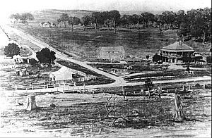
In 1822, a surveyor named Henry Dangar started mapping out the Hunter Valley. He divided the land into different sections. He set aside land for a town where Seaham village is today. Around this time, there was also a military station in Seaham.
The village of Seaham was officially announced on July 26, 1838. Over the years, Seaham became an important meeting point. It connected nearby towns like Raymond Terrace and Maitland.
In 1838, Dr. Henry Carmichael started a vineyard called "Porphyry Point" north of the village. This vineyard grew well and won many awards in Australia and Europe. The last wine was made at Porphyry in 1915. After that, the name and brand were sold to Lindemans winery.
Seaham faced big floods in the 1800s. In 1893, homes near the Williams River were flooded. This caused a lot of damage and many farm animals were lost. Another flood in 1913 also destroyed crops and drowned animals.
Seaham in the 1900s
Before the railway line was built between Maitland and Paterson in 1911, a line through Seaham was considered. This proposed railway would have connected Morpeth and Clarence Town, passing through Seaham. An 1887 map of Seaham shows this planned railway crossing the Williams River.
In 1903, the Seaham Hotel opened its doors at the corner of Dixon and Vine Streets. Thomas McDonald was the owner until 1920. Later, due to less traffic and fewer people, the hotel closed in 1932. In 1935, the two-story brick building was completely destroyed by fire.
Seaham Today: The 2000s
In 2002, Seaham held special celebrations called "Seaham Celebrates." These events marked important anniversaries. It was 150 years since Seaham Public School opened. It was also 100 years for both the Seaham School of Arts and St. Andrew's Anglican Church. These celebrations were similar to those held for Seaham's 100th birthday in 1938.
 | William L. Dawson |
 | W. E. B. Du Bois |
 | Harry Belafonte |


