
Brandy Hill, New South Wales facts for kids
Quick facts for kids Brandy HillNew South Wales |
|||||||||||||||
|---|---|---|---|---|---|---|---|---|---|---|---|---|---|---|---|

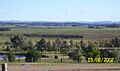
Looking from Brandy Hill across the site of Ahalton Farm, towards Mount Kanwary.
|
|||||||||||||||

Brandy Hill
Location in New South Wales
|
|||||||||||||||
| Population | 673 (2011 census) | ||||||||||||||
| • Density | 103.5/km2 (268/sq mi) | ||||||||||||||
| Established | 1986 | ||||||||||||||
| Postcode(s) | 2324 | ||||||||||||||
| Area | 6.5 km2 (2.5 sq mi) | ||||||||||||||
| Time zone | AEST (UTC+10) | ||||||||||||||
| • Summer (DST) | AEDT (UTC+11) | ||||||||||||||
| Location |
|
||||||||||||||
| LGA(s) | Port Stephens Council | ||||||||||||||
| Region | Hunter | ||||||||||||||
| County | Durham | ||||||||||||||
| Parish | Seaham | ||||||||||||||
| State electorate(s) | Port Stephens | ||||||||||||||
| Federal Division(s) | Paterson | ||||||||||||||
|
|||||||||||||||
|
|||||||||||||||
Brandy Hill is a suburb in the Hunter Region of New South Wales, Australia. It is part of the Port Stephens Council area. This area was once farmland. In the 1980s, it was divided into smaller blocks for homes.
Today, nearly 700 people live in Brandy Hill. Many homes are on large blocks of land. The suburb looks out over active farms. You can see great views of the wider Morpeth area, even as far as Maitland.
Contents
Geography of Brandy Hill
Brandy Hill is mostly a high area. The homes are about 20 to 40 meters (66 to 131 feet) above sea level. To the north and east, Brandy Hill borders Seaham. To the south and west, it is surrounded by the Hunter River floodplains. These floodplains are in Nelsons Plains, Wallalong, and Seaham.


History of Brandy Hill
First People of the Land
The land around Brandy Hill has a long history. The Worimi people were the traditional owners of this area. They had a clan called the Garewagal. Their land stretched from the Hawkesbury River to the Manning River. It went from the ocean in the east to the Hunter River in the west.
The Worimi people spoke a language called Kattang. They were food gatherers. This means they found their food from nature. They gathered plants and hunted animals. They did not farm the land. Each person had a special animal or plant called a totem. They would not harm their totem.
The Worimi people were skilled at making things. They made strong bags from native twine. They also made scoop nets for fishing. They carried water in hollowed wood or bark. Their fishing hooks were made from shells.
When the first European settlers arrived, the lives of the Worimi people changed greatly. Their traditional hunting grounds were used for other purposes. The Worimi people faced many challenges as their way of life was impacted. Sadly, the full-blooded Aboriginal population of the Williams River area no longer exists.
Early European Settlement
Modern Brandy Hill is built on what was once Ahalton Farm and Warren's Station Paddock. In 1823, James McClymont was given 2000 acres of land here. This land became known as "Ahalton Farm."
McClymont and his family did not stay long. In 1825, a group of bushrangers caused trouble at their farm. The family soon left the area. After McClymont passed away in 1829, Ahalton Farm was offered for rent. It was described as a good farm near the Hunter River. It had plenty of water and was close to other settlements.
In 1847, a Free Presbyterian Church was built at Ahalton. It was near where Ralston Road is today. The church was approved for sale in 1868.
There was once a plan to build a railway through Morpeth and Seaham. This railway would have gone through Brandy Hill. Some people thought it was not a good idea. They said the land was not suitable for many people.
North of Brandy Hill is the Brandy Hill quarry. It is named after a nearby hill that is about 180 meters (590 feet) high. A road called Brandy Hill Drive was built. It made it easier to travel between the quarry and Raymond Terrace. Today, some local residents are concerned about the quarry expanding. They worry about the impact on koala breeding habitats.
Brandy Hill Becomes a Suburb
In the 1980s, the land around Brandy Hill Drive was divided into smaller plots. It was then named "Brandy Hill." The name came from the hill and the quarry. Brandy Hill Drive is still used to reach the quarry, which is now run by Hanson plc.
On April 16, 1993, the official borders of Brandy Hill were set. Then, on April 7, 2000, the area was officially approved as a suburb. Brandy Hill is almost completely surrounded by the suburb of Seaham.
Images for kids
-
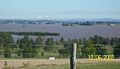
Views towards Hinton from Brandy Hill across the Hunter River floodplains.
-
The same area after the floodwaters had subsided.
