Paterson, New South Wales facts for kids
Quick facts for kids PatersonNew South Wales |
|||||||||||||||
|---|---|---|---|---|---|---|---|---|---|---|---|---|---|---|---|

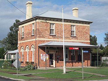
Paterson Post Office on the corner of Duke and King Streets
|
|||||||||||||||
| Population | 892 (2016 census) | ||||||||||||||
| • Density | 21.55/km2 (55.8/sq mi) | ||||||||||||||
| Established | 1833 | ||||||||||||||
| Postcode(s) | 2421 | ||||||||||||||
| Elevation | 30 m (98 ft) | ||||||||||||||
| Area | 41.4 km2 (16.0 sq mi) | ||||||||||||||
| Location | |||||||||||||||
| LGA(s) |
|
||||||||||||||
| County | Durham | ||||||||||||||
| Parish | Houghton | ||||||||||||||
| State electorate(s) | Upper Hunter | ||||||||||||||
| Federal Division(s) | Paterson | ||||||||||||||
|
|||||||||||||||
|
|||||||||||||||
Paterson is a small town in the Hunter Region of New South Wales, Australia. It is located on the Paterson River. The town is part of both Dungog Shire and the City of Maitland.
Paterson was once known for its dairy farms, timber, and citrus fruits. Today, it helps support the mining industry in the Upper Hunter area. It also connects to the larger city of Newcastle. The town was named after Colonel William Paterson. He explored the river area in 1801.
Contents
Where is Paterson Located?
Paterson is about a 15-minute drive north of Maitland. You can get there using Tocal Road or Paterson Road.
The Paterson railway station is on the North Coast railway line. This line connects Sydney and Brisbane. Trains run daily from Paterson north to Dungog and south-east to Newcastle.
Nearby areas include Duns Creek, Martins Creek, and Vacy.
Paterson's Weather and Climate
| Climate data for Paterson (Tocal AWS) (1991–2020 normals, extremes 1967–present) | |||||||||||||
|---|---|---|---|---|---|---|---|---|---|---|---|---|---|
| Month | Jan | Feb | Mar | Apr | May | Jun | Jul | Aug | Sep | Oct | Nov | Dec | Year |
| Record high °C (°F) | 46.0 (114.8) |
47.0 (116.6) |
41.2 (106.2) |
37.3 (99.1) |
29.5 (85.1) |
26.1 (79.0) |
27.3 (81.1) |
30.4 (86.7) |
36.2 (97.2) |
40.1 (104.2) |
43.9 (111.0) |
45.0 (113.0) |
47.0 (116.6) |
| Mean daily maximum °C (°F) | 30.6 (87.1) |
29.5 (85.1) |
27.4 (81.3) |
24.5 (76.1) |
21.0 (69.8) |
18.0 (64.4) |
17.8 (64.0) |
19.8 (67.6) |
23.0 (73.4) |
25.7 (78.3) |
27.3 (81.1) |
29.1 (84.4) |
24.5 (76.1) |
| Daily mean °C (°F) | 24.3 (75.7) |
23.6 (74.5) |
21.7 (71.1) |
18.5 (65.3) |
15.3 (59.5) |
12.9 (55.2) |
12.1 (53.8) |
13.3 (55.9) |
16.1 (61.0) |
18.7 (65.7) |
20.8 (69.4) |
22.8 (73.0) |
18.3 (64.9) |
| Mean daily minimum °C (°F) | 18.0 (64.4) |
17.7 (63.9) |
15.9 (60.6) |
12.5 (54.5) |
9.6 (49.3) |
7.8 (46.0) |
6.5 (43.7) |
6.7 (44.1) |
9.2 (48.6) |
11.6 (52.9) |
14.4 (57.9) |
16.4 (61.5) |
12.2 (54.0) |
| Record low °C (°F) | 8.6 (47.5) |
9.4 (48.9) |
7.7 (45.9) |
1.3 (34.3) |
0.5 (32.9) |
−0.3 (31.5) |
−4.7 (23.5) |
−1.5 (29.3) |
−0.6 (30.9) |
3.4 (38.1) |
5.3 (41.5) |
6.2 (43.2) |
−4.7 (23.5) |
| Average precipitation mm (inches) | 85.4 (3.36) |
116.6 (4.59) |
114.6 (4.51) |
84.6 (3.33) |
61.2 (2.41) |
85.3 (3.36) |
41.0 (1.61) |
35.0 (1.38) |
49.1 (1.93) |
59.7 (2.35) |
85.2 (3.35) |
90.9 (3.58) |
908.6 (35.77) |
| Average precipitation days (≥ 1 mm) | 7.8 | 8.7 | 8.9 | 7.3 | 6.4 | 7.8 | 6.1 | 4.7 | 5.8 | 6.4 | 8.7 | 8.3 | 86.9 |
| Average dew point °C (°F) | 17.4 (63.3) |
17.6 (63.7) |
16.4 (61.5) |
13.3 (55.9) |
10.1 (50.2) |
8.3 (46.9) |
6.6 (43.9) |
6.0 (42.8) |
8.0 (46.4) |
10.8 (51.4) |
13.4 (56.1) |
15.4 (59.7) |
11.9 (53.4) |
| Source 1: National Oceanic and Atmospheric Administration | |||||||||||||
| Source 2: Bureau of Meteorology | |||||||||||||
A Look at Paterson's History
The land around Paterson was originally home to the Wonnarua and Worimi peoples. These are Aboriginal Australian groups. The first European to officially explore the area was Colonel William Paterson in 1801. The river was named in his honor by Governor King.
Early European settlers were often timber cutters. They came looking for valuable red cedar trees. The Hunter River, which the Paterson River flows into, was even called the "Cedar Arm" because of all the trees.
Early Farming at Patersons Plains
In 1812, Governor Macquarie allowed four convicts and John Tucker jnr to start farming. This was at a place called "Patersons Plains" on the Paterson River. It later became known as "Old Banks." This was a reward for providing 500 cedar logs to the government.
Old Banks was one of the first rural settlements outside of Sydney. By 1818, there were eight farms along the river. Six of these farms belonged to former convicts. A military station and lock-up were also set up there. This helped keep order and served as a court.
Over time, Old Banks became less important. A new government settlement grew quickly at Wallis Plains (now East Maitland). This was about 10 kilometers south. In 1823, a direct road to Sydney was built. This made Wallis Plains and the port of Morpeth the main centers for the Lower Hunter Valley.
However, the military outpost at Old Banks still played a role. It helped catch escaped convicts. It also maintained law and order in the Paterson region. It was an important place for moving goods and people.
The first official land grant in the area was given to Captain William Dun in 1821. This land was a few kilometers north of Old Banks. In 1822, James Webber started "Tocal" on his land. Tocal became one of the most successful farms on the lower Paterson River.
The Modern Town of Paterson
The Paterson town we know today is about six kilometers north of Old Banks. It was the third town surveyed in the Hunter Valley. It was officially declared a town in 1833. As more people settled, Paterson became an important river port. It also served as a center for the surrounding community.
Many early settlers were Scots. Because of this, a Presbyterian Church was built before an Anglican one. St Ann's, which opened in 1842, is believed to be the oldest Presbyterian Church on mainland Australia.
River trade started to slow down in the 1850s as roads improved. Timber mills were set up by the 1870s. In its busiest times, Paterson had many businesses. These included four stores, five hotels, two shipyards, a sawmill, and a tannery. People also grew tobacco, grains, grapes, wine, citrus fruits, and cotton. These goods were sent by steamboat to Morpeth, Newcastle, and Sydney.
By the time the railway arrived in 1911, river transport was already declining. The railway line even passed right over the old wharf. In 1909, a boat called the Anna Maria sank during the railway bridge construction. It was carrying steel girders. The boat was saved but almost burned down later by a spark from a steam train. The last steamboats visited the area in the 1930s.
Throughout the 20th century, farming was the main source of income. Citrus fruit production was very strong around 1900. About 30,000 cases of citrus were handled at the port each year.
In the 2006 census, Paterson had a population of 345 people.
St Paul's Church
Before St Paul's Church was built, religious services were held in homes. George Augustus Middleton often led these services. In January 1836, local people raised money to build a church. On October 26, 1839, Rev. John Jennings Smith became the town's first resident minister. He built a small stone building on Church land. It was at the corner of King and Duke streets. This building was used as both a church and a school.
In 1892, the large corner block was sold to the Commercial Bank Co. The money from the sale was used to build a parish hall. The main church building was started and finished in 1845.
Important Heritage Sites
Paterson has several places that are protected for their historical importance:
- 18 King Street: Royal Oak Arms Hotel
- Tocal Road: Tocal Homestead
- 5 Webbers Creek Road: Rail Motor Society Collection
Paterson Today
There is an active historical society in Paterson. They work to preserve important historical sites. The society has a museum collection at the Paterson Court House. It is open once a week for visitors.
Paterson also has a local school, Paterson Public School. The town's newsletter is called The Paterson "Psst".
In March, Paterson holds an annual festival at Tucker Park. It features market stalls and local produce. The nearby Tocal Agricultural College hosts a small farms Field Day. This event happens on the first weekend of May. It shows off the college and local farming interests.
The Paterson Classic Car show takes place in mid-September. It displays vintage cars, trucks, and bikes. There are also market stalls and live music.
The Paterson Gallery showcases local artworks that are available for purchase. They have an open night on the first Friday of every month. Everyone is welcome to attend. The Rail Motor Society is located across from the Paterson railway station.
Famous People from Paterson
- Bushranger Captain Thunderbolt's wife, Mary Ann Bugg, was connected to the Paterson Court House in the 1860s.
 | Jewel Prestage |
 | Ella Baker |
 | Fannie Lou Hamer |


