
Brisbane facts for kids
Quick facts for kids BrisbaneQueensland |
|||||||||
|---|---|---|---|---|---|---|---|---|---|

Map of the Brisbane metropolitan area
|
|||||||||

Brisbane
Location in Australia
|
|||||||||
| Population | 2,706,966 (2023) (3rd) | ||||||||
| • Density | 159/km2 (410/sq mi) (2021 GCCSA) | ||||||||
| Established | May 1825 (exact date unknown) |
||||||||
| Elevation | 32 m (105 ft) | ||||||||
| Area | 15,842 km2 (6,116.6 sq mi) | ||||||||
| Time zone | AEST (UTC+10:00) | ||||||||
| Location | |||||||||
| LGA(s) |
|
||||||||
| Region | South East Queensland | ||||||||
| County | Stanley, Canning, Cavendish, Churchill, Ward | ||||||||
| State electorate(s) | 41 divisions | ||||||||
| Federal Division(s) | 17 divisions | ||||||||
|
|||||||||

.jpg)
.jpg)
.jpg)
.jpg)

_(2).jpg)
Brisbane is the capital and largest city of Queensland, a state in Australia. It is the third-most populated city in Australia and Oceania, with over 2.7 million people. Brisbane is located in the middle of South East Queensland, a large urban area with about 4 million residents.
The city's main area, called the Brisbane central business district, sits on a bend of the Brisbane River. This river was named after Sir Thomas Brisbane, a British army general and former Governor of New South Wales. Brisbane is built on a hilly floodplain in the Brisbane River Valley. It is between Moreton Island and the Taylor and D'Aguilar mountain ranges.
Brisbane started as a place for convicts in 1824 at Redcliffe. In 1825, it moved to North Quay on the Brisbane River. The first free settlers arrived in 1838. In 1859, Brisbane became Queensland's capital when the state separated from New South Wales.
Today, Brisbane is a major city known for research and new ideas. It is also a big transport hub with large networks for trains, buses, and ferries. It has Brisbane Airport, Australia's third-busiest airport, and the Port of Brisbane, Australia's third-busiest seaport.
Brisbane is a very diverse city, with over 36% of its people born in other countries. It often ranks high as one of the best cities to live in. Brisbane has hosted many big events, like the 1982 Commonwealth Games and World Expo 88. It will also host the 2032 Summer Olympics and 2032 Summer Paralympics.
Brisbane is a popular place for tourists and is known as Australia's greenest city. South Bank and its beautiful South Bank Parklands attract over 14 million visitors each year. Other famous spots include the Queensland Cultural Centre, Brisbane City Hall, the Story Bridge, and Mount Coot-tha Lookout. The city is also famous for its old "Queenslander" style houses and many parks.
Contents
- Brisbane's Name and History
- Brisbane's Geography and Nature
- Brisbane's City Layout
- People and Culture of Brisbane
- Brisbane's Economy and Shopping
- Culture and Sports in Brisbane
- Tourism and Fun in Brisbane
- How Brisbane is Governed
- Education in Brisbane
- Brisbane's Infrastructure
- Media in Brisbane
- Sister Cities
- See also
Brisbane's Name and History
What's in a Name?
Brisbane gets its name from the Brisbane River. The river was named after Sir Thomas Brisbane, who was the governor of New South Wales from 1821 to 1825.
People sometimes call Brisbane "Brissie," "Brisvegas," or "the River City."
The area where Brisbane is located was originally known as Meanjin by the local Aboriginal people. This name might mean "place shaped as a spike" or "the spearhead," referring to the shape of the Brisbane River. Some also say it means "the place of the blue water lilies."
Early History of Brisbane
Aboriginal Australians have lived in this area for at least 22,000 years. Before Europeans arrived in the 1820s, there were between 6,000 and 10,000 Indigenous people here. The main Aboriginal groups in the area were the Yagara, Turrbal, and Quandamooka peoples. The rivers were very important for food like fish and crabs.
In 1770, British explorer James Cook sailed past the bay and named it "Moreton Bay." Later, in 1823, Governor Thomas Brisbane asked for a new convict settlement to be built in the north. John Oxley explored the Brisbane River and named it after the governor.
The first convict settlement started at Redcliffe in 1824. But after a year, the settlers moved to North Quay on the Brisbane River because it had a better water supply. This new area was named Brisbane.

One of the oldest buildings in Queensland is The Old Windmill, built by convicts in 1828. It was used for grinding grain.
In 1838, German missionaries started the first free settlement at Nundah. More free settlers arrived, and by 1842, Brisbane was officially a free settlement. In 1859, Queensland became a separate colony from New South Wales, and Brisbane was chosen as its capital.
Growth and Challenges in the 1800s
In 1864, a big fire, known as the Great Fire of Brisbane, destroyed much of Queen Street in the city center.
The City Botanic Gardens were first started in 1825 by convicts who grew food there. In 1855, it became a Botanic Reserve. Some of the trees planted there, like the jacaranda, were among the first of their kind in Australia.
The 1880s were a time of growth and building in Brisbane. Many important public buildings were constructed, like the Treasury Building and the Customs House.
In 1893, Brisbane faced a major disaster called the Black February flood. The Brisbane River flooded three times that February, and again in June, leaving many people without homes.
Brisbane in the 20th Century
When Australia's colonies joined together in 1901, Brisbane celebrated with a special arch in Queen Street. The University of Queensland was founded in 1909.
During World War II, Brisbane became a very important city for the Allied forces. The headquarters for General Douglas MacArthur of the United States Army was located here. About one million US troops passed through Australia during the war, with Brisbane as a key meeting point.
In 1942, there was a clash between US military personnel and Australian servicemen and civilians in Brisbane. This event is known as the Battle of Brisbane.
After the war, Brisbane grew and became more modern. The city's tram network closed in 1969. Major projects like the Riverside Expressway and the Gateway Bridge were built. The Queensland Cultural Centre, with its art galleries and performing arts venues, was also developed.
Brisbane hosted the 1982 Commonwealth Games and World Expo 88. These big events helped the city grow and become more well-known.
Brisbane in the 21st Century
Brisbane experienced major floods in January 2011 and February 2022. While the river didn't reach the same height as the 1974 flood, it still caused a lot of damage.
The city has continued to grow rapidly in the 21st century. Many new buildings and transport projects have been completed, like the Howard Smith Wharves and new road tunnels.
Brisbane will proudly host the 2032 Summer Olympics and 2032 Summer Paralympics.
Brisbane's Geography and Nature
Where is Brisbane Located?

Brisbane is in the southeast part of Queensland. The city is built around the Brisbane River. Its eastern suburbs are along the shores of Moreton Bay, which is part of the Coral Sea.
The greater Brisbane area is on a flat coastal plain east of the Great Dividing Range. The Taylor and D'Aguilar mountains also extend into the city area. Brisbane spreads out between the Gold and Sunshine coasts.
The Brisbane River is a wide river that is affected by tides. Its waters are a mix of fresh and salt water, and boats can travel on it through most of the city. The river winds through the city with many curves. Other rivers and creeks also flow through Brisbane.

The waters of Moreton Bay are protected from big ocean waves by Moreton, Stradbroke, and Bribie islands. This means the beaches along Moreton Bay usually don't have big waves for surfing. You can find surf beaches on the eastern sides of these islands or on the Gold and Sunshine Coasts.
Brisbane is a hilly city. Areas like the city center are partly raised by hills from the Herbert Taylor Range, such as Mount Coot-tha, which is about 300 meters high. The D'Aguilar National Park is to the northwest of Brisbane and has even taller peaks like Mount Nebo.
Brisbane's Plants and Animals

Brisbane has many types of Eucalyptus trees. Common trees include the Moreton Bay fig, a large tree with big roots, and the jacaranda, which has beautiful purple flowers in October.
The banks of the Brisbane River and Moreton Bay are home to mangrove wetlands. The official flower of Brisbane is the red poinsettia, but the Brisbane wattle was also added as a floral emblem in 2023.
Brisbane has many bird species, like rainbow lorikeets, kookaburras, and Australian white ibises. You might also see Australian water dragons and blue-tongued lizards. In the Brisbane River, there are many fish, and even bull sharks. Moreton Bay is home to dugongs, humpback whales, and dolphins. The koala and the graceful tree frog are the official animal emblems of Brisbane.
Brisbane's Weather

Brisbane has a humid subtropical climate. This means it has hot, wet summers and mild, drier winters. Brisbane is Australia's second-hottest capital city after Darwin.
Summers are long, hot, and wet, but temperatures usually don't go above 35°C. Winters are short and warm, with average high temperatures around 22°C. It rarely gets below 20°C in winter.
The city gets a lot of rain each year. From November to March, thunderstorms are common. These can bring large hail, heavy rain, and strong winds. Brisbane has had four major floods since it was founded, in 1893, 1974, 2011, and 2022.
Brisbane is at the southern edge of the area where tropical cyclones can happen. Strong cyclones rarely hit Brisbane directly, but storms that used to be cyclones can bring very strong winds and heavy rain.
Brisbane's City Layout
How Brisbane is Organized

The Brisbane central business district (CBD), also called "the city," is located in a curve of the Brisbane River. The CBD is about 2.2 square kilometers and is easy to walk around. Most of the main streets are named after members of the British royal family. Queen Street is Brisbane's main street and has a large pedestrian mall called the Queen Street Mall.

Brisbane's metropolitan area is generally split into the "northside" and "southside," with the Brisbane River as the dividing line. To get from one side to the other by land, you need to cross one of the 15 bridges.
Brisbane is a sprawling city, meaning it spreads out over a large area. It can take more than an hour to drive from north to south or east to west without traffic.
In recent years, many new apartment buildings have been built, including tall skyscrapers. However, most people in Brisbane still live in separate houses.
Parks and Green Spaces

Brisbane has many beautiful parks. Some of the main ones include the City Botanic Gardens by the river, Roma Street Parkland, and South Bank Parklands. The Brisbane Botanic Gardens at Mount Coot-tha and New Farm Park are also very popular.
There are also many national parks around Brisbane. The D'Aguilar National Park is to the northwest, and the Glass House Mountains National Park is to the north. These parks offer great places for hiking and enjoying nature.
The eastern part of Brisbane is along the Moreton Bay Marine Park. Large parts of Moreton, North Stradbroke, and Bribie islands are also national parks. The Boondall Wetlands are a large area of mangroves and wetlands that are home to many birds.
Brisbane's Buildings

Brisbane has many historic buildings. The Old Windmill, built in 1824, is the oldest building still standing. The Commissariat Store, built in 1828, was used to store grain and is now a museum. Other important old buildings include City Hall and the Treasury Building.

A common type of house in Brisbane is the "Queenslander" style. These houses are usually made of timber with large verandahs and high ceilings. They are often built on stilts, which helps keep them cool.
Brisbane is home to some of Australia's tallest buildings. Most of these skyscrapers are in the CBD. The tallest building in Brisbane is currently Brisbane Skytower, which is 270 meters tall.
-
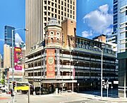
The People's Palace, built in 1910–1911.
-
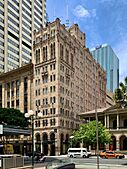
Manor Apartment Hotel, completed in 1931.
-
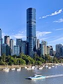
Brisbane Skytower, Brisbane's tallest building.


.jpg)

People and Culture of Brisbane
Who Lives in Brisbane?
| Birthplace | Population |
|---|---|
| Australia | 1,726,655 |
| New Zealand | 111,649 |
| England | 95,284 |
| India | 51,650 |
| Mainland China | 41,978 |
| Philippines | 27,907 |
| South Africa | 26,918 |
| Vietnam | 20,308 |
| South Korea | 13,305 |
| Taiwan | 12,826 |
| Scotland | 11,956 |
| Malaysia | 11,826 |
| Fiji | 10,800 |
| United States | 10,530 |
| Hong Kong SAR | 9,799 |
Brisbane is a very diverse city. At the 2021 census, about 20.7% of people in Brisbane were born overseas. The most common countries of birth for people from other countries were New Zealand, England, India, China, and the Philippines.
Many people in Brisbane have English, Australian, Irish, or Scottish backgrounds. About 3.0% of Brisbane's population identifies as Indigenous.
Languages Spoken
Most people in Brisbane speak English at home (77.3%). Other common languages include Mandarin, Vietnamese, Punjabi, and Cantonese.
Religions in Brisbane
At the 2021 census, the most common answer for religious belief was "No religion" (41.4%). For those who follow a religion, Christianity was the most popular (44.3%). The main Christian groups were Catholicism and Anglicanism. Brisbane's city center has two cathedrals: St John's (Anglican) and St Stephen's (Catholic).
Other popular religions include Hindu, Buddhist, and Muslim.
-
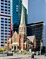
Albert Street Uniting Church.


Brisbane's Economy and Shopping
How Brisbane Makes Money

Brisbane is a major business center in Australia. It is strong in areas like mining, banking, insurance, transportation, information technology, and real estate. Many large Australian companies and international companies have offices in Brisbane.
The Port of Brisbane is a very important part of the city's economy. It is Australia's third-busiest port for the value of goods traded. It handles things like containers, sugar, grain, and coal.
Many people in Brisbane work in offices, in areas like IT, finance, education, and government. Other jobs, like petroleum refining and metalworking, are found in industrial areas near the port.
Tourism is also a big part of Brisbane's economy. Many people visit the city and use it as a starting point to explore other parts of Queensland. International students also contribute a lot, with over 95,000 students studying in Brisbane in 2018.
Shopping in Brisbane

The main shopping area in Brisbane's city center is the Queen Street Mall. This is Queensland's largest pedestrian mall. You can find many shopping centers here, like Uptown (formerly the Myer Centre) and QueensPlaza, which has luxury brands.
Outside the city center, there are many large indoor shopping centers. Some of the biggest include Westfield Chermside and Westfield Mt Gravatt.
Brisbane also has large wholesale markets, like the Brisbane Markets at Rocklea. Smaller markets are found in different parts of the city, like South Bank Parklands.
Culture and Sports in Brisbane
Arts and Entertainment

Brisbane has several art galleries. The largest are the Queensland Art Gallery and the Queensland Gallery of Modern Art (GOMA). GOMA is the biggest modern art gallery in Australia and hosts the Asia Pacific Triennial, which shows art from Asia and the Pacific. GOMA also has the Australian Cinémathèque, a special cinema that shows many different films for free.

You can watch plays and musical shows at the Queensland Performing Arts Centre (QPAC). The Brisbane Powerhouse and the Judith Wright Arts Centre also have art shows, music, and dance performances. Brisbane has many smaller theaters too.
QPAC is home to the Queensland Ballet, Opera Queensland, and the Queensland Symphony Orchestra. The Queensland Conservatorium also hosts music performances.

Brisbane has a lively music scene. Many famous musicians and bands come from Brisbane, including the Bee Gees, the Saints, the Go-Betweens, Savage Garden, and Powderfinger.

The State Library of Queensland is the biggest library in the state. Many films and TV shows have been made in Brisbane, including the popular children's animated series Bluey.
Brisbane has over 6,000 restaurants, and outdoor dining is very popular. You can find many types of food, including Japanese, Chinese, Italian, and Vietnamese. A local seafood called Moreton Bay bugs is often featured in the city's food.
Annual Events in Brisbane

- The Ekka (Royal Queensland Exhibition) is a big agricultural show held every August. It's the longest-running annual event in Brisbane.
- The Brisbane Festival happens every September. It includes Riverfire, one of Australia's largest fireworks displays, which attracts hundreds of thousands of people.
- The Brisbane International Film Festival (BIFF) shows new films from around the world.
- The Buddha Birth Day festival at South Bank is the largest of its kind in Australia.
- Other events include the Paniyiri Greek Festival and the Bridge to Brisbane fun run.
Sports in Brisbane


Brisbane has hosted many major sporting events, including the 1982 Commonwealth Games and events for the 2000 Sydney Olympics. It will host the 2032 Summer Olympics and 2032 Summer Paralympics.
Brisbane has professional teams in many sports:
- Rugby league: Brisbane Broncos and Dolphins (National Rugby League), and the Queensland Maroons (State of Origin).
- Rugby union: Queensland Reds (Super Rugby).
- Australian rules football: Brisbane Lions (Australian Football League).
- Soccer: Brisbane Roar FC (A-League).
- Cricket: Brisbane Heat (Big Bash League) and Queensland Bulls (Sheffield Shield).
The city's main stadiums are the Gabba (for cricket and Australian rules football) and Lang Park (for rugby league and rugby union).
Tourism and Fun in Brisbane

.jpg)
Brisbane is a very popular place for tourists. It's the third most visited city in Australia by international tourists.
Popular places to visit in Brisbane include:
- South Bank Parklands: With its beaches, gardens, and the Wheel of Brisbane.
- City Botanic Gardens and Roma Street Parkland: Beautiful green spaces in the city.
- Howard Smith Wharves: A lively area under the Story Bridge with restaurants.
- Queens Wharf: A new area with a casino and resort.
- City Hall: You can visit the Museum of Brisbane here.
- Story Bridge: You can even climb it for amazing views!
- Queensland Cultural Centre: Home to the Queensland Museum, Queensland Performing Arts Centre, and art galleries.
- Kangaroo Point Cliffs: Great for rock climbing and enjoying river views.

Outside the city center, you can visit:
- Lone Pine Koala Sanctuary: A great place to see koalas and other Australian animals.
- Mount Coot-tha: Offers amazing views of the city, a botanic garden, and a planetarium.
- Moreton Island: You can feed wild dolphins at Tangalooma resort.
- Fort Lytton National Park: A historic fort and museum.
- Beaches on the Redcliffe Peninsula and along Moreton Bay are popular for swimming, boating, and fishing.

Many national parks around Brisbane are great for hiking and bushwalking. These include D'Aguilar National Park and Glass House Mountains National Park.
Just south of Brisbane is the Gold Coast, famous for its surfing beaches and theme parks. To the north is the Sunshine Coast, also known for its beautiful beaches. Both are popular day trips for people from Brisbane.
In 2015, Brisbane was named one of the top ten most beautiful cities in the world by Rough Guides. They praised its mix of modern buildings, green spaces, and the winding Brisbane River.
How Brisbane is Governed


A large part of Brisbane is managed by one local government area called the City of Brisbane. This is the largest local government in Australia by population and budget. It covers over 40% of the greater Brisbane area. Other parts of Brisbane are in different local government areas like Logan City and City of Moreton Bay.
Each local government area has a directly elected mayor, like the Lord Mayor of Brisbane, and a council of elected members. Brisbane City Hall is where the Brisbane City Council meets.


As the capital of Queensland, Brisbane is home to the Parliament of Queensland at Parliament House. This is where the state's laws are made. The Governor of Queensland lives at Government House.
Education in Brisbane

Brisbane has three main universities:
- The University of Queensland (UQ): Queensland's oldest university, often ranked among the world's top 50.
- Queensland University of Technology (QUT): With campuses in the city center and Kelvin Grove.
- Griffith University (GU): With several campuses in Brisbane.

Many international students come to Brisbane to study. In 2018, over 95,000 international students were enrolled in universities and colleges in the City of Brisbane area. Most of these students come from China, India, and other countries in Asia.
Brisbane also has several TAFE colleges, which offer vocational training. There are many other private colleges for different subjects.
Most schools in Brisbane are run by the Queensland Government. There are also many independent (private) and Catholic schools.
Brisbane's Infrastructure
Getting Around Brisbane
Brisbane has a large transport network. Most people use private cars, but there are also trains, buses, and ferries. All public transport is managed by Translink, which uses a special card called a go card for payment.
Roads and Tunnels
.jpg)
Brisbane has a big network of highways and motorways. The Pacific Motorway connects the city to the Gold Coast and New South Wales. The city also has several long road tunnels, like the Clem Jones Tunnel and the Airport Link tunnel. These tunnels help reduce traffic in the city center.
Bridges
.jpg)
The Brisbane River has 16 bridges crossing it, mostly in the inner city. Famous road bridges include the Story Bridge and the William Jolly Bridge. There are also bridges just for trains and three bridges just for pedestrians and cyclists, like the Goodwill Bridge and the Kurilpa Bridge.
Trains

Brisbane's train network has 154 stations and 13 lines. It connects the city to the Gold Coast and Sunshine Coast. Over 55 million passenger trips were made on the trains in 2018–19. A new project called Cross River Rail is building twin tunnels under the Brisbane River to add new train stations.
Buses

Brisbane has a large busway network, which are special roads just for buses. The main bus hubs are at King George Square and Queen Street. There are also many local bus routes. The Brisbane Metro project is building new bus rapid transit routes that will open in 2024.
Ferries
_in_January_2019_in_Brisbane.jpg)
RiverCity Ferries operates three types of ferry services on the Brisbane River:
- CityCat: Fast catamaran ferries popular with tourists and commuters.
- Cross River: Smaller ferries for short trips across the river.
- CityHopper: A free service that stops at popular spots along the river.
Walking and Cycling
Brisbane has a large network of paths for walking and cycling along the Brisbane River, called the Riverwalk. Some parts of the Riverwalk are built over the river itself.
Airports

Brisbane Airport is the city's main airport and the third busiest in Australia. It handles both domestic and international flights. You can take the Airtrain service directly from the airport to the city center.
Seaport

The Port of Brisbane is located at the mouth of the Brisbane River. It is Australia's third-busiest seaport for the value of goods. It has many berths for container ships and other cargo.
Brisbane also has two cruise ship terminals. The Brisbane International Cruise Terminal can handle the largest cruise ships in the world.
Healthcare

Brisbane has many hospitals, both public and private. The Royal Brisbane and Women's Hospital and the Princess Alexandra Hospital are two of Queensland's largest hospitals. The Queensland Children's Hospital is a major hospital for kids.
Other Services

Water for Brisbane is stored in three major dams: Wivenhoe, Somerset, and North Pine. Electricity and gas are supplied by various companies.
Brisbane has many cemeteries, including the large and historic Toowong Cemetery, which opened in 1875.
Media in Brisbane
Newspapers
Brisbane's main local newspapers are The Courier-Mail and The Sunday Mail. The Brisbane Times is another major news source, available online.
Television

Brisbane receives all five major Australian television networks: Seven, Nine, Ten, ABC, and SBS. These channels broadcast from towers on Mount Coot-tha. Pay TV services like Optus and Foxtel are also available.
Radio
Brisbane has many public and commercial radio stations. Public stations include ABC Radio Brisbane (local news and talk) and Triple J (alternative music). Commercial stations include 4BC (talk), B105 (pop), and Nova 106.9 (top 40). There are also many community radio stations that play different types of music and broadcast in various languages.
Sister Cities
Brisbane has sister city relationships with several cities around the world:
 Abu Dhabi, United Arab Emirates
 Auckland, New Zealand
 Chongqing, China
 Daejeon, South Korea
 Hyderabad, India
 Kaohsiung, Taiwan
 Kobe, Japan
- Sapporo, Japan
 Seattle, United States
 Semarang, Indonesia
- Shenzhen, China
See also
 In Spanish: Brisbane para niños
