
Moreton Island facts for kids
|
Native name:
Mulgumpin
|
|
|---|---|

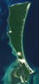
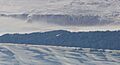
Moreton Island satellite image
|
|

Moreton Island
Location in Queensland
Location of Moreton Island in Queensland
|
|
| Geography | |
| Location | Coral Sea; Moreton Bay |
| Coordinates | 27°10′S 153°24′E / 27.167°S 153.400°E |
| Area | 186 km2 (72 sq mi) |
| Length | 44 km (27.3 mi) |
| Width | 13 km (8.1 mi) |
| Highest elevation | 280 m (920 ft) |
| Highest point | Mount Tempest |
| Administration | |
|
Australia
|
|
| State | Queensland |
| Region | South East Queensland |
| Local government area | City of Brisbane |
| Demographics | |
| Population | 298 (2011 census) |
Moreton Island, also known as Mulgumpin, is a beautiful island located in Moreton Bay off the coast of South East Queensland, Australia. The Coral Sea is on its eastern side. This amazing island is about 58 kilometres (36 mi) northeast of Brisbane, the capital city of Queensland.
Moreton Island is a very special place because 98% of it is a national park. It's a popular spot for people to visit for a day trip, go four-wheel driving, camping, fishing, and even whale watching! You can get there by ferry from Brisbane in about 75 minutes. It is the third largest sand island in the world. Together with Fraser Island, Moreton Island forms the biggest sand structure on Earth.
Before European settlement, Moreton Island was the traditional home of the Ngugi Aboriginal tribe. Today, the island is part of the City of Brisbane. It has four small communities: Bulwer, Cowan Cowan, and Kooringal. Most of the island is simply called the locality of Moreton Island. The private Tangalooma Island Resort is also on the island. All the places where people live are on the western side of the island, facing Moreton Bay.
The island was named by an explorer named Matthew Flinders. There have been at least five lighthouses built on the island over time. A small number of people live in the island's four small towns. Tangalooma used to be a place where whales were processed. You can reach the island by a special ferry that carries vehicles or by a passenger ferry. Moreton Island is a fantastic spot for camping and fishing adventures.
Moreton Island is one of the wettest places in the City of Brisbane. Rain falls pretty evenly throughout the year, unlike some other parts of South East Queensland. Cape Moreton, at the northern tip, gets about 1,567 millimetres (61.7 in) of rain each year.
Contents
Exploring Moreton Island's Geography
Moreton Island covers an area of about 186 square kilometres (72 sq mi). It stretches for 37 kilometres (23 mi) from north to south and is 13 kilometres (8.1 mi) wide at its broadest point. Cape Moreton, located at the island's northeastern tip, is the only place on the island where you'll find rocks instead of sand. Captain James Cook named it Cape Morton in May 1770, thinking it was part of the mainland. The spelling changed to "Moreton" later due to a mistake.
The highest point on the island is Mount Tempest. It stands at 280 metres (920 ft) high and is thought to be the tallest stable coastal sandhill in the world! Close by is another large sandhill called Storm Mountain, which is 264 metres (866 ft) high. You'll find tall, curved sand dunes running along the middle of the island. Behind the beaches, there are many "sand blow-outs." These happen when strong winds blow sand inland after the natural plants on the dunes are disturbed.
Moreton Island also has several freshwater lakes. Some are "perched lakes," which means they sit above the main water table, and others are "window lakes," where the land dips down to the water table. As rainwater fills the ground beneath the island, these large lakes form. Blue Lagoon is the biggest and most popular lake on the eastern side of the island. Honeyeater Lake, known for its many birds, is a smaller lake near Blue Lagoon. Dolphin Lake, near Tangalooma, got its name because it looks like a wild dolphin. The smallest and most impressive lake is Lake Trusiak, near Bulwer, named after a Polish adventurer.
Island Communities and Access Points
There are four small communities on the western side of Moreton Island. The northernmost one is Bulwer, located near the island's northwestern corner. About 4.5 kilometres (2.8 mi) south of Bulwer is Cowan Cowan. Around 6 kilometres (3.7 mi) further south, you'll find the private Tangalooma Island Resort. This resort used to be a whaling station. Today, it has the Tangalooma Marine Education and Conservation Centre (TMECC) and is famous for its dolphin feeding and wreck diving experiences. Tangalooma is the main way to get to the island, with regular passenger ferries and vehicle barges. The island's main airstrip, which is 1,000 metres (3,300 ft) long, is located between Cowan Cowan and Tangalooma.
The other community is Kooringal, near the southern tip of the island. Kooringal has its own 500 metres (1,600 ft) airstrip. A vehicle barge called the Amity Trader now connects Kooringal to Amity Point on North Stradbroke Island.
North of Cape Cowan Cowan, you can find Fort Cowan Cowan. This was an old World War II bunker and fortification complex. It was built to protect the entrance to Moreton Bay. The narrow waterway between Moreton Island and North Stradbroke Island is called South Passage. It can be dangerous to cross when the seas are rough.
Moreton Island's Climate
Moreton Island has a humid subtropical climate. This means it has very warm and humid summers, and mild, pleasant winters. It rains a lot throughout the year, with an average of 1,467.3 millimetres (57.77 in) of rain annually. The island also experiences strong winds, averaging 26.8 kilometres per hour (16.7 mph) in the afternoon, partly because it's so open to the ocean.
| Climate data for Moreton Island (27º01'48"S, 153º28'12"E, 100 m AMSL) (1910-2024 normals and extremes, rainfall 1869-2024) | |||||||||||||
|---|---|---|---|---|---|---|---|---|---|---|---|---|---|
| Month | Jan | Feb | Mar | Apr | May | Jun | Jul | Aug | Sep | Oct | Nov | Dec | Year |
| Record high °C (°F) | 33.1 (91.6) |
33.0 (91.4) |
32.8 (91.0) |
30.2 (86.4) |
28.9 (84.0) |
25.6 (78.1) |
25.3 (77.5) |
27.3 (81.1) |
30.0 (86.0) |
32.3 (90.1) |
33.4 (92.1) |
35.4 (95.7) |
35.4 (95.7) |
| Mean daily maximum °C (°F) | 27.1 (80.8) |
27.0 (80.6) |
26.2 (79.2) |
24.4 (75.9) |
21.9 (71.4) |
19.7 (67.5) |
19.1 (66.4) |
19.9 (67.8) |
21.6 (70.9) |
23.2 (73.8) |
24.8 (76.6) |
26.2 (79.2) |
23.4 (74.2) |
| Mean daily minimum °C (°F) | 22.0 (71.6) |
22.1 (71.8) |
21.3 (70.3) |
19.2 (66.6) |
16.5 (61.7) |
14.2 (57.6) |
13.3 (55.9) |
14.0 (57.2) |
16.0 (60.8) |
17.9 (64.2) |
19.6 (67.3) |
21.0 (69.8) |
18.1 (64.6) |
| Record low °C (°F) | 13.9 (57.0) |
14.6 (58.3) |
14.4 (57.9) |
10.6 (51.1) |
8.0 (46.4) |
6.1 (43.0) |
5.6 (42.1) |
6.1 (43.0) |
6.1 (43.0) |
9.4 (48.9) |
9.2 (48.6) |
12.2 (54.0) |
5.6 (42.1) |
| Average precipitation mm (inches) | 146.8 (5.78) |
157.0 (6.18) |
176.6 (6.95) |
142.5 (5.61) |
165.2 (6.50) |
133.2 (5.24) |
112.4 (4.43) |
74.7 (2.94) |
63.2 (2.49) |
79.4 (3.13) |
91.0 (3.58) |
125.8 (4.95) |
1,467.3 (57.77) |
| Average precipitation days (≥ 1.0 mm) | 8.8 | 9.8 | 11.2 | 10.7 | 10.9 | 8.8 | 7.9 | 6.5 | 5.9 | 6.6 | 6.7 | 7.9 | 101.7 |
| Average afternoon relative humidity (%) | 74 | 75 | 74 | 71 | 69 | 67 | 64 | 63 | 66 | 71 | 73 | 74 | 70 |
| Average dew point °C (°F) | 20.3 (68.5) |
20.5 (68.9) |
19.5 (67.1) |
17.1 (62.8) |
14.5 (58.1) |
11.9 (53.4) |
10.4 (50.7) |
10.8 (51.4) |
13.2 (55.8) |
15.5 (59.9) |
17.6 (63.7) |
19.4 (66.9) |
15.9 (60.6) |
| Source: Bureau of Meteorology (1910-2024 normals and extremes, rainfall 1869-2024) | |||||||||||||
Moreton Island's Rich History
Moreton Island is the traditional home of the Ngugi tribe. Many shell middens (piles of shells left by Aboriginal people) on the island show that Aboriginal people lived here for at least 2000 years. Captain James Cook named the main headland "Cape Morton" on May 17, 1770. However, due to a clerical error, people later started using "Moreton." Matthew Flinders then named the island after the Cape on July 31, 1799.
In March and April 1823, three castaways named Thomas Pamphlett, John Finnegan, and Richard Parsons traveled across the island before going to the mainland. The Ngugi people, who were about 100 strong, along with the Nunukul people from North Stradbroke Island, sometimes had conflicts with the European settlers.
European settlers arrived on the island in 1848 after a ship called the Sovereign was wrecked there. A pilot station (a place where pilots guide ships) was set up at Bulwer and operated until 1909. Another ship, the clipper Young Australia, was wrecked on Moreton Island in 1872.

At Cape Moreton, you'll find Queensland's oldest lighthouse, Cape Moreton Light, which first shone its light in 1857. After this, at least four other lighthouses were built on the island. During World War II, the Royal Australian Navy and Australian Army set up defense buildings on the island. These included anti-aircraft guns and mine control centers. Their job was to protect the entrance to the port of Brisbane. At its busiest, 900 soldiers were stationed on the island.
From 1952 to 1962, Tangalooma was the only whaling station in Queensland. Humpback whales were caught during their yearly journey north. Each season, up to 600 whales were processed, sometimes as many as 11 whales in a single day. The site of the whaling station is now the Tangalooma Island Resort. You can still see parts of the old whaling station at the resort.
Moreton Island became part of the Greater Brisbane area in 1974. At first, the local council allowed 60% of the island to be used for sand mining. However, after many people protested, the council changed the rules to protect the island as open space. The sand on the island contains valuable minerals like rutile and zircon. The Queensland Government, led by Joh Bjelke-Petersen, supported sand mining. A report was created that suggested 94% of the island should be protected from mining. Despite this, more mining licenses were given out until 1984. That's when the Australian Federal government decided not to allow the export of minerals from the island's sands. Finally, in 1989, the Premier of Queensland, Wayne Goss, stopped all mining on the island and paid money to the companies involved.
A saltwater lagoon on the island was once a temporary home for a dugong named Pig. Pig was the youngest dugong ever successfully raised in human care. The dugong was placed in the lagoon to help it learn natural instincts before being released into the wild.
The 2009 Oil Spill Incident
On March 11, 2009, a container ship called the MV Pacific Adventurer lost some of its fuel oil and cargo north of Moreton Island. This happened during very rough seas caused by Tropical Cyclone Hamish. The ship reportedly lost 31 containers of ammonium nitrate and up to 230 tonnes of fuel oil. This spilled oil washed up on beaches along the northern part of Moreton Island, including Honeymoon Bay, as well as on Bribie Island and beaches on the Sunshine Coast. These areas were declared disaster zones.
The ship's owners faced large fines and were responsible for the environmental damage. The company later stated that a diver's inspection showed "significantly more" oil had spilled than first thought.

Native Title Recognition for the Quandamooka People
The Quandamooka people were officially recognized as the traditional owners of Mulgumpin (Moreton Island) on November 27, 2019. This recognition means that the Quandamooka Yoolooburrabee Aboriginal Corporation now shares responsibility for managing the national park, including booking campsites.
Heritage-Listed Sites on Moreton Island
Moreton Island has several places that are protected because of their historical importance:
- Cape Moreton: Cape Moreton Lightstation
- 25 Dorothy Newnham Street: Signal Station, Moreton Island
- 30 Jessie Wadsworth Street: Fort Cowan Cowan (Cowan Cowan Battery)
The island was also listed in 1981 on the now-closed Register of the National Estate, which recognized important places in Australia.
Fun Activities and Recreation

Moreton Island is a fantastic place for outdoor adventures! In 1966, 98% of the island became the Moreton Island National Park. This park is managed by the Queensland Parks and Wildlife Service.

You can go camping and four-wheel driving in many parts of the island, but you need to pay a fee and get a permit. You can only bring four-wheel drive vehicles to the island by ferry because there are no paved roads. All the roads are sandy tracks.
There are tons of fun things to do, like sand tobogganing, which Moreton Island is famous for! You can also go snorkeling and diving, watch birds, feed dolphins, spot whales from the land, go fishing, and even try parasailing.
Moreton Island is part of a chain of sand islands. To the south, you'll find South Stradbroke Island and North Stradbroke Island. To the north are Bribie Island and Fraser Island, which is known as the biggest sand island in the world. Moreton Island is the third largest.
Managing the Island for Everyone
The Queensland Government started a new plan for Moreton Island called the Moreton Island Management Plan on July 1, 2007. This plan includes a new system for booking campsites and special routes for quad bikes, trikes, and trail bikes. It also sets up different zones with rules for how people can access and enjoy the island. The plan also includes ways to manage fires, control pests and plants, and remove feral animals.
Getting to Moreton Island
You can get to Moreton Island by vehicle ferry from the Moreton Island Adventures MICAT at the Port of Brisbane in Lytton. There are also passenger ferry services from the Tangalooma Island Resort Fleet, which leave from the Brisbane River at Holt St Pinkenba.
There are no public bus services on the island. However, you can take tours and taxi transfers using four-wheel drive vehicles from Bulwer. If you bring your own private vehicle, it must be a four-wheel drive because the roads are unsealed and very sandy. You also need a vehicle access permit since the island is a national park. There is very little or no petrol available on the island, so make sure you have enough fuel!
Images for kids
-
Moreton Island satellite image
-
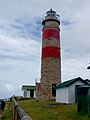
Cape Moreton Light, Queensland's oldest lighthouse
-
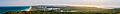
Panorama of the island viewed from the Moreton Island lighthouse
-
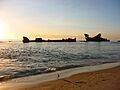
Several shipwrecks provide a safe snorkelling spot at Tangalooma. They were placed there as a breakwater
-
Large sand cliff showing sand rivers running
See also
 In Spanish: Isla Moreton para niños
