
Lytton, Queensland facts for kids
Quick facts for kids LyttonBrisbane, Queensland |
|||||||||||||||
|---|---|---|---|---|---|---|---|---|---|---|---|---|---|---|---|

Fort Lytton with Brisbane River in background
|
|||||||||||||||

Lytton
Location in Queensland
|
|||||||||||||||
| Population | 0 (2021 census) | ||||||||||||||
| • Density | 0/km2 (0/sq mi) | ||||||||||||||
| Postcode(s) | 4178 | ||||||||||||||
| Area | 6.9 km2 (2.7 sq mi) | ||||||||||||||
| Time zone | AEST (UTC+10:00) | ||||||||||||||
| Location | 20.1 km (12 mi) ENE of Brisbane CBD | ||||||||||||||
| LGA(s) | City of Brisbane (Wynnum Manly Ward) | ||||||||||||||
| State electorate(s) | Lytton | ||||||||||||||
| Federal Division(s) | Bonner | ||||||||||||||
|
|||||||||||||||
Lytton is a suburb located on the river in the City of Brisbane, Queensland, Australia. It's known for being an important historical area. In the 2021 census, Lytton had almost no people living there.
This area became a key naval base after Fort Lytton was built between 1880 and 1881. The Fort was very important for protecting the city and its shipping routes. It helped keep Brisbane safe from possible attacks during the time when Australia was a colony.
Contents
Exploring Lytton's Location
Lytton is bordered by the Brisbane River to its north-west side. It is about 13 kilometres (8.1 mi) east of the main city centre of Brisbane CBD. However, getting there by train or road takes a bit longer.
You can find Lytton Hill in the north-east part of the suburb. This hill stands about 26 metres (85 ft) above sea level. There's also a dry lake called Clunie Flats in the western part of Lytton.
A Look Back at Lytton's Past
A special station for ship pilots and a small village were set up in Lytton in 1859. The area was likely named after Edward Bulwer-Lytton, who was an important government official in 1858–59.
A few years later, in 1862, a telegraph line was built from Brisbane to Lytton. This helped people send messages quickly.
The "Prosperine" Reformatory Ship
For a while, a old ship called the "Prosperine" was used as a floating school for boys. From 1871 to 1879, boys on the ship were taught by a special instructor. Later, a qualified teacher was sent to the ship. This school was also known as the Lytton Stockade School. In 1900, the school moved to a place called Westbrook.
Fort Lytton: Protecting the River
Because of its perfect spot at the mouth of the Brisbane River, Fort Lytton was built in 1881. Its job was to guard the river entrance. The fort was shaped like a five-sided star and was hidden behind a large dirt wall. It even had a moat around it! The fort was equipped with powerful guns that could disappear after firing, making them hard to spot. A rifle range was also added in 1881.
Lytton State School's Journey
Lytton State School first opened its doors on September 18, 1882. It started with 41 students and its first teacher was Mr A. S. Spencer. The school was located on a hill with a view of the sea. In 1911, the school buildings were moved to Wynnum North and the school changed its name to Wynnum North State School. This school later closed in 2010 and the land was used for new apartments.
Important Historical Places
Lytton has several places that are listed as important heritage sites. This means they are protected because of their historical value. These include:
- Heavy Anti-Aircraft Gun Station 385
- Lytton Hill
- Fort Lytton
- The former Lytton Quarantine Station
Lytton Today: Industry and Business
Even though Lytton was once a small town, it is now mostly used for businesses and factories. It shares the same postcode as the Port of Brisbane, which is a very busy port. Ampol owns and runs the Lytton Oil Refinery in the north-east of the suburb. This refinery can produce a huge amount of oil every day.
Local Facilities
The Wynnum Wastewater Treatment Plant is located in Lytton. This plant cleans water before it is released into Crab Creek, which then flows into Moreton Bay.
Parks and Green Spaces
Lytton also has a few parks where people can enjoy the outdoors:
- Constellation Way Park
- Pritchard Street Park
- Sandy Camp Park
Gallery
-
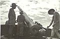
1943-11-11. Gun drill at Lytton. Left to right H. G. Brigg, A. T. Llewellan, B. F. Williams.
-
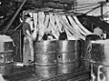
Rope works on Lytton road.
-
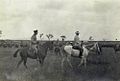
Lord Chelmsford inspecting the Light Horse camp at Lytton, April 1908


