
Brisbane central business district facts for kids
Quick facts for kids Brisbane CBDBrisbane, Queensland |
|||||||||||||||
|---|---|---|---|---|---|---|---|---|---|---|---|---|---|---|---|

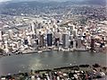
Brisbane CBD, looking across the Brisbane River from South Brisbane, 2020
|
|||||||||||||||

Brisbane CBD
Location in Queensland
|
|||||||||||||||
| Population | 12,587 (2021 census) | ||||||||||||||
| • Density | 5,030/km2 (13,000/sq mi) | ||||||||||||||
| Established | 1825 | ||||||||||||||
| Postcode(s) | 4000 | ||||||||||||||
| Area | 2.5 km2 (1.0 sq mi) | ||||||||||||||
| Time zone | AEST (UTC+10:00) | ||||||||||||||
| LGA(s) | City of Brisbane (Central Ward) |
||||||||||||||
| County | Stanley | ||||||||||||||
| Parish | North Brisbane | ||||||||||||||
| State electorate(s) | McConnel | ||||||||||||||
| Federal Division(s) | Brisbane | ||||||||||||||
|
|||||||||||||||

Brisbane City is the main part of Brisbane, the capital city of Queensland, Australia. People often call it the "Brisbane CBD" or just "the city". It sits on the northern bank of the Brisbane River. This area was historically known as Meanjin by the local Yuggera people.
The city area is shaped like a triangle. It is surrounded by the Brisbane River on three sides. This point, called Gardens Point, gently rises towards the north-west. Here, you'll find parks and the nearby suburb of Spring Hill. To the north-east, the city borders Fortitude Valley. To the west, it meets Milton, Petrie Terrace, and Kelvin Grove.
In 2021, about 12,587 people lived in Brisbane City.
Template:TOC limit=3
Contents
Exploring Brisbane's City Centre
The Brisbane central business district (CBD) is full of tall buildings. You can also find many green spaces here. Some popular parks include Roma Street Parklands, City Botanic Gardens, and Wickham Park. The city covers an area of about 1.37 square kilometers.
The city's streets follow a grid pattern. This design was made when the city was first settled. It is a common feature in many Australian cities.
Street Names and Famous Squares
Many streets in the city are named after members of the House of Hanover, a royal family. Queen Street is the main street. It is named after Queen Victoria. This street has a large walking area called the Queen Street Mall.
Streets named after royal women run parallel to Queen Street. These include Adelaide, Alice, Ann, Charlotte, Elizabeth, Margaret, and Mary. Streets named after royal men cross these streets. They are Albert, Edward, George, and William.
The city also has several public squares. These include King George Square, Post Office Square, and ANZAC Square. ANZAC Square has the city's main war memorial.
The Brisbane CBD was built on a hill from the Taylor Range. The highest point is Wickham Terrace. North Quay was an important landing spot. It was used when Europeans first explored the Brisbane River.
Petrie Bight: A River Bend
Petrie Bight is a bend in the Brisbane River. This area is located under the northern end of the Story Bridge. It stretches around the river to Admiralty Towers II. This spot was once called Petrie Gardens. It was an early farm that grew food for the first settlers.
The area is named after Andrew Petrie. It has been used by water police and for wharves (docks) in the past. Its location downstream from the city centre made it perfect for ships and boats.
A Glimpse into History
Brisbane City has a rich history. Many important events happened here.
In 1860, the Queensland Government opened its first school. It was called the Brisbane National School. It started in Adelaide Street with 50 boys and 8 girls.
The Brisbane City Library opened in 1965. In 2006, it moved to Brisbane Square.
The city centre was affected by the floods in 2010-2011.
Who Lives in Brisbane City?

In 2016, 9,460 people lived in Brisbane City. Many people living here were born outside Australia. The most common countries of birth were China (16.0%), South Korea (8.3%), and England (3.7%).
About 43.7% of people spoke only English at home. Other languages included Mandarin (12.3%), Korean (7.7%), and Cantonese (3.6%). For religion, 43.0% said they had no religion. About 16.8% were Catholic.
By 2021, the population of Brisbane City had grown to 12,587 people.
Learning in the City
There are no schools directly inside the central business district. However, there are schools very close by.
- The nearest government primary schools are Brisbane Central State School in Spring Hill and Petrie Terrace State School in Petrie Terrace.
- The nearest government secondary schools are Fortitude Valley State Secondary College in Fortitude Valley and Kelvin Grove State College in Kelvin Grove.
Queensland University of Technology (QUT) has a large campus at Gardens Point. This campus is located between Parliament House, the City Botanic Gardens, and the Brisbane River. QUT has an art gallery and a museum at Old Government House. These places are open to the public.
Other universities also have offices in the Brisbane CBD. They use these for events and short courses. However, their main teaching and research buildings are usually elsewhere.
Famous Buildings and Areas


Before 1964, there was a rule that limited building heights to about 40 meters. After this rule changed, taller buildings started to appear. Some of the first skyscrapers were the SGIO building (now Suncorp Plaza) in 1970 and AMP Place in 1977.
Brisbane is now home to some of Australia's tallest buildings. These include:
- Brisbane Skytower (270 meters)
- The One (264 meters)
- One William Street (260 meters)
- Soleil (243 meters)
- Aurora Tower (207 meters)
- Riparian Plaza (200 meters)
- One One One Eagle Street (195 meters)
- Infinity (249 meters), finished in 2014.
The Brisbane CBD is a major business centre in Australia. It has many tall office buildings. These buildings are used by companies and all levels of government. Different areas of the city have special uses:
- The areas around the Queen Street Mall and Adelaide Street are mainly for shopping.
- A legal area exists around the court buildings. These are found near the intersections of George Street, Adelaide Street, and Ann Street.
- The government area used to be around the Executive Building. Now, 1 William Street, completed in 2016, serves as the main government office.
A big city improvement project, called Queen's Wharf, is being built. It includes a new bridge for walkers over the Riverside Expressway.
Office Space in the City
.jpg)
Brisbane's CBD has a lot of office space. In early 2008, there were 1.7 million square meters of office space. At that time, almost all of it was rented out.
However, by mid-2013, the amount of empty office space had increased. This meant fewer businesses were renting offices.
What to See and Do

The Brisbane CBD has many famous places to visit:
- City Hall: This building also houses the Museum of Brisbane.
- The Story Bridge: A well-known landmark.
- The Howard Smith Wharves: A popular spot with restaurants and entertainment.
- ANZAC Square: Home to the city's war memorial.
- St John's Cathedral: A beautiful church.
- The Brisbane River and its Riverwalk: Paths along the river for walking and cycling.
- The City Botanic Gardens: A large, peaceful park.
- Roma Street Parkland: Another beautiful park.
- Queensland Parliament House: Where the state government meets.
- Old Government House: A historic building.
- Customs House: A grand old building by the river.
Historic Places

Brisbane has many places that are protected for their history. These are called heritage-listed sites. They include:
- Several buildings on Adelaide Street.
- Many properties on Albert Street.
- Historic sites on Alice Street.
- Various buildings on Ann Street.
- Howard Smith Wharves on Boundary Street.
- Properties on Charlotte Street.
- The Coronation Drive retaining wall.
- Roma Street railway station at 15 Countess Street.
- Several properties on Creek Street.
- Mooney Memorial Fountain at 118 Eagle Street.
- Eagle Street Fig Trees at 118A Eagle Street.
- Riverside Centre at 123 Eagle Street.
- Many properties on Edward Street.
- Various sites on Elizabeth Street.
- Properties on Margaret Street.
- Wenley House at 20–30 Market Street.
- Several properties on Mary Street.
- Various sites on North Quay.
- Many properties on Queen Street.
- First Brisbane Burial Ground on Skew Street.
- William Jolly Bridge on Skew Street.
- Brisbane Dental Hospital and College at 168 Turbot Street.
- King Edward Park Air Raid Shelter at 224 Turbot Street.
- Hellesvere at 436 Upper Roma Street.
- Several properties on William Street.
Getting Around Brisbane City
The Brisbane CBD is a central point for all public transport.
Road and Bridges
Four road bridges connect the CBD to the southern side of the Brisbane River. These are the Captain Cook Bridge, the Victoria Bridge, the William Jolly Bridge, and the Go Between Bridge. The Story Bridge links Fortitude Valley with Kangaroo Point. It also provides access to the city from the southern bank.
The Captain Cook Bridge connects the Pacific Motorway to the Riverside Expressway. The Clem Jones Tunnel goes under the CBD, helping traffic bypass the city centre. Parking on the street is very popular, so you will find parking meters everywhere.
Walking and Cycling
The Goodwill Bridge allows people to walk or cycle across the river to South Bank. The Kurilpa Bridge connects North Quay to South Brisbane for walkers and cyclists. You can also walk or cycle across the Victoria, William Jolly, Go Between, and Story road bridges. A new bridge, the Kangaroo Point Green Bridge, is being built between the CBD and Kangaroo Point.
Public Transport Hub

The Brisbane CBD is the main hub for all public transport in Brisbane.
- Buses: Bus services are centred at the Queen Street bus station and King George Square busway station.
- Trains: Suburban train services pass through Central railway station and Roma Street railway station. Roma Street also serves as the station for long-distance trains.
- Ferries: The city is served by various ferries. Brisbane's CityCat high-speed ferry service is popular. It travels along the Brisbane River, stopping at several CBD wharves.
The Brisbane Riverwalk is a path for walkers and cyclists. It runs along the river bank next to the central business district.
Images for kids
-
Brisbane CBD and the Brisbane River, as seen from Kangaroo Point, 1989

