
Moreton Bay facts for kids
Quick facts for kids Moreton Bay |
|
|---|---|

Moreton Bay and the Brisbane metropolitan area
|
|

Moreton Bay
Location in Queensland
|
|

Location of Moreton Bay in South East Queensland
|
|
| Location | South East Queensland |
| Coordinates | 27°15′S 153°15′E / 27.250°S 153.250°E |
| Native name | Quandamooka |
| Etymology | In honour of Lord Morton |
| River sources | |
| Ocean/sea sources | Coral Sea |
| Catchment area | 21,220 km2 (8,190 sq mi) |
| Basin countries | Australia |
| Max. length | 125 km (78 mi) |
| Max. width | 35 km (22 mi) |
| Surface area | 1,523 km2 (588 sq mi) |
| Average depth | 6.8 m (22 ft) |
| Frozen | never |
| Islands | |
| Settlements | Brisbane |
| Designated: | 22 October 1993 |
| Reference #: | 631 |
Moreton Bay is a large bay on the eastern coast of Australia, about 14 kilometers from central Brisbane, Queensland. It is one of Queensland's most important coastal areas. The calm waters of Moreton Bay are a popular spot for fishing and for businesses that catch seafood.
The Port of Brisbane handles many ships that travel through the bay's shipping channel. This channel helps ships reach the airport safely and reduces noise over the city. Many ferries and water taxis also use the bay for transport.
Moreton Bay has a rich history, including times of conflict between the Quandamooka people and early European settlers. It is home to important natural places and large areas of sandbanks. It is also the only place in Australia where dugongs gather in large groups. Many parts of the mainland coast and southern islands have towns and homes.
The bay's waters are usually calm because Moreton Island and North Stradbroke Island protect it from big ocean waves. In 2009, Moreton Bay was named one of Queensland's "Q150 Icons" for being a "Natural attraction." It is also known as a Pacific Ocean "Hope Spot," which means it's a special place for marine life.
Contents
History of Moreton Bay
Early Times
Moreton Bay was formed about 6,000 years ago when sea levels rose and covered the old floodplains of the Brisbane River. The Quandamooka people lived on Moreton Bay and its islands for thousands of years. They had a very rich way of life, gathering lots of natural foods. Important foods for trade and ceremonies included huge oyster beds, the yearly mullet fish catch, and bunya nuts. People would travel to the coast or inland each year to enjoy these foods.
In 1823, explorer John Uniacke wrote about the importance of fish, kangaroo, and a fern-root called dingowa in the local tribes' diet. He also wrote about fights between different tribes near Bribie Island, which were seen by shipwreck survivors.
By the 1840s, it was thought that about 4,000 Aboriginal people lived in the area. However, between 1850 and 1855, about 3,000 European settlers arrived, changing the population balance.
European Exploration and Settlement
Captain Cook named the area Morton's Bay on May 15, 1770, after Lord Morton. The spelling "Moreton" was a mistake in the first book about Cook's journey. Cook only named the outer part of the bay, not the inner area we know today.
Matthew Flinders was the first European to enter the bay in 1799. He landed at Pumicestone Passage, Redcliffe, and Coochiemudlo Island. Later, in 1823, John Oxley explored the Brisbane River. The next year, Oxley started the first European settlement in the bay at what is now Redcliffe.
After 1823, more convicts and soldiers arrived. Because the South Passage between Moreton and Stradbroke Islands was the shortest shipping route, a supply station and pilot station were set up at Amity Point in 1825.
Serious European settlement began after the Redcliffe settlement was moved. Work started on a new convict settlement up the Brisbane River in 1825. This new settlement grew quickly, and more ships came into the bay. To help the pilot station at Amity, convicts were sent to Dunwich in 1827 to build a new road. The first permanent European settlement at Dunwich was built within a year. However, due to bad weather, smuggling, and conflicts with Aboriginal people, this convict outpost closed in 1831.
The first ship carrying free immigrants from England, the Artemisia, arrived in Moreton Bay in December 1848. The next year, the Fortitude brought even more free immigrants.
By the 1850s, the bay was used to transport timber. Logs were floated down rivers and then tied together into rafts. These rafts were moved by the bay's currents or by boats to the Brisbane River or Dunwich to be shipped to Sydney.
The Lightship Rose helped guide ships at the mouth of the Brisbane River. The SS John Oxley was another important boat that sometimes acted as a pilot ship.
Car ferries started crossing the bay to North Stradbroke Island in 1947, which led to more tourists visiting the island. In the 1950s, sand mining began, and the first land was sold at Point Lookout.
Sadly, on September 1, 2007, four people died in a boat accident on the bay, near the Pinkenba boat ramp. Ten others were injured.
Moreton Bay has at least 102 shipwrecks, but only 26 of them have their exact location known.
European Contact with Local Indigenous People
Problems arose when the new European settlers did not respect Aboriginal customs. This caused difficulties and conflicts.
In 1843, Catholic missionaries chose Dunwich for the first Catholic mission to Australian Aboriginal people. A quarantine station on Stradbroke Island from 1850 to the 1870s meant that farming or wider settlement was not encouraged, to prevent the spread of disease.
Because of this, European use of Quandamooka land in the 1800s was mostly limited to government buildings on small parts of the islands. Some businesses, like the Campbell brothers who ran a saltworks and sugar farms on Russell and Macleay islands, also used the bay. Early fishing and oyster businesses in the bay often employed Aboriginal people from Quandamooka.
Large Aboriginal campsites remained throughout the Moreton Bay region, including on the mainland, until the 1920s.
Geography and Natural Features
Moreton Bay stretches about 125 kilometers from Caloundra in the north almost to Surfers Paradise in the south. At its widest point, the bay is 35 kilometers across. The southern entrance to the bay is the Gold Coast Seaway.
The bay is separated from the Coral Sea by three large sand islands: Moreton Island in the north, North Stradbroke Island, and South Stradbroke Island in the south. Tipplers Passage is a main channel on the western side of South Stradbroke Island.
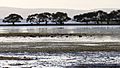
The bay itself has about 360 islands. Some of these are populated, like Russell, Macleay, Lamb, and Karragarra Islands, known as the Southern Moreton Bay Islands. Coochiemudlo Island and Bribie Island also have homes. In the past, Peel Island was used for growing sisal, as a quarantine station, and as a place for people with certain illnesses.
Moreton Bay is generally shallow and sandy. However, a deep channel is kept open for large international ships to reach the Port of Brisbane. Channels in the south of the bay are rarely deep. Most waves in the bay are created by local winds. The tide usually rises and falls between 1.5 and 2 meters. Moreton Bay has an average depth of 6.8 meters, but some parts are deeper than 30 meters. This shallow depth allows sunlight to reach the seafloor, helping marine plants grow and supporting many different animals. The bay covers 1,523 square kilometers, and the land area that drains into it is 14 times larger, at 21,220 square kilometers. The bay's waters are mostly blue. Western parts can sometimes look green from algae, brown from dirt, or yellow-brown from plant material. The average water temperature ranges from 21.0°C in July to 27.0°C in February.
Besides the Brisbane River, other rivers and creeks like the Pimpama River, Logan River, Albert River, Pine River, Tingalpa Creek, and the Schulz Canal all flow into Moreton Bay. Inside Moreton Bay are smaller bays such as Waterloo Bay, Redland Bay, Raby Bay, Deception Bay, and Bramble Bay.
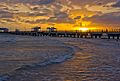
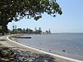
The bay has many island towns like Tangalooma on Moreton Island, and Dunwich and Amity Point on North Stradbroke Island. Important towns and suburbs on the mainland coast include Deception Bay, Scarborough, Redcliffe, Margate, Woody Point, Brighton, Sandgate, Cleveland, Victoria Point, and Redland Bay. Other popular spots include Pumicestone Passage and many boat ramps, marinas, and jetties, like the Shorncliffe pier.
Sandbanks
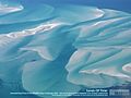
Moreton Bay is full of sandbanks. These sandbanks formed after the sea level reached its current position about 6,500 years ago. Between Tangalooma and Skirmish Point on Bribie Island are the Middle Banks, Central Banks, and Western Banks. North of Moreton Island, you can find the Yulle Road, Spitfire Bank, and Salamander Bank.
Amity Banks are just west of Amity Point, and Moreton Banks are west of the southern tip of Moreton Island. These sandbanks can be dangerous for boats because they are always changing due to the tides.
The Middle Banks area near Moreton Island has been used to get sand for big projects like the Brisbane Airport and port facilities. About 18 million cubic meters of sand have been removed, and another 40 million cubic meters are planned to be taken. This sand extraction is expected to help a project to straighten a major shipping channel.
To keep the shipping channel open, some areas of the bay are used for dumping dredged material. These sites are chosen to help beaches by adding sand back to them naturally.
Flora and Fauna
Moreton Bay's protected wetlands, mudflats, and waterways are very healthy. They support up to 25% of Australia's bird species at different times of the year. The mix of muddy areas on the west side and sandy areas on the east side, along with coral and seagrass beds, supports over 43 species of shorebirds. Seven types of seagrass grow in Moreton Bay, with Zostera capricorni being the most common. Sadly, some seagrass has been lost since European settlement due to more dirt and mud flowing into the bay.
About 50,000 wading birds visit Moreton Bay each year. Its wetlands are considered an Important Bird Area (IBA). The Queensland Government says that Moreton Bay's large tidal areas are vital for shorebirds to rest, feed, and sometimes breed.
The bay is also home to many other animals, including whales, dolphins, dugongs, sharks, and turtles. From 1824 to 1950, turtles were hunted for business. The loggerhead turtle population in the bay is the most important in Australia.
Moreton Bay is one of the top ten dugong habitats in Australia. It is considered one of the most important areas for dugongs in Queensland. Moreton Bay is the only place in Australia where dugongs gather in herds. In the past, these herds numbered in the thousands, with some herds being 5 kilometers long. In 2009, there were only between 600 and 800 dugongs left. Dugongs were traditionally eaten by Indigenous Australians. Early Europeans also hunted them for their oil and other products until the 1920s.
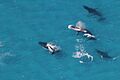
Many types of whales and dolphins can be found in Moreton Bay, including humpback whales, killer whales, southern right whales, and various dolphins. Under Australia's EPBC Act, the southern right whale is listed as endangered, and the humpback whale is listed as vulnerable. Companies offer whale watching trips from June to September each year. Most large whales seen in the bay are humpbacks, and several smaller dolphins live or visit the bay regularly.
The Moreton Bay bug (Thenus orientalis) is a type of slipper lobster found in the waters off Australia's north coast. This "bug" is a special and expensive food served in many restaurants in Queensland.
The Moreton Bay fig (Ficus macrophylla) is a large tree that grows naturally on the east coast of Australia, especially around Moreton Bay.
The southern and western parts of the bay have shallow, muddy waters that are protected from strong waves by the islands. This creates a great home for mangroves. Seven different species of mangroves grow well in the bay, especially in the sheltered southern areas. The Avicennia marina species is the most common.
About 1% of the bay is coral reef. Land clearing and settlement have made it harder for corals to grow. However, climate change is expected to raise sea levels and make the waters warmer, which might help coral growth in the bay.
The bay can sometimes have large outbreaks of a bacteria called lyngbya. This bacteria can cause skin rashes and asthma attacks if you touch it.
The eastern shovelnose ray is very common in Moreton Bay and plays an important role in the food chain of the area.
Ship Strikes to Marine Animals
One serious danger to marine animals in Moreton Bay is being hit by boats. Dugongs and turtles are often killed or hurt when fast boats hit them.
Southern right whales are critically endangered off Australia's east coast. While humpback whales have returned, southern right whales have been much slower to recover, partly due to illegal hunting in the past.
Recently, there have been more sightings of southern right whales along the east coast, showing a very slow but steady recovery. Moreton Bay was likely an important place for these whales to have their babies. Small groups of southern right whales have been seen visiting the southern bay each year since 2002, especially around Toondah Harbour.
However, in August 2014, a southern right whale calf was sadly killed when it was hit by a ferry. Its mother was also badly injured. Another southern right whale, possibly with a calf, was hit a few days before this incident. These boat strikes and getting tangled in fishing gear can seriously prevent these whales from returning to their old homes.
Environment
Environmental Threats
Moreton Bay's seagrass beds and corals are constantly threatened by soil washing off from farms in the Lockyer Valley and from construction in south east Queensland. Experts have noted that mud now flows into Moreton Bay 10 times faster than it did before Europeans settled here 120 years ago. A report from 2013 showed that the health of Moreton Bay's ecosystem got worse between 2012 and 2013. Water quality was also affected by big floods in 2009 and 2011.
After the 2011 Brisbane River floods washed polluted water into the bay, fishermen were warned not to catch or eat seafood from its waters. The flood plume (a cloud of polluted water) was studied to see how it affected the bay's marine life. It contained sewage, pesticides, heavy metals like lead and zinc, and other harmful chemicals.
An oil spill happened in March 2009 when the MV Pacific Adventurer ship dumped 100 tonnes of oil and other toxic chemicals onto Brisbane's beaches. The Premier of Queensland called it the "worst environmental disaster Queensland has ever seen."
On November 2, 2012, the Queensland Government announced plans to build an international cruise ship terminal and other developments for the Southport Broadwater at the southern end of Moreton Bay. This project is opposed by environmental groups.
On May 31, 2014, a plan was released for the Toondah Harbour area in Cleveland. This plan would allow a large marina with up to 400 boat berths to be built in southern Moreton Bay. This plan was opposed by marine experts and environmental groups. A petition with 1,211 signatures against the plan was given to the Queensland Parliament.
Fun Activities
The bay is very popular for recreational fishing. The Moreton Bay Classic fishing competition is held every year from the Manly foreshore. There is also a good fishing spot near the shipwreck of Mount Elliot.
Many sailing events take place on Moreton Bay, including:
- Yacht and dinghy races organized by the Royal Queensland Yacht Squadron at Manly.
- The Brisbane to Gladstone yacht race, which started in 1949, begins near the Shorncliff Pier every year on Good Friday.
- The Interclub Bay Cruise, held each year during the first week of the Queensland September school holidays.
The bay is also great for many other water sports and activities like kayaking, jet-skiing, windsurfing, and water-skiing. Diving and snorkeling are popular around Tangalooma on Moreton Island.
Images for kids
-
Matthew Flinders sailed between Moreton Island and Bribie Island in 1799.
-
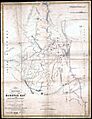
Map of Moreton Bay made in 1842 by Robert Dixon
-
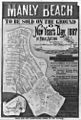
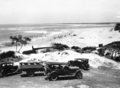
Land for sale in Manly in 1887
-
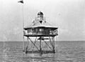
Moreton Bay Pile Light, c. 1912
-
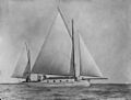
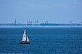
Sailing on Moreton Bay in 1915
-
Woody Point jetty at Woody Point
-
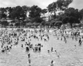
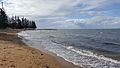
Beach scene, Sandgate December 1937
-
The first of the Tangalooma Wrecks were placed in 1963, one year after the whaling station ceased operations.
-
The Port of Brisbane from Bramble Bay
-
Scarborough Beach at Scarborough on the Redcliffe Peninsula
-
Bribie Island and entrance to Pumicestone Channel Caloundra 1930
-
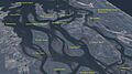
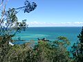
The islands of southern Moreton Bay
-
Sandbanks in Moreton Bay
-
Humpback whales in Moreton Bay
-
Lovers Walk and Shorncliffe pier at Shorncliffe
-
Suttons Beach at Redcliffe
-
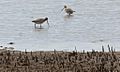
Godwits feeding on Cleveland foreshore in area proposed for marina development
-
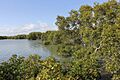
Mangroves, Toondah Harbour, Cleveland
-
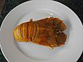
Cooked whole Moreton Bay bug (a type of slipper lobster)
-
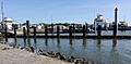
Toondah Harbour, Cleveland
-
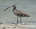
Eastern curlew
-
Cassim Island viewed from G.J. Walter Park, Cleveland
-
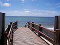
The foreshore at Manly, 2004

.jpg)


.jpg)


