
Caboolture River facts for kids
Quick facts for kids Caboolture |
|
|---|---|

Railway Bridge over the Caboolture River, 1907
|
|

Location of the Caboolture River mouth in Queensland
|
|
| Country | Australia |
| State | Queensland |
| Region | South East Queensland |
| Local government area | Moreton Bay Region |
| City | Caboolture |
| Physical characteristics | |
| Main source | D'Aguilar Range below Campbells Pocket 262 m (860 ft) 27°7′32″S 152°48′20″E / 27.12556°S 152.80556°E |
| River mouth | Deception Bay, Moreton Bay south of Beachmere 0 m (0 ft) 27°09′09″S 153°02′48″E / 27.15250°S 153.04667°E |
| Length | 46 km (29 mi) |
| Basin features | |
| Basin size | 468 km2 (181 sq mi) |
| Tributaries |
|
| National park | D'Aguilar National Park |
The Caboolture River is a small but important river in South East Queensland, Australia. It flows through a region known for its natural beauty and growing towns. This river is a key part of the local environment and history.
Contents
Where is the Caboolture River Located?
The Caboolture River starts in the D'Aguilar Range, a mountain range near Campbells Pocket. It then flows generally towards the east. Along its journey, it passes through several towns like Rocksberg, Caboolture, and Morayfield.
How Long and High is the River?
The river is about 46 kilometers (29 miles) long. It begins at an elevation of 262 meters (860 feet). The river ends its journey by flowing into Deception Bay. This bay is part of the larger Moreton Bay, located south of Beachmere.
What is a Catchment Area?
The river's catchment area covers 468 square kilometers (181 square miles). A catchment area is all the land where water collects and flows into a specific river. Think of it like a giant funnel that directs all the rainwater into the Caboolture River.
River Features and Flow
The Caboolture River has a weir, which is like a small dam that controls water flow. The river is affected by tides for about 19 kilometers (12 miles) upstream from its mouth. This means the water level goes up and down with the ocean tides. At the river's mouth, a sand bar helps to reduce the strong impact of the ocean tides.
Protecting the Caboolture River Environment
The area around the Caboolture River is seeing more urban development. This means more houses and buildings are being built. This growth can sometimes threaten the river's health.
What are the Environmental Challenges?
One big challenge is land clearing. When forests are cut down, it can harm the environment. This leads to more stormwater and sewage runoff flowing into the river. This runoff can carry too many nutrients and sediment, which are not good for the river's ecosystem.
Most of the plants along the riverbanks have been cleared. However, there are still important mangrove forests near the river's mouth. These mangroves are vital for the river's health and provide homes for many animals.
Efforts to Help the River
Good news! An upgrade at the Caboolture Sewerage Treatment plant has helped reduce some of the pollution. Also, the upper parts of the river's catchment area are protected. They are part of the D'Aguilar National Park. This park helps keep the natural environment safe.
Understanding Flooding Risks
The Caboolture River, along with the nearby Pine River, can experience sudden floods. These "flash floods" happen quickly and can cause a lot of damage. Major floods have been recorded in many years, including 1967, 1974, 1989, 2010, and 2015.
History of the Caboolture River
The land around the Caboolture River has a rich history. It has been home to people for a very long time.
Traditional Owners of the Land
The Kabi Indigenous people are the traditional custodians of the Caboolture River area. This means they have lived on and cared for this land for thousands of years. The name Kabultur comes from their language. It means "place of the carpet snake."
The Kabi people lived off the land. They gathered bush food, fresh water mussels, and oysters. They also fished and hunted game animals. They moved around the land to find the best food available during different seasons.
Early European Exploration
In 1823, an explorer named John Oxley explored the waterway. He first called it the Deception River. He gave it this name because of the many sandbars at its mouth, which made it tricky to navigate.
Later, the Caboolture River was used to transport timber. Large rafts of red cedar timber were floated down the river. This timber came from Mount Mee and was taken to Deception Bay.
Images for kids
-
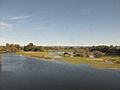
View from train crossing, 2014

