Morayfield, Queensland facts for kids
Quick facts for kids MorayfieldMoreton Bay, Queensland |
|||||||||||||||
|---|---|---|---|---|---|---|---|---|---|---|---|---|---|---|---|

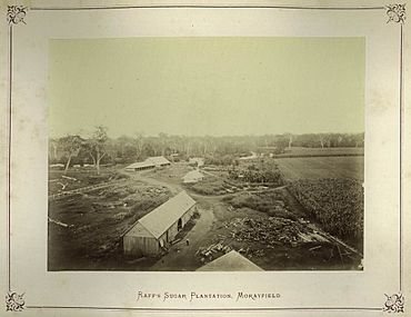
Raff's Sugar Plantation, 1874
|
|||||||||||||||
| Population | 24,898 (2021 census) | ||||||||||||||
| • Density | 559.5/km2 (1,449/sq mi) | ||||||||||||||
| Postcode(s) | 4506 | ||||||||||||||
| Area | 44.5 km2 (17.2 sq mi) | ||||||||||||||
| Time zone | AEST (UTC+10:00) | ||||||||||||||
| Location |
|
||||||||||||||
| LGA(s) | City of Moreton Bay | ||||||||||||||
| State electorate(s) |
|
||||||||||||||
| Federal Division(s) | Longman | ||||||||||||||
|
|||||||||||||||
Morayfield is a town and suburb in the City of Moreton Bay, Queensland, Australia. It is located about 45.8 kilometers (28.5 miles) north of Brisbane CBD, which is the capital city of Queensland.
In the 2021 census, Morayfield had a population of 24,898 people. It's a growing area with a mix of homes and shops.
Contents
Exploring Morayfield's Location
Morayfield is mostly a place where people live. You'll find many brick homes and some larger properties with more land. The main shopping area is along Morayfield Road. This road is home to the Morayfield Shopping Centre.
The suburb is also part of the Burpengary Creek area. The Bruce Highway and the Caboolture railway line both pass through Morayfield, running from south to north.
A Look Back: Morayfield's History
Morayfield has an interesting past. In 1868, a man named George Raff bought land here. He named it "Moray Field" after his home area in Morayshire, Scotland. Over time, the name changed from "Morayfields" to "Morayfield" by 1881.
Early Schools in Morayfield
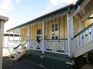
The first school in the area, Caboolture State School, opened on August 4, 1873. It was later renamed Caboolture South State School in 1890. In 1908, it became Morayfield State School. The original school building is still standing and is considered a historic site.
Morayfield State High School opened its doors on January 27, 1981. By 2023, it had more than 1,600 students!
Other schools also opened as the area grew:
- Morayfield East State School opened on January 29, 1991.
- Minimbah State School opened on January 28, 1997.
Growth and Development
Until the mid-1980s, Morayfield was mostly a rural area. It had small dairy farms and places that grew crops. But as the population of the greater Brisbane area grew, Morayfield started to develop quickly. Many new homes were built, and the population increased a lot.
The Morayfield Shopping Centre opened on April 14, 1997. It was expanded in 2005, making it even bigger.
In January 2011, some parts of Morayfield experienced flooding during the 2010-2011 Queensland floods.
Carmichael College, a private school, started as a primary school in 2015. It began offering secondary schooling in 2020 and plans to teach students up to Year 12 by 2025.
Who Lives in Morayfield?
In 2021, Morayfield had a population of 24,898 people. The median age of people living in Morayfield in 2016 was 32 years old. This was younger than the national average age of 38.
Most people (77.2%) living in Morayfield in 2016 were born in Australia. Other countries of birth included New Zealand (5.5%) and England (3.3%). Most people (88.2%) spoke only English at home.
Historic Places in Morayfield
Morayfield has several places that are listed as heritage sites. This means they are important historical locations. These include:
- 68 Captain Whish Avenue: Oaklands Sugar Mill
- 196–230 Morayfield Road: Morayfield State School
- 34 Nolan Drive: Morayfield Plantation
Education Opportunities
Morayfield has several schools for students of all ages.
- Morayfield State School is a government primary school for students from Prep to Year 6. It is located at 196–230 Morayfield Road. The school also has a special education program.
- Minimbah State School is another government primary school for Prep to Year 6 students. You can find it at the corner of Walkers Road and Minimbah Drive. It also offers a special education program.
- Morayfield East State School is a government primary school for Prep to Year 6. It is located at 107 Graham Road. In 2023, it had 973 students and a special education program.
- Morayfield State High School is a government secondary school for students in Years 7 to 12. It is on Visentin Road. In 2023, 1,687 students attended this school, which also has a special education program.
- Carmichael College is a private school that teaches students from Prep all the way to Year 12. It is located at 793-833 Oakey Flat Road. The school is named after a missionary named Amy Carmichael. A church, Creekside Community Church, is on the school campus and supports the school.
Getting Around Morayfield
Morayfield has different ways to get around, including trains and buses.
Train Travel
The Morayfield railway station offers regular train services. You can travel to Brisbane and Ipswich, as well as to nearby Caboolture and the Sunshine Coast.
Bus Services
Most bus services in Morayfield either go through or start/end at the Morayfield Bus Station. This station is located at 171 Morayfield Road, next to Devereaux Drive, and is close to the Morayfield Shopping Centre.
Buses also connect to the Morayfield railway station. However, some bus routes, like the 660, travel along Morayfield Road and bypass the train station. The 9999 route ends at the Morayfield Bus Station.
Some bus journeys can take a long time, especially if you need to connect between different routes. For example, a trip that takes less than 15 minutes by car might take over 1.5 hours by bus. There are also fewer bus services in the mornings and afternoons, as many buses are used for school runs during those times.
Here are some of the local bus services:
- The 667 local loop bus service helps people travel within the southern part of Morayfield. It connects to other bus services at Morayfield Bus Station and train services at Morayfield railway station. On Sundays, this service also goes to Burpengary.
- The 656 service travels in a loop to Upper Caboolture. It connects to train services at Morayfield railway station and bus services at Morayfield Bus Station.
- Bus routes 653 and 654 connect Morayfield to Caboolture South and Bellmere. These routes also link to train services at both Morayfield and Caboolture railway stations.
- Bus route 651 travels from Morayfield railway station along Morayfield Road to northern Caboolture and back. This provides a bus connection to both Morayfield and Caboolture railway stations.
- The 660 bus also goes to Morayfield Bus Station, connecting to places like Redcliffe, Caboolture, Burpengary, and Deception Bay.
- Bus 9999 operates from Donnybrook and Toorbul on Thursday mornings and afternoons. It connects to Caboolture and Morayfield Bus Station.
- There is also a bus service from Kilcoy through the QConnect network, route number 895. This service stops in Woodford, D'Agulair, Wamuran, Caboolture, and ends at Morayfield Bus Station.
See also
- List of tramways in Queensland
 | Emma Amos |
 | Edward Mitchell Bannister |
 | Larry D. Alexander |
 | Ernie Barnes |


