Caboolture South, Queensland facts for kids
Quick facts for kids Caboolture SouthMoreton Bay, Queensland |
|||||||||||||||
|---|---|---|---|---|---|---|---|---|---|---|---|---|---|---|---|

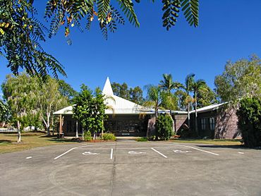
Caboolture Baptist Church, 2007
|
|||||||||||||||
| Population | 7,539 (2021 census) | ||||||||||||||
| • Density | 1,713/km2 (4,440/sq mi) | ||||||||||||||
| Postcode(s) | 4510 | ||||||||||||||
| Area | 4.4 km2 (1.7 sq mi) | ||||||||||||||
| Time zone | AEST (UTC+10:00) | ||||||||||||||
| Location |
|
||||||||||||||
| LGA(s) | City of Moreton Bay | ||||||||||||||
| State electorate(s) | Morayfield | ||||||||||||||
| Federal Division(s) | Longman | ||||||||||||||
|
|||||||||||||||
Caboolture South is a suburb located in the City of Moreton Bay in Queensland, Australia. It's a place where over 7,500 people live, according to the 2021 census.
Contents
Exploring Caboolture South's Location
This suburb is surrounded by natural features. The Caboolture River forms its northern and western borders. Cundoor Creek, a smaller waterway, is to the east.
How the Railway Divides the Suburb
The North Coast railway line runs through Caboolture South. It enters from the south-east and leaves towards the north-east. This railway line actually splits the suburb into two main parts.
West of the railway line, you'll find homes and local services. East of the line, the land is used for businesses and farms. A main road, the Burpengary–Caboolture Road (also called Morayfield Road), also passes through the suburb from south to north.
A Glimpse into Caboolture South's Past
The name Caboolture comes from the Yugarabul Aboriginal language. It means "place of carpet snake". This name refers to an area south of the original Caboolture township.
Early Schools in the Area
Caboolture State School first opened its doors on 4 August 1873. In 1890, its name changed to Caboolture South State School. Later, in 1908, it was renamed Morayfield State School. Caboolture Special School began teaching students in January 1980.
Who Lives in Caboolture South?
Let's look at the people who call Caboolture South home.
Population Growth Over Time
In 2011, Caboolture South had 4,857 residents. By 2016, the population grew to 5,300 people. The most recent census in 2021 showed a population of 7,539 people.
Diversity in the Community
In 2011, the average age of people in Caboolture South was 31 years old. This was younger than the national average of 37. About 5.6% of the population identified as Aboriginal and Torres Strait Islander people.
Most residents (77.7%) were born in Australia. Other countries of birth included New Zealand (4.9%), England (3.6%), and the Philippines (0.8%). English was the main language spoken at home by 89.1% of people. Other languages included Samoan, German, and Cantonese.
Learning and Education in Caboolture South
Education is important in Caboolture South.
Caboolture Special School
Caboolture Special School is a school for students with special needs. It teaches boys and girls from Prep (the first year of primary school) all the way to Year 12. The school is located on Torrens Road. In 2018, it had 250 students and a large team of teachers and staff.
Nearby Mainstream Schools
There are no regular primary or secondary schools directly within Caboolture South. However, students can attend nearby schools. These include Caboolture State School and Caboolture State High School in Caboolture. Also, Morayfield State School and Morayfield State High School are in Morayfield. Minimbah State School is another option in Morayfield.
Places to Visit and Things to Do
Caboolture South has several places for shopping, worship, and recreation.
Shopping and Community Places
Market Plaza shopping centre is a popular spot. It has a Woolworths supermarket and other specialty shops. You can find it on Morayfield Road. The Caboolture Baptist Church is located on Grant Road.
Parks and Green Spaces
For outdoor activities, there's the Caboolture Arboretum. It's in the north-west of the suburb, right next to the Caboolture River. This arboretum offers green spaces, walking paths, and even duck ponds. Leemon Park is another green area, found on Penhurst Street.
 | James Van Der Zee |
 | Alma Thomas |
 | Ellis Wilson |
 | Margaret Taylor-Burroughs |


