Upper Caboolture, Queensland facts for kids
Quick facts for kids Upper CabooltureQueensland |
|||||||||||||||
|---|---|---|---|---|---|---|---|---|---|---|---|---|---|---|---|

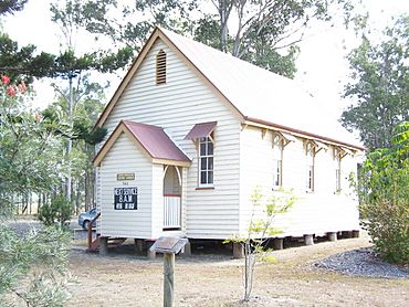
Upper Caboolture Uniting Church, 2006
|
|||||||||||||||
| Population | 5,087 (2021 census) | ||||||||||||||
| • Density | 417.0/km2 (1,080/sq mi) | ||||||||||||||
| Postcode(s) | 4510 | ||||||||||||||
| Area | 12.2 km2 (4.7 sq mi) | ||||||||||||||
| Time zone | AEST (UTC+10:00) | ||||||||||||||
| Location |
|
||||||||||||||
| LGA(s) | City of Moreton Bay | ||||||||||||||
| State electorate(s) |
|
||||||||||||||
| Federal Division(s) | Longman | ||||||||||||||
|
|||||||||||||||
Upper Caboolture is a place in Queensland, Australia. It's part of the City of Moreton Bay. It used to be a country area near the town of Caboolture. But since the 1990s, it has grown with more houses and people.
In 2021, about 5,087 people lived in Upper Caboolture.
In April 2023, the Queensland Government changed the map a bit. They created five new areas called Corymbia, Greenstone, Lilywood, Wagtail Grove, and Waraba. These new areas were made from parts of Upper Caboolture and other nearby places like Bellmere and Rocksberg. Upper Caboolture gave some of its land to the new areas of Lilywood and Wagtail Grove.
Geography of Upper Caboolture
The Caboolture River forms part of the northern edge of Upper Caboolture.
A new road called the Bruce Highway Western Alternative is planned to go through Upper Caboolture. It will run from the south to the north of the area.
History of Upper Caboolture
The first school in the area was Camp Flat Provisional School. It opened on January 28, 1878, with 22 girls and 29 boys. This school was on Caboolture River Road. On January 19, 1880, it became Camp Flat State School. Later, in 1916, its name changed to Caboolture Upper State School. The school closed in 1918.
As mentioned, Upper Caboolture was once a quiet rural spot. However, since the 1990s, it has seen more and more homes being built. This means it has become more like a town and less like the countryside.
In April 2023, the Queensland Government decided to create new areas to help manage the growing population. These new areas, including Lilywood and Wagtail Grove, were formed by taking parts of Upper Caboolture and other nearby places.
Population and People
Let's look at how the population of Upper Caboolture has changed over the years:
- In 2011, there were 3,752 people living here.
- About 51.7% were female and 48.3% were male.
- The average age was 34 years old.
- Most people (80.1%) were born in Australia.
- Other countries of birth included England (4.3%) and New Zealand (4.1%).
- Most people (92.3%) spoke only English at home.
- By 2016, the population had grown to 4,214 people.
- In 2021, the population reached 5,087 people. This shows that Upper Caboolture is a growing community!
 | May Edward Chinn |
 | Rebecca Cole |
 | Alexa Canady |
 | Dorothy Lavinia Brown |


