
Rocksberg facts for kids
Quick facts for kids RocksbergQueensland |
|||||||||||||||
|---|---|---|---|---|---|---|---|---|---|---|---|---|---|---|---|

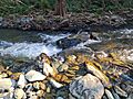
Mid-morning at the creek in Rocksberg Heritage Park, Queensland, Australia.
|
|||||||||||||||

Rocksberg
Location in Queensland
|
|||||||||||||||
| Population | 277 (2021 census) | ||||||||||||||
| • Density | 10.95/km2 (28.4/sq mi) | ||||||||||||||
| Postcode(s) | 4510 | ||||||||||||||
| Area | 25.3 km2 (9.8 sq mi) | ||||||||||||||
| Time zone | AEST (UTC+10:00) | ||||||||||||||
| Location |
|
||||||||||||||
| LGA(s) | City of Moreton Bay | ||||||||||||||
| State electorate(s) | Glass House | ||||||||||||||
| Federal Division(s) | Longman | ||||||||||||||
|
|||||||||||||||
Rocksberg is a quiet country area located in the City of Moreton Bay, Queensland, Australia. It's a place where you can find open spaces and a peaceful lifestyle. In 2021 census, about 277 people lived in Rocksberg.
Contents
What is Rocksberg Like?
Rocksberg is a rural locality, which means it's mostly countryside with homes spread out. The Caboolture River flows through Rocksberg from north to east. This river is important for the area's farms.
There's a spot called Zillmans Crossing (27°07′18″S 152°51′32″E / 27.1218°S 152.8588°E) on the river. It used to be a shallow place where people could cross the river, but now it's a low bridge. This crossing was named after Leopold Zillman, who was one of the first farmers here.
The land near the river is flat and used for farming, mainly for grazing animals. However, the western part of Rocksberg has undeveloped mountains. The highest point in these mountains is about 350 metres above sea level. You can also find a nice picnic area near Zillmans Crossing.
Rocksberg's Past
The name Rocksberg comes from the Zillman family's property. They were early settlers in the area.
In the early 1840s, some explorers and farmers created the first road north from Brisbane. This road, now called Old North Road, helped connect farms like Durundur and Kilcoy to Brisbane. Later, new roads were built closer to the coast, like the Bruce Highway, which is used today.
Rocksberg used to have its own school! Rocksberg Provisional School opened on 19 June 1893. It became Rocksberg State School in 1909 but closed its doors in 1954. The old school was located around 5 W James Road (27°06′23″S 152°50′10″E / 27.1063°S 152.8361°E).
In April 2023, the Queensland Government made some changes to the local map. They created five new areas nearby: Corymbia, Greenstone, Lilywood, Wagtail Grove, and Waraba. These new areas were formed by taking parts of existing places like Rocksberg. So, Rocksberg became a little smaller, with some of its land now part of Corymbia, Greenstone, and Wagtail Grove.
Who Lives in Rocksberg?
In 2011 census, there were 302 people living in Rocksberg. The average age was 43 years old. Most people (76.6%) were born in Australia. Other countries of birth included England, New Zealand, South Africa, Indonesia, and the Netherlands. Most people spoke only English at home.
By 2016 census, the population was 300 people. In the most recent 2021 census, the population was 277 people.
Learning and Fun in Rocksberg
Rocksberg doesn't have its own schools right now. Kids living here usually go to primary schools in nearby areas like Bellmere, Morayfield, or Dayboro. For high school, students might attend Tullawong State High School in Caboolture, Morayfield State High School in Morayfield, or Bray Park State High School in Bray Park.
For fun and learning about the past, you can visit Rocksberg Park Heritage Reserve. It's a recreational area on McNamara Road, right next to the Caboolture River (27°05′40″S 152°50′14″E / 27.0944°S 152.8371°E). This park has information about the early settlers of the area and is part of the Caboolture Heritage Drive.
Images for kids
-
Mid-morning at the creek in Rocksberg Heritage Park, Queensland, Australia.
