Narangba, Queensland facts for kids
Quick facts for kids NarangbaBrisbane, Queensland |
|||||||||||||||
|---|---|---|---|---|---|---|---|---|---|---|---|---|---|---|---|

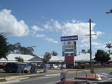
Narangba Village Shopping Centre
|
|||||||||||||||
| Population | 20,910 (2021 census) | ||||||||||||||
| • Density | 482.9/km2 (1,251/sq mi) | ||||||||||||||
| Postcode(s) | 4504 | ||||||||||||||
| Area | 43.3 km2 (16.7 sq mi) | ||||||||||||||
| Time zone | AEST (UTC+10:00) | ||||||||||||||
| Location |
|
||||||||||||||
| LGA(s) | City of Moreton Bay | ||||||||||||||
| State electorate(s) |
|
||||||||||||||
| Federal Division(s) | |||||||||||||||
|
|||||||||||||||
Narangba is a town and suburb in the City of Moreton Bay, Queensland, Australia. It is located about 34 kilometers (21 miles) north of Brisbane's city center. Narangba started as a rural area but is now growing into a residential suburb. It is becoming part of the larger Brisbane metropolitan area. In 2021, Narangba had a population of 20,910 people.
Contents
Narangba's Location
Narangba is easy to reach! The Bruce Highway, a big road, goes through the suburb. This highway connects Narangba to places like Dakabin and North Lakes to the south-east. It also links to Burpengary and Deception Bay to the north-east.
The North Coast railway line also runs through Narangba. This train line connects the suburb to Kurwongbah and Dakabin in the south, and Burpengary in the north. You can find the Narangba railway station right in the suburb.
A Look at Narangba's History
Narangba is located in the traditional country of the Yugarabul Indigenous Australian people. The name Narangba might come from an Aboriginal word meaning "small place" or "small ridge." Before it was called Narangba, this area was known as Stoney Creek. The railway station was first named Sideling Creek Station, but it was later changed to Narangba. The suburb is also part of the Burpengary Creek area.
Schools Opening in Narangba
Over the years, several schools have opened in Narangba:
- Narangba State School opened on 27 January 1910.
- Jinibara State School opened on 29 January 1996.
- Narangba Valley State High School opened on 1 January 2000.
- Narangba Valley State School opened on 1 January 2005.
Who Lives in Narangba?
In 2021, Narangba had a population of 20,910 people. The suburb has grown quite a lot over the years! For example, in 1911, only 58 people lived there. By 1991, the population was 992, and by 2006, it had jumped to 12,997. This shows how much Narangba has developed.
In 2016, the median age of people in Narangba was 32 years old. This was younger than the national average of 38. Most people (78.2%) living in Narangba were born in Australia. Other countries where people were born included England (5.7%), New Zealand (5.1%), and South Africa (1.1%). Most people (91.7%) spoke only English at home.
Education in Narangba
Narangba has several schools for students of different ages.
- Narangba State School is a government primary school for students from Prep to Year 6. It is located on School Street. In 2018, it had 712 students and also offered a special education program.
- Jinibara State School is another government primary school for Prep to Year 6 students. You can find it on 50 Cottontree Drive. In 2018, this school had 784 students and also provided a special education program.
- Narangba Valley State School is a government primary school for Prep to Year 6. It is located on Creekside Drive. In 2018, it was a larger school with 1,157 students and a special education program.
- Narangba Valley State High School is a government secondary school for students from Year 7 to Year 12. It is on Harris Avenue. In 2018, it had 2,027 students and also offered a special education program.
A new Catholic primary and secondary school is planned to open in 2025. It will start with Prep to Year 3 and Year 7 classes.
Things to Do in Narangba
Narangba has many places for sports and recreation!
Sports and Activities
There are great sporting facilities in Narangba. You can find two baseball/softball pitches and three soccer fields off Harris Avenue. This is where the Narangba Eagles FC soccer team plays. There are also two rugby fields at Duncombe Park. If you like basketball, there's a half-court. For dog owners, there's a dog park, and for skateboarders, a small skate park is available off Harris Avenue.
Parks to Explore
Narangba has several parks where you can relax and play:
- Gekko Gully Park
- Narangba Sporting Complex
- Narangba Sports Reserve
Getting Around Narangba
Transport in Narangba is convenient, making it easy to travel locally and to other cities.
Train Services
The Narangba railway station offers regular Queensland Rail City network train services. You can catch a train to Brisbane and Ipswich, as well as to Caboolture and the Sunshine Coast. In 2014, the train station was updated with new platforms and secure car parks. It now serves as a key stop for express trains.
Bus Services
Local bus services help people get around Narangba. The 663 bus route is a local loop that connects different parts of the suburb to the train station. The 668 service runs from Narangba railway station to the nearby suburb of North Lakes.
Road Access
Because Narangba is close to the Bruce Highway, it's easy to drive to both the Sunshine Coast and Brisbane.
 | Sharif Bey |
 | Hale Woodruff |
 | Richmond Barthé |
 | Purvis Young |


