Toorbul, Queensland facts for kids
Quick facts for kids ToorbulQueensland |
|||||||||||||||
|---|---|---|---|---|---|---|---|---|---|---|---|---|---|---|---|

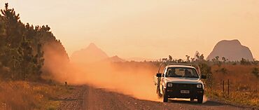
Toorbul with Glasshouse Mountains beyond, 2022
|
|||||||||||||||
| Population | 958 (2021 census) | ||||||||||||||
| • Density | 37.13/km2 (96.2/sq mi) | ||||||||||||||
| Postcode(s) | 4510 | ||||||||||||||
| Area | 25.8 km2 (10.0 sq mi) | ||||||||||||||
| Time zone | AEST (UTC+10:00) | ||||||||||||||
| Location |
|
||||||||||||||
| LGA(s) | City of Moreton Bay | ||||||||||||||
| State electorate(s) | Pumicestone | ||||||||||||||
| Federal Division(s) | Longman | ||||||||||||||
|
|||||||||||||||
Toorbul is a small coastal town in Queensland, Australia. It is part of the City of Moreton Bay. In 2021, about 958 people lived in Toorbul.
Contents
Where is Toorbul?
Toorbul is located about 49 kilometers (30 miles) north of Brisbane. To its east, you'll find the Pumicestone Channel. This water separates the mainland from Bribie Island.
Elimbah Creek is to the north, and Ningi Creek is to the south. Both creeks flow into the Pumicestone Channel. There are also small, flat islands nearby, like Parrot Island and Shag Island.
The main part of the town is on the northeast coast. Pumicestone Road is the main road that runs through Toorbul. It connects the town from the west (near Caboolture) to the coast.
A Look Back in Time
How Toorbul Got Its Name
The town's name comes from Toorbul Point. It is believed to be a word from the Yuggera language (Yugarabul dialect). This word refers to a specific Aboriginal group linked to the Ninghi area. Interestingly, Toorbul Point is not actually inside the Toorbul area today. It is in Sandstone Point, which is to the southeast.
Early Schools
Toorbul Provisional School first opened around 1891. It later became Toorbul State School in 1909. The school closed down for a while sometimes, probably because not enough students were attending. It closed for good around 1935. The old school was located at 1461-1477 Pumicestone Road.
Toorbul During World War II
During World War II in 1944, a special radar station was built in Toorbul. It was called RAAF 210 Radar Station. This station used British-designed radar technology. It was one of only four such stations built in Queensland during the war.
Who Lives in Toorbul?
In 2011, Toorbul had 877 people living there. Most people (80%) were born in Australia. Other countries of birth included England and New Zealand. The average age of people in Toorbul was 53 years old. This was older than the national average of 37 years. Most people (88.2%) spoke only English at home.
By 2016, the population of Toorbul grew slightly to 930 people. In the most recent count in 2021, the population was 958 people.
Getting Around Toorbul
Toorbul does not have a regular public bus service every day. However, there is one bus service that runs every Thursday. This bus, route 9999, travels from Toorbul through Donnybrook. It connects people to other bus services in Caboolture and Morayfield.
Community Services
The Moreton Bay Regional Council offers a mobile library service. This library on wheels visits the Jetty Car Park on The Esplanade. It's a great way for people in Toorbul to borrow books and other materials.
Education in Toorbul
There are no schools located directly in Toorbul. Students living in Toorbul usually go to primary and secondary schools in nearby Caboolture.
Images for kids
 | Jackie Robinson |
 | Jack Johnson |
 | Althea Gibson |
 | Arthur Ashe |
 | Muhammad Ali |


