John Oxley facts for kids
Quick facts for kids
John Joseph William Molesworth Oxley
|
|
|---|---|

John Oxley, 1810
|
|
| Born | 1784 Kirkham Abbey, Yorkshire, England
|
| Died | 1828 (aged 43–44) |
| Occupation | British Explorer |
| Years active | 1799−1824 |
John Joseph William Molesworth Oxley (1784 – 25 May 1828) was an important explorer and surveyor in Australia. He worked during the early years of British settlement.
He became the Surveyor General of New South Wales. He is famous for his two trips into the middle of New South Wales. He also explored the Tweed River and the Brisbane River. These rivers are now in the state of Queensland.
Contents
Early Life
John Oxley was born in 1784 at Kirkham Abbey. This place is near Westow in Yorkshire, Great Britain. He was baptised on 6 July 1784. His parents were John and Arabella Oxley.
In 1799, when he was 15, John Oxley joined the Royal Navy. He started as a midshipman on the Venerable (1784). In October 1802, he sailed to Australia. He was a master's mate on the naval ship Buffalo. This ship helped map the coast, including Western Port. He stayed in the colonies for five years.
In 1805, Oxley became an acting lieutenant on the Buffalo. The next year, he went to Van Diemen's Land (now Tasmania). He was in charge of the ship Estramina.
He went back to England in 1807. From there, he was made first lieutenant of HMS Porpoise. This was a British warship stationed in NSW. He sailed back to NSW in November 1808. In 1809, the Porpoise visited Van Diemen's Land. Governor William Bligh was a passenger. Bligh had been removed from his position as governor. Oxley returned to England in 1810. He left the Navy in 1811.
Becoming Surveyor General
In 1812, Oxley sailed to Sydney as the Surveyor-General. This meant he was in charge of mapping and planning land. Lachlan Macquarie was the Governor at this time. Governor Macquarie really encouraged exploration. He had already sent George Evans to explore beyond the Blue Mountains. He also had a road built over the Blue Mountains.
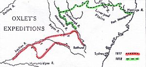
Macquarie wanted the Lachlan River and Macquarie River explored fully. These rivers flowed west, into the middle of the country. People wondered where they went. In 1817 and 1818, Governor Macquarie asked John Oxley to lead two trips to explore these rivers.
On his 1817 trip, Oxley found very marshy land. He thought this area was too wet to live in. He believed the Lachlan River flowed into huge swamps. He thought these swamps might be the edge of a large inland sea.
His 1818 trip to the Macquarie River also stopped at the Macquarie Marshes. The river was flooded, making the wetlands very full. Oxley tried hard to get through but could not. He became convinced that these westward-flowing rivers ended in an inland sea. He thought he had reached its swampy edge. This idea of an Australian inland sea became popular because of Oxley's reports.
Exploring the Lachlan River, 1817
In March 1817, John Oxley was told to explore the Lachlan River. He left Sydney on 6 April 1817. George Evans was his second-in-command. Allan Cunningham joined as a botanist, studying plants.
Oxley's group reached Bathurst after a week. They then started following the Lachlan River. They carried some supplies in boats. As they went west, the land around the river became more and more flooded. On 12 May, they found their way blocked by a huge marsh. They had to turn back.
They then tried going southwest, through dry, scrubby country. They ran out of water and lost two horses. This forced Oxley to return to the Lachlan River.
On 7 July, Oxley was near Booligal. He wrote that he was very sad to conclude that "the interior of this vast country is a marsh and uninhabitable." He decided to turn back. After resting, they started tracing their steps back along the Lachlan River.
They left the Lachlan River and crossed to the Bogan River. Then they went to the Wellington Valley, on the upper part of the Macquarie River. They followed this river back to Bathurst. They arrived on 29 August 1817.
Exploring the Macquarie River, 1818
Even though his Lachlan trip was disappointing, John Oxley agreed to explore the Macquarie River next. He left Bathurst on 28 May 1818. His group included George Evans, Dr. John Harris, and Charles Frazer. Twelve convict men also joined them. Governor Macquarie later wrote down their names. Five of these men had also been with Oxley on the Lachlan trip.
They took boats and nearly two dozen horses. The group reached the Macquarie Marshes. They then turned northeast towards the Warrumbungle mountains. They crossed the Castlereagh River. They saw the rich Liverpool Plains and found the Peel River and the Hastings River. Finally, they reached the NSW coast at what is now Port Macquarie. These discoveries were a big help to the NSW colony.
On 12 June 1818, Oxley was near where Dubbo is today. He wrote that he had passed "over a very beautiful country." On 27 June, they saw a small hill and named it Mount Harris. They also saw mountains in the distance, which they named Arbuthnot's Ranges.
They continued by boat and horse until they reached the Macquarie Marshes. The river spread out into the reeds, and Oxley could not find its path any further. He wrote that he believed they were "in the immediate vicinity of an inland sea, or lake."
From there, he went back to Mount Harris. He sent George Evans ahead to find a path to the northeast. When Evans returned, the group crossed the river that Oxley named the Castlereagh. They went towards the Warrumbungle Mountains and through the Gooriananwa Gap. From there, they found the rich soil of the Liverpool Plains.
On 26 August 1818, they climbed a hill. They saw rich, fertile land (Peel River) below them. This was near the future site of Tamworth. They continued east and crossed the Great Dividing Range. On 13 September 1818, they passed the Apsley Falls. Oxley named them the Bathurst Falls. He called them "one of the most magnificent waterfalls we have seen."
When they reached the Hastings River, they followed it to where it met the sea. Oxley named this spot Port Macquarie.
Governor Macquarie was very happy with the twelve convict men who went on this trip. He promised to give them "Conditional Pardons" as a reward for their good behavior.
Exploring Shoalhaven and Jervis Bay, 1819
In late 1819, Oxley and Assistant Surveyor-General James Meehan led two separate trips at the same time. Oxley went down the coast by sea to the Shoalhaven. Meehan went by land, starting from the Minnamurra River. They met at the Shoalhaven. Oxley reported that the soils in the Shoalhaven area were good. This made people more interested in farming there.
However, Oxley's report about the western shore of Jervis Bay was not good. He said, "We saw no place on which even a Cabbage might be planted with a prospect of success." He also said that "perhaps a more miserable sterile Country was never traversed by man."
Oxley's 1823 Expedition to Brisbane River
In 1823, Governor Brisbane sent Oxley north by boat. He was looking for a place to build a new prison settlement for difficult convicts. On this trip, he visited the Tweed River and its valley. He was very impressed. He wrote: "A deep rich valley clothed with magnificent trees... The view was altogether beautiful beyond description. The scenery here exceeded anything I have previously seen in Australia."
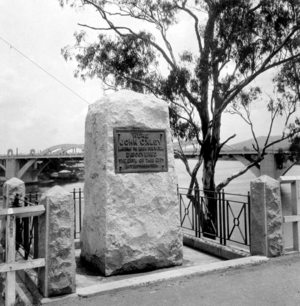
Oxley then sailed north on the Mermaid. Near Moreton Island, he found two escaped convicts. They had been living with the Aboriginal people. With their help, he was shown the Brisbane River, which he then named. He suggested this place for the new convict settlement. This settlement became Moreton Bay, and later the city of Brisbane. A monument was built at North Quay in 1924. It marks where he landed in Brisbane. He then explored further north to Port Curtis (where Gladstone is now). He continued exploring the area now known as South East Queensland.
In 1824, Oxley returned to the Brisbane River with Allan Cunningham. They traveled further up the river and found the Bremer River.
Personal Life
Governor Lachlan Macquarie gave Oxley 600 acres (about 240 hectares) of land near Camden in 1810. He increased this to 1,000 acres (about 400 hectares) in 1815. Oxley named this property Kirkham. He raised sheep there. He was also a director of the Bank of New South Wales for a short time.
Oxley had children before he married Emma Norton. In October 1821, Oxley married Emma Norton (1798–1885). She was the youngest sister of the lawyer James Norton.
Oxley and Emma Norton had a daughter and two sons. Their elder son, John Norton Oxley, became a Member of the Legislative Assembly. This was a political role in the government. Their younger son, Henry Oxley, also became a Member of the Legislative Assembly.
John Oxley was often sick during his time as an explorer. The difficult trips caused his health problems. He died on 25 May 1828 at his Kirkham property, near Camden. He was 44 years old.
Legacy
Many places and things are named after John Oxley to remember his important work:
- A statue of Oxley (around 1891) is in Sydney.
- A statue was put up in Brisbane in 1924 to celebrate 100 years since he discovered the Brisbane River.
- The John Oxley Memorial was built in Redcliffe, Queensland in 1932.
- In 1976, Australia Post put his picture on a postage stamp.
- In 2012, a metal shape of Oxley was put up in Kirkham.
- Oxley's Memorial, an anchor from a survey ship, is near Tamworth. It marks the route Oxley took in 1818.
- The John Oxley Landing Memorial was put up in Newstead House Park, Newstead, Queensland in 1983.
Places and other items named after him include:
- Electoral districts (areas for voting) in New South Wales and Queensland, like the Division of Oxley.
- Suburbs like Oxley (ACT) and Oxley (Queensland).
- Oxley Road in Brisbane.
- Oxley College (Burradoo) in New South Wales.
- The John Oxley Library in Queensland, which keeps historical documents.
- The John Oxley Reserve in Murrumba Downs, Queensland, a nature reserve.
- Oxley, a town in New South Wales.
- Oxley Creek in Queensland.
- Oxley High School in Tamworth.
- Oxley Avenue in Redcliffe, Queensland.
- Oxley Highway in New South Wales.
- Oxley Island on the north coast of New South Wales.
- Oxley Park and Oxley Vale, both suburbs in New South Wales.
- Oxley Wild Rivers National Park.
- Oxley River, which flows into the Tweed River.
Ships named after him:
- SS John Oxley, a steamship built in 1927.
- HMAS Oxley, a submarine launched in 1926.
- HMAS Oxley (S 57), another submarine launched in 1965.
See also
 In Spanish: John Oxley para niños
 | Tommie Smith |
 | Simone Manuel |
 | Shani Davis |
 | Simone Biles |
 | Alice Coachman |


