
Bremer River (Queensland) facts for kids
Quick facts for kids Bremer River |
|
|---|---|

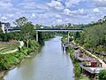
Road bridge across the Bremer River in Ipswich
|
|

Location of Bremer River river mouth in Queensland
|
|
| Country | Australia |
| State | Queensland |
| Region | Scenic Rim, South East Queensland |
| Cities | Ipswich, Brisbane |
| Physical characteristics | |
| Main source | Scenic Rim Main Range National Park 140 m (460 ft) 27°55′55″S 152°27′53″E / 27.93194°S 152.46472°E |
| River mouth | confluence with the Brisbane River Barellan Point 4 m (13 ft) 27°34′57″S 152°51′16″E / 27.58250°S 152.85444°E |
| Length | 100 km (62 mi) |
| Basin features | |
| River system | Brisbane River catchment |
| Basin size | 2,032 km2 (785 sq mi) |
| Tributaries |
|
| National park | Main Range National Park |
The Bremer River is a river in South East Queensland, Australia. It flows into the Brisbane River. The river is about 100-kilometre (62 mi) long. It collects water from an area of about 2,032 square kilometres (785 sq mi). This area includes many valleys in the Scenic Rim.
European explorers first saw the river in 1824. John Oxley and Allan Cunningham were among them. Oxley likely named it after Captain James Gordon Bremer. Captain Bremer was in charge of a ship called HMS Tamar.
Contents
Where Does the Bremer River Flow?

The Bremer River starts in the hills of the Scenic Rim. It flows past the town of Rosewood. Then it winds through the city of Ipswich.
The area where the river collects water is called its catchment. This catchment is surrounded by hills and ranges. To the west is the Little Liverpool Range. To the south and southwest is the Main Range. To the east are Flinders Peak and the Flinders Peak Group.
Many smaller streams flow into the Bremer River. These are called tributaries. Some of them are Deebing Creek, Bundamba Creek, and Warrill Creek. The town of Grandchester is on Western Creek. Rosevale is located near the river's upper parts.
A Look Back: History of the River

The Bremer River was first seen by Europeans in 1824. This happened when John Oxley and Allan Cunningham were exploring the Brisbane River. Oxley soon started calling it the Bremer River. He likely named it after Captain James Gordon Bremer.
The first European to travel along the river was Captain Patrick Logan. This was in 1826 or 1827. He found limestone deposits where Ipswich is now. But the river became shallow further upstream. So, he did not explore more.
Later, in 1828, Alan Cunningham explored the upper parts of the river. He was looking for a way to the Darling Downs. He made maps and sent them to the Governor.
In the past, the river was very important for travel. Before the railway line was built in 1875, people used boats. Paddle steamers carried people and goods between Ipswich and Brisbane.
An immigration depot was built on the riverbank in 1863. This helped new people arriving in Australia. They came to Ipswich by paddle steamer. The depot was used until 1900.
In 1995, the Bremer Catchment Association was started. This group helps local communities. They work on projects like planting trees and controlling weeds.
Challenges: The River's Health

The Bremer River has faced many challenges over time. Early photos from the 1870s show that trees along the riverbanks were cut down. This might have been for timber. It also made the river channel harder for boats.
The river often flows slowly. It can also flood sometimes. Sadly, it is known to be quite polluted. This means its water quality is not very good. The river does not get enough fresh water. This makes it hard to wash away dirt and pollution.
The water can be cloudy, which is called turbidity. It also has high levels of nutrients and bacteria. This is especially true where water from Ipswich flows into the river.
Efforts to improve the water quality began in 1973. Tests showed that pollution came from factories. For example, wool mills and meatworks released waste into the river.
In 1979, a survey found that the land around the river was also damaged. Most of the natural plants along the banks were gone. Weeds have grown in their place.
The river's water quality has been rated low by the Healthy Waterways group. For many years, it received an "F" grade. This is the lowest possible grade. The Ipswich City Council has tried to help. They increased fines for polluting the river. In 2013 and 2014, the grade improved slightly to a "D-".
In 2009, some heavy metals were found in Warrill Creek. This is a stream that flows into the Bremer. These metals came from the RAAF Base Amberley. However, they did not reach the main Bremer River. In 2010, a fund was started to help clean up the river.
One big problem for the river was an introduced plant called water hyacinth. It grew so thick that it sometimes blocked boats. There were big outbreaks in the early to mid-1900s.
Water for Life: Moogerah Dam
Moogerah Dam was built on Reynolds Creek. This creek is a tributary of the Bremer River. The dam provides drinking water for towns like Boonah. It also supplies water for irrigation. Farmers use this water for their crops and to water their cattle.
Images for kids
-
Road bridge across the Bremer River in Ipswich
-
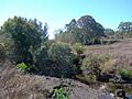
Upper river at Rosevale, 2011
-
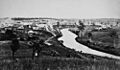
Bremer River at Ipswich in 1872
-
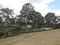
The river at Basin Pocket, 2015
