Rosewood, Queensland facts for kids
Quick facts for kids RosewoodIpswich, Queensland |
|||||||||||||||
|---|---|---|---|---|---|---|---|---|---|---|---|---|---|---|---|
 |
|||||||||||||||
| Population | 3,263 (2021 census) | ||||||||||||||
| • Density | 103.92/km2 (269.2/sq mi) | ||||||||||||||
| Postcode(s) | 4340 | ||||||||||||||
| Area | 31.4 km2 (12.1 sq mi) | ||||||||||||||
| Time zone | AEST (UTC+10:00) | ||||||||||||||
| Location |
|
||||||||||||||
| LGA(s) | City of Ipswich | ||||||||||||||
| State electorate(s) |
|
||||||||||||||
| Federal Division(s) | Blair | ||||||||||||||
|
|||||||||||||||
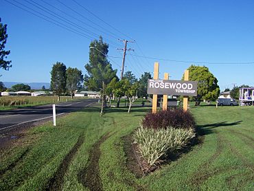
Rosewood is a small town and area located in the City of Ipswich, Queensland, Australia. It's a rural place, meaning it's surrounded by countryside. In 2021, about 3,263 people lived in Rosewood.
Contents
Rosewood's Location and Landscape
Rosewood is found in the Bremer Valley. It's about 60 kilometers (37 miles) southwest of Brisbane city. It's also only 19 kilometers (12 miles) from Ipswich.
The Bremer River forms part of the town's southern border. To the north, you'll find the Little Liverpool Range. A hill called Perrys Knob is also in Rosewood. It rises 292 meters (958 feet) above sea level. This hill is named after the Perry family, who used to own land there.
Railways in Rosewood
The main railway line goes through Rosewood. It enters from the east and leaves to the west. Rosewood has its own railway station, which is still in use today. There was once another station called Yarrowlea, but it's now abandoned.
There were also two railway stations on a line that is now closed. These were Perrys Knob railway station and North Rosewood railway station.
Rosewood's Past and Growth
The name Rosewood likely comes from a type of tree. These trees, either the Rosewood acacia or a mahogany species, were common in the area. The first owners of the town's land were William Mathews and Foote Moore.
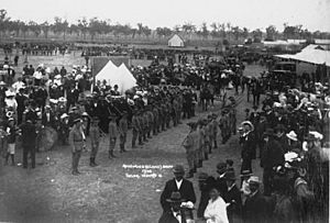
The railway first came through Rosewood in 1865. This helped the town grow and connect with other places.
Schools and Churches
Rosewood Provisional School opened its doors on October 17, 1870. It became Rosewood State School in 1875. Later, in 1962, it started offering secondary education. A separate high school was built in 1980.
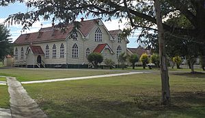
St. Brigid’s Church was opened in 1910. It replaced an older wooden church. St Brigid's Catholic Primary School began in 1922. It was started by the Sisters of Mercy, who taught there until 2011. The school still follows their values.
A new Church of Christ chapel opened in 1923. The old building was moved and used as a home.
Mining and Motor Racing
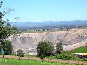
Coal mining started in the area west of Rosewood in 1918. Two railway lines were built to connect the mines to the main railway. The New Oakleigh Mine was one of the last coal mines in the area. It closed in 2013.
In the late 1930s, a special track for motor racing was built in Rosewood. It was the first of its kind in Queensland, Australia. The track was mostly used for motorcycle races. It was a dirt track, and no signs of it remain today.
St Brigid's Church Repairs
St Brigid's Catholic Church has been leaning for many years. By 2020, it was considered unsafe and had to close. It needs about $3 million in repairs to make it safe again. As of early 2022, the repair work had not yet started.
Who Lives in Rosewood?
In 2021, Rosewood had a population of 3,263 people. Slightly more than half (53.4%) were female, and 46.6% were male. The average age of people in Rosewood was 39 years old.
Most people (83.5%) living in Rosewood were born in Australia. Other countries of birth included England (2.8%) and New Zealand (2.1%). Most people (87.8%) spoke only English at home.
Important Places in Rosewood
Rosewood has several places that are important for their history. These are called heritage-listed sites. They include:
- The Rosewood Courthouse at 1 John Street.
- Glendalough, a historic house at 96 John Street.
- St Brigids Catholic Church at 11 Railway Street.
Learning in Rosewood
Rosewood has several schools for different age groups.
Primary Schools
Rosewood State School is a government primary school for students from Prep to Year 6. It's located on School Street. In 2018, it had 284 students.
St Brigid's Primary School is a Catholic primary school. It also teaches students from Prep to Year 6. This school is on Railway Street. In 2018, it had 161 students.
High School
Rosewood State High School is a government secondary school. It teaches students from Year 7 to Year 12. You can find it on Lanefield Road. In 2018, the high school had 455 students. It also has a special program for students with special education needs.
Community Services in Rosewood
Rosewood offers several services for its community members.
Library and Community Groups
The Ipswich City Council runs the Rosewood public library. It's located at 15 Railway Street.
The Rosewood branch of the Queensland Country Women's Association (QCWA) meets at 4 John Street. This group helps women in rural areas.
Churches in Rosewood
There are many churches in Rosewood, including:
- St Luke's Anglican Church at 72-74 John Street.
- St Brigid's Catholic Church at 11 Railway Street.
- Rosewood Uniting Church at 21 John Street.
- Rosewood Baptist Church at 84 John Street.
- St Matthew's Lutheran Church at 63 Matthew Street.
Getting Around Rosewood
Rosewood is the end point for the Queensland Rail City network's Ipswich and Rosewood railway line. The Rosewood railway station offers train services to Ipswich and Brisbane.
Translink also provides bus route 539. This bus route connects Rosewood to other towns in the Lockyer Valley, like Laidley and Gatton.
 | Anna J. Cooper |
 | Mary McLeod Bethune |
 | Lillie Mae Bradford |


