Jeebropilly, Queensland facts for kids
Quick facts for kids JeebropillyIpswich, Queensland |
|||||||||||||||
|---|---|---|---|---|---|---|---|---|---|---|---|---|---|---|---|

Stone Quarry Cemetery, 2010
|
|||||||||||||||
| Population | 0 (2021 census) | ||||||||||||||
| • Density | 0/km2 (0/sq mi) | ||||||||||||||
| Postcode(s) | 4340 | ||||||||||||||
| Area | 11.7 km2 (4.5 sq mi) | ||||||||||||||
| Time zone | AEST (UTC+10:00) | ||||||||||||||
| Location |
|
||||||||||||||
| LGA(s) | City of Ipswich | ||||||||||||||
| State electorate(s) | Scenic Rim | ||||||||||||||
| Federal Division(s) | Blair | ||||||||||||||
|
|||||||||||||||
Jeebropilly is a quiet rural area located in Queensland, Australia. It's part of the City of Ipswich. This area was once known as Stone Quarry. In 2021, the official count showed that Jeebropilly had very few people living there, or even no one at all!
Contents
Exploring Jeebropilly's Landscape
Jeebropilly has some interesting natural boundaries. The Bremer River flows along its western and northern sides. This river helps shape the edge of the area.
The Important Railway Line
To the south-west and south, Jeebropilly is bordered by a special railway line. It's called the Yarrowlea–Ebenezer railway line. This line is a branch of the main railway system. It's super important because it connects to the Jeebropilly coal mine. Coal from this mine is transported on this line. It then goes all the way to the Port of Brisbane to be shipped to other places.
You might find it interesting that the Ebenezer railway station is actually located within Jeebropilly. It's on Coopers Road, right before the end of the line where trains can turn around.
A Look Back at Jeebropilly's Past
The name Jeebropilly comes from the Ugarapul language. It means "flying squirrel gully." This tells us a bit about the local wildlife that might have been common here long ago.
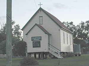
The Bethlehem Lutheran Church
A church called Bethlehem Lutheran Church first opened its doors in Jeebropilly on April 19, 1871. Later, a new church building was built on April 20, 1898. However, the church closed around 1938.
What happened to the building? In 1940, the church building was carefully moved to another town called Toogoolawah. There, it reopened as the Cornerstone Lutheran Church. This shows how old buildings can sometimes be given a new life in a different place!
The Railway's Arrival
The Yarrowlea–Ebenezer railway line, which is so important for the coal mine, officially opened on February 1, 1990. This was a big step for the area's economy.
Who Lives in Jeebropilly?
In 2016, there were only 7 people living in Jeebropilly. By 2021, the population was recorded as "no people or a very low population." This means it's a very quiet place with very few residents.
Jeebropilly's Economy
The main economic activity in Jeebropilly is coal mining. New Hope Corporation Ltd has restarted mining coal at its Jeebropilly coal mine. They had closed it down in 2007, but now it's active again. This mine plays a big role in the local economy.
Schools Near Jeebropilly
There are no schools located directly within Jeebropilly itself. However, students living in the area can attend schools in nearby towns.
Primary Schools
The closest government primary schools are:
- Rosewood State School in Rosewood (to the west)
- Walloon State School in Walloon (to the north)
- Amberley District State School in Yamanto (to the east)
Secondary Schools
For high school, students can go to:
- Rosewood State High School in Rosewood (to the west)
- Bremer State High School in Ipswich CBD (to the east)
Local Spots and Facilities
Even though it's a quiet area, Jeebropilly has a couple of notable spots.
Mcgearys Road Reserve
This is a park where people can enjoy the outdoors. It's a nice green space in the locality.
Stone Quarry Cemetery
Also known as Jeebropilly General Cemetery, this is a cemetery in the area. It's a place where people are laid to rest.
 | Aurelia Browder |
 | Nannie Helen Burroughs |
 | Michelle Alexander |


