
Laidley, Queensland facts for kids
Quick facts for kids LaidleyQueensland |
|||||||||||||||
|---|---|---|---|---|---|---|---|---|---|---|---|---|---|---|---|

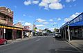
Main Street of Laidley, 2011
|
|||||||||||||||

Laidley
Location in Queensland
|
|||||||||||||||
| Population | 3,809 (2021 census) | ||||||||||||||
| • Density | 214.0/km2 (554/sq mi) | ||||||||||||||
| Established | 1858 | ||||||||||||||
| Postcode(s) | 4341 | ||||||||||||||
| Area | 17.8 km2 (6.9 sq mi) | ||||||||||||||
| Time zone | AEST (UTC+10:00) | ||||||||||||||
| Location | |||||||||||||||
| LGA(s) | Lockyer Valley Region | ||||||||||||||
| County | Churchill | ||||||||||||||
| Parish | Laidley | ||||||||||||||
| State electorate(s) | Lockyer | ||||||||||||||
| Federal Division(s) | Wright | ||||||||||||||
|
|||||||||||||||
|
|||||||||||||||
Laidley is a friendly rural town located in the beautiful Lockyer Valley Region of Queensland, Australia. It's a place where about 3,809 people call home, according to the 2021 census.
Contents
Laidley's Location and Landscape
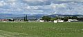
Laidley is found in the Lockyer Valley area of South East Queensland. It sits east of the Great Dividing Range and near the northern hills of the Main Range. The town is about 84 kilometers (52 miles) west of Brisbane, Queensland's capital city. It's also about 57 kilometers (35 miles) east of Toowoomba.
The Warrego Highway (A2) is about 10 kilometers (6 miles) north of Laidley. The town is also on the main railway line that connects Brisbane to Charleville. The Laidley–Plainland Road goes north from the town.
The Lockyer Creek Catchment
Laidley is in the Lockyer Creek area, where water flows into the creek. This creek starts on the eastern slopes of the Great Dividing Range and flows east. The whole area that drains into the creek is about 3,000 square kilometers (1,158 square miles). The land height ranges from 1,100 meters (3,600 feet) on the Great Dividing Range to 24 meters (79 feet) where it meets the Brisbane River.
Queensland's Country Garden
The Lockyer Valley has flat land, rich soil, and a warm climate. These conditions make it perfect for growing lots of vegetables, fruits, and grains. Since the late 1800s, farming has been the main industry here. The Lockyer Valley produces 35% of Queensland's vegetables, and Laidley is often called "Queensland's Country Garden."
Farmers in Laidley grow many different crops. Some of the most common vegetables are carrots, potatoes, cabbage, broccoli, cauliflower, pumpkins, corn, and beans. A lot of the beetroot grown in Australia comes from the Laidley area.
A Glimpse into Laidley's Past

The land around Laidley was originally home to the Kitabul People. Today, the Ugarapul People are the traditional owners of the Lockyer Valley.
In 1829, an explorer named Allan Cunningham explored this area. On June 22, 1829, he named it Laidley Plains. He named it after James Laidley, who was an important official in the colony of New South Wales.
The town of Laidley grew up around a place where wagons would stop. This stop was on the main road between Ipswich and Toowoomba. Travelers needed a break after climbing over the small Little Liverpool Range west of Marburg.
By the 1850s, people started clearing the land for sheep farming. A survey was done in 1858 to plan the growing village.
Early Services and Buildings
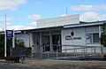
Laidley's Post Office first opened on February 1, 1861. Police officers have been stationed in Laidley since 1863. The first two police officers were Acting Sergeant William Gunn and Constable Thomas Raleigh. Today, the Police Station is in a renovated building on Spicer Street. This building used to be the Laidley Courthouse and Public Offices, opened in 1964.
The first Presbyterian church service in Laidley was held in 1864. The railway line from Grandchester reached a railway station about 1.5 kilometers (0.9 miles) north of the town in the mid-1860s.
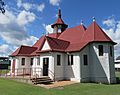
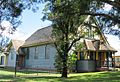
St Saviour's Anglican Church opened in Laidley on April 28, 1886. A new, stronger St Saviour's Anglican Church was built from reinforced concrete and opened on June 21, 1910.
Schools and Hospitals
Laidley Old Township Provisional School opened on March 9, 1908. It later became Laidley Central State School. This school closed in 1998 and was replaced by Laidley District State School at a new location. The old school buildings are now a childcare center, and the grounds are a cricket oval.
St Mary's Catholic Primary School was started by the Sisters of Mercy. It officially opened on July 14, 1912. The Sisters ran the school until 1988.
The "Lockyer General Hospital" officially opened in Laidley on March 6, 1915. It moved to its current location between Spicer Street and William Street in 1922, reopening on June 23, 1923.
Museums and Modern Times


The Laidley Pioneer Village and Museum opened in 1972. It was built on the site where horses from Cobb & Co stagecoaches used to rest. It was the first heritage village of its kind in Queensland.
Laidley State High School opened on January 29, 1985. In 1998, the Das Neumann Haus Museum opened to the public. It's an historic house museum that also has a visitor information center, a cafe, and a gift shop.
Laidley used to be the center of the Shire of Laidley until 2008. Then, it became part of the new Lockyer Valley Region local government area. The Laidley public library opened in 2017.
Laidley's People
In the 2021 census, the town of Laidley had a population of 3,809 people. In 2016, about 4.8% of the people identified as Aboriginal or Torres Strait Islander. Most people (79.6%) were born in Australia. The next most common birthplaces were England and New Zealand. Most people (87.3%) spoke only English at home.
Many people in Laidley work in farming, trades, or community services.
Historic Places to See

Laidley has several places that are listed for their historical importance. These include:
- The old Corduroy Road Remains on Toowoomba-Ipswich Road.
- Whitehouse's Bakery at 91 Patrick Street.
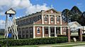
- The Exchange Hotel at 134 - 138 Patrick Street.
- The G Wyman Building at 140 - 142 Patrick Street.
- The Das Neumann Haus Museum at the corner of William Street and Patrick Street.
Fun Things to Do in Laidley
- The Laidley Pioneer Village and Museum at 92 Drayton Street is a great place to learn about the past.
- The Das Neumann Haus Museum at the corner of William Street and Patrick Street offers a look into a historic home.
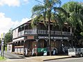
- You can also visit the Queensland National Hotel at 90 Patrick Street.
Laidley's Weather
The Lockyer Valley is the driest part of the South East Queensland region. Laidley has a humid subtropical climate. This means it has long, hot, and rainy summers, and mild, sunny winters. Thunderstorms are common in summer, and you might see some frost in winter.
| Climate data for nearest weather station - University of QLD Gatton | |||||||||||||
|---|---|---|---|---|---|---|---|---|---|---|---|---|---|
| Month | Jan | Feb | Mar | Apr | May | Jun | Jul | Aug | Sep | Oct | Nov | Dec | Year |
| Record high °C (°F) | 44.5 (112.1) |
45.7 (114.3) |
41.1 (106.0) |
37.4 (99.3) |
33.7 (92.7) |
31.5 (88.7) |
29.0 (84.2) |
37.9 (100.2) |
39.5 (103.1) |
41.6 (106.9) |
42.8 (109.0) |
43.5 (110.3) |
45.7 (114.3) |
| Mean daily maximum °C (°F) | 31.6 (88.9) |
30.8 (87.4) |
29.6 (85.3) |
27.2 (81.0) |
23.8 (74.8) |
21.1 (70.0) |
20.8 (69.4) |
22.5 (72.5) |
25.6 (78.1) |
28.2 (82.8) |
30.2 (86.4) |
31.4 (88.5) |
26.9 (80.4) |
| Mean daily minimum °C (°F) | 19.1 (66.4) |
19.0 (66.2) |
17.4 (63.3) |
13.7 (56.7) |
10.2 (50.4) |
7.6 (45.7) |
6.3 (43.3) |
6.7 (44.1) |
9.5 (49.1) |
13.2 (55.8) |
16.0 (60.8) |
18.1 (64.6) |
13.1 (55.6) |
| Record low °C (°F) | 11.9 (53.4) |
8.3 (46.9) |
6.7 (44.1) |
3.2 (37.8) |
−0.2 (31.6) |
−2.4 (27.7) |
−5.6 (21.9) |
−1.9 (28.6) |
0.0 (32.0) |
4.3 (39.7) |
6.3 (43.3) |
8.8 (47.8) |
−5.6 (21.9) |
| Average precipitation mm (inches) | 109.4 (4.31) |
99.5 (3.92) |
79.2 (3.12) |
48.0 (1.89) |
45.3 (1.78) |
41.2 (1.62) |
36.4 (1.43) |
26.4 (1.04) |
34.4 (1.35) |
65.2 (2.57) |
77.3 (3.04) |
98.2 (3.87) |
765.6 (30.14) |
| Average precipitation days | 10.1 | 9.9 | 10.0 | 6.7 | 6.5 | 5.8 | 5.6 | 5.1 | 5.4 | 7.7 | 8.3 | 9.6 | 90.7 |
Sports and Recreation

The Laidley Sports and Recreation Reserve is the main place for sports in Laidley. Here, you can play netball, soccer, rugby league, and touch football. There's also a gym and walking paths.
For swimming, visit the Dal Ryan War Memorial Pool at 44 John Street. It has a 25-meter pool with six lanes and a separate pool for children. You'll also find barbecue facilities and a snack bar.
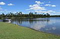
The Laidley Golf Club has a twelve-hole course next to Lake Dyer. It's about two kilometers from Laidley.
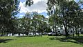
Lake Dyer Caravan & Camping Ground is right on the shore of Lake Dyer. The lake is open to the public for fun activities like fishing and boating.
Education in Laidley
Laidley has several schools for young people:
- Laidley District State School is a government primary school for students from Early Childhood to Year 6. It's located at 232 Patrick Street. In 2018, about 379 students attended this school. It also has a special education program.
- St Mary's School is a Catholic primary school for students from Prep to Year 6. It's on John Street. In 2017, about 267 students were enrolled here.
- Laidley State High School is a government secondary school for students from Year 7 to Year 12. It's located at 98 Alfred Street. In 2018, about 699 students attended this high school. It also offers a special education program.
Community Services and Churches
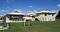
The Lockyer Valley Regional Council has a customer service center and a public library on Spicer Street.
Laidley Hospital and Community Health Services is at 75 William Street. It offers general care, emergency services, and other health programs. The Meals on Wheels service also operates from here.
The Laidley show grounds are managed by the Laidley Show Society. They host the annual Laidley Show for two days in July. The grounds can also be rented for events and are open for camping.
Laidley has several churches:
- St Saviour's Anglican Church at 28 Ambrose Street.
- St Patrick's Catholic Church at 1-3 John Street South.
- Laidley Uniting Church at 45 Patrick Street.
- Redeemer Lutheran Church Laidley at 21 Patrick Street.
Images for kids
-
Laidley main street, Patrick Street, April 2022
-
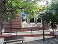
Laidley Post Office, April 2022
-
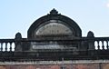
Giesemann's Buildings 1902, Patrick St, April 2022
-
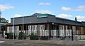
Lockyer Valley Regional Council customer service centre and library, April 2022
-
Laidley Hospital, April 2022
-
Laidley Police Station, April 2022
-
Lake Dyer camping ground, April 2022
-
Lake Dyer, April 2022
-
Laidley QLD rural landscape, April 2022
-
Laidley Queensland National Hotel, April 2022
-
St Saviour's Anglican Church, April 2022
-
St Patrick's Catholic Church, April 2022
-
Uniting Church, April 2022


