
Main Range National Park facts for kids
Quick facts for kids Main Range National ParkQueensland |
|
|---|---|
|
IUCN Category II (National Park)
|
|

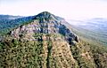
The forested slopes of Main Range to the south of Lake Moogerah.
|
|

Main Range National Park
Location in Queensland
|
|
| Nearest town or city | Warwick |
| Established | 1965 |
| Area | 301.7 km2 (116.5 sq mi) |
| Managing authorities | Queensland Parks and Wildlife Service |
| Website | Main Range National Park |
| See also | Protected areas of Queensland |
The Main Range National Park is a special place in Queensland, Australia. It's a huge area of mountains and forests. You can find it about 85 kilometers (53 miles) southwest of Brisbane.
This park is part of something even bigger: the Gondwana Rainforests of Australia. This is a World Heritage Site, which means it's super important for the whole world! The park protects a large part of the beautiful mountains in South East Queensland, including the biggest rainforest area there. It's also an Important Bird Area, helping to protect many amazing and sometimes rare birds.
Contents
Discovering Main Range National Park

Main Range National Park stretches a long way. It goes from Kangaroo Mountain all the way south to Wilsons Peak, which is on the border with New South Wales. Inside the park, you'll find Mount Superbus. This mountain is 1,375 meters (4,511 feet) tall and is the highest peak in South East Queensland!
Many other peaks are also in the park. These include Bare Rock, Mount Cordeaux, Mount Mitchell, Spicers Peak, and Mount Mistake. In total, there are more than 40 mountains here that are taller than 1,000 meters (3,280 feet).
The park is a great place for outdoor fun. You can go bushwalking on many tracks. There are also places to go camping and have a picnic. Some popular spots for these activities are Spicers Gap, Cunninghams Gap, and Queen Mary Falls.
How the Mountains Formed
The Main Range mountains were created by ancient volcanoes. These volcanoes erupted a very long time ago, between 25 and 22 million years ago! Instead of forming one big volcano, the lava flowed out from many cracks in the ground.
These lava flows created layers of rock, mostly basalt. Over millions of years, these layers formed the mountains you see today. They make up the Main Range, the Little Liverpool Range, and the Mistake Range.
Amazing Plants and Animals

The steep slopes of the Main Range have kept their natural forests safe. This means they are a perfect home for many animals. The park has two main types of plants: thick sub-tropical rainforest and dry sclerophyll forest.
These forests are home to many special creatures. Some birds, like the eastern bristlebird, Coxen's fig parrot, and the black-breasted buttonquail, are very rare and need protection. You might even spot the rare red goshawk flying high above.
The park also protects some endangered animals. These include the giant barred frog, Fleay's barred frog, spotted-tailed quoll, and the Hastings River mouse. These animals used to be more common in the Goomburra part of the park.
A Look Back in Time: Park History
Spicers Gap is a very old pathway. It's believed that Indigenous Australians used this route for thousands of years. They traveled between the inland areas and the coast.
In 1828, a botanist named Allan Cunningham officially found the route through the mountains. This route is now called Cunninghams Gap. Later, in 1847, a stockman named Henry Alphen discovered Spicers Gap. The Spicers Gap Road was built to move supplies. It's a great example of old engineering in Queensland.
In 1840, an early settler named George Elphinstone Dalrymple settled in the Goomburra Valley. Dalrymple Creek is named after him. In 1909, the area around Cunninghams Gap became a national park.
The park grew even bigger in 1994. The Goomburra Forest Reserve became part of Main Range National Park. This also meant it was added to the Central Eastern Rainforest Reserves of Australia, which is a World Heritage Site. In 2007, the entire Gondwana Rainforests of Australia was added to the Australian National Heritage List.
Special Heritage Sites
Main Range National Park has some places that are listed as important heritage sites. These include parts of the Spicers Gap Road. This old road is now within the Spicers Gap Road Conservation Park.
Images for kids
-
Near Cunninghams Gap, Mount Mitchell rises to an elevation of 1168 m.

See also
 In Spanish: Parque nacional Cadena Principal para niños
