
Spicers Gap Road facts for kids
Quick facts for kids Spicers Gap Road |
|
|---|---|

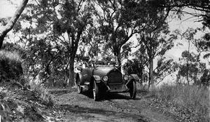
Spicers Gap Road, eastern approach, 2017
|
|
| Location | Spicers Gap Road Conservation Park (with Main Range National Park), Tregony, Southern Downs Region, Queensland, Australia |
| Design period | 1840s - 1860s (mid-19th century) |
| Built | 1859 - 1865 |
| Official name: Spicers Gap Road Conservation Park, Spicers Gap Road, Spicers Peak Road | |
| Type | state heritage (built, landscape) |
| Designated | 23 July 1999 |
| Reference no. | 601732 |
| Significant period | 1850s-1870s, 1930s-1940s (historical) 1859-ongoing (social) |
| Significant components | quarry, views to, culvert - storm water, drain - storm water, road/roadway, views from, pole/s - telegraph |
| Lua error in Module:Location_map at line 420: attempt to index field 'wikibase' (a nil value). | |
Spicers Gap Road is a special, old road in Queensland, Australia. It's located in the Spicers Gap Road Conservation Park, which is part of the Main Range National Park, near a place called Tregony. This road was built a long time ago, between 1859 and 1865. It's also known as Spicers Gap Road Conservation Park and Spicers Peak Road. Because of its history, it was added to the Queensland Heritage Register on July 23, 1999.
Contents
The Road's Early History
Discovering the Route
In 1824, an explorer named Allan Cunningham was exploring the Brisbane River. He saw a mountain range to the southwest. Later, in 1827, Cunningham led a group to explore the land beyond these mountains.
He came from the south, from a place called New England. On June 5, 1827, Cunningham became the first European to find the Darling Downs. This was a large area of good land for farming.
On June 11, 1827, Cunningham found a possible path through the mountains to the coast. This path later became known as Spicers Gap. He went back to Sydney and told Governor Ralph Darling about the good land and the possible route to Moreton Bay.
In 1828, Cunningham went back to Moreton Bay to find the pass again. He traveled southwest from Ipswich and found Cunningham's Gap on August 21, 1828. He thought this might not be the same pass he found in 1827. He looked further north but couldn't find the other pass. So, he thought Cunningham's Gap must be the one he found earlier.
Cunningham told the government that this pass was important for connecting the coast with the large farming areas to the west. But it wasn't until the late 1830s and early 1840s that farmers started using the Darling Downs.
Challenges for Early Settlers
The Leslie Brothers were among the first to settle in the southern Darling Downs in 1840. Many other farmers followed. These farmers had a big problem: it was a very long trip, about 800 kilometres (500 mi), to take their wool to the port in Maitland. They also needed to bring supplies back.
They needed a direct route to the Moreton Bay settlement (which is now Brisbane). In 1840, Leslie and Hodgson got permission to send supplies to Brisbane. But they still struggled to get their goods over the mountains to the Darling Downs.
Cunningham's Gap was very hard for heavy wagons to cross. People looked for other paths. Some other routes included Gorman's Gap and Hodgson's Gap.
Rediscovering Spicers Gap
Farmers in the Warwick area kept looking for a better southern pass. In April 1847, Henry Alphen rediscovered the pass that Cunningham had found in 1827. This pass was between Mount Mitchell and Spicers Peak.
Spicers Peak was named by Cunningham after Peter Beauclerk Spicer. He was a supervisor of convicts who found the mountain while looking for escaped prisoners. Mount Mitchell was named after explorer Thomas Mitchell. Spicers Gap was about 4 kilometres (2.5 mi) south of Cunningham's Gap.
The discovery was announced in the newspaper, the Moreton Bay Courier. People asked for a road to be built through Spicers Gap. Not many people offered money, so farmers Patrick Leslie and Fred Bracker paid most of the cost. They cleared the road and laid a surface of pine logs, called a "corduroy" road. By early August, two wagons had used the new road to Ipswich. This saved them three days and about 100 kilometres (62 mi) of travel.
Around this time, inns (like hotels) started to open for travelers. Two inns were built along the new road. One was Balbi's at Clumber, and the other was the Main Range Hotel. Henry Alphen, who rediscovered the pass, was rewarded by the government. He built a public house called Alphen's Inn or the Woolpack Inn. It was later taken over by William Jubb in 1851. But in 1858, the inn was taken apart because of land ownership problems.

Improving the Road
In the 1850s, people tried to make the road better. Edward Moss was hired to improve a section east of Governor's Chair. He used logs for the road's base, but this "corduroy road" soon fell apart. This made the road even harder to use. Even though Moss didn't finish his work, a fresh water spring there is still called Moss's Well after him.
By 1857, it took a team of up to 60 bullocks (male cows) to pull a wagon full of wool through the tough parts of the road. The government in New South Wales (which Queensland was part of then) started thinking about roads in the Moreton Bay area. In 1856, they gave £3500 for road work.
By January 1859, the New South Wales government was planning more work on Spicers Peak Road. The Minister for Public Works approved £1200 for construction. The work wasn't finished by December 1859. From then on, the new Government of Queensland became responsible for the road.
Building a Proper Road
One of the first things the new Queensland Parliament did was to set up a committee. This committee looked into how to improve travel in the colony. Experts like FE Roberts, the Surveyor of Roads, and Augustus Charles Gregory, the Surveyor-General, gave advice.
The government decided to look closely at both Cunningham's Gap and Spicers Peak Pass. On August 25, 1860, Surveyor Austin reported that Spicers Peak Pass was better than Cunningham's Gap. He said it would take him about a month to survey the new route. On October 6, 1860, Austin confirmed he had finished surveying the new line through Spicers Peak Pass.
Between 1860 and 1865, a properly designed road was built. Much of the road we see today was built under the direction of Robert Austin, who was a surveyor and later an Engineer of Works. Henry Clinton, the Clerk of Works, supervised up to 90 workers.
Road Building Techniques
- Stone Pitching: In steep areas, large stones were carefully placed by hand. Smaller stones were then wedged between them to create a very strong road surface.
- Macadamising: In other parts, broken stones were used as a base and surface. This method, called "macadamising," was invented by a British engineer named John MacAdam.
- Corduroy Roads: Sometimes, logs were laid side by side to make a solid base. This was often used to fix muddy parts of the road. In 1854, Nehemiah Bartley described the corduroy road at Spicers Peak as a "bottomless morass" (a swamp) where the logs had rotted. It was very difficult for horses or wagons to cross.
Drainage Systems
Good drainage was very important for Austin's road design. Drains up to one meter deep were dug on both sides of the road. On steep slopes, the road was cut into the side of the hill to create a "benched" road.
Sometimes, water from the drain on the higher side of a benched road needed to cross the road. This was done using small earth banks called "whoaboys." These banks also slowed down the water to prevent erosion. The name "whoaboy" is said to come from what drivers would shout to their horses when approaching these banks.
Austin's improvements meant that horse teams could now use the road instead of slower bullock teams. The Gap was used by heavy traffic for a short time in the 1860s. But this didn't last long.
The Railway Arrives
When the railway line reached Warwick from Brisbane (via Toowoomba) in 1871, Spicers Gap Road was almost completely abandoned. Moving goods by train was much faster and more efficient than by wagons and teams.
After local governments were set up in 1879, the responsibility for roads went to the Boonah and Glengallan Divisional Boards. Around the turn of the century, there was a time of economic hardship, drought, and floods. The road didn't bring in money for the local councils, so they spent very little on keeping it in good condition.
A New Life for the Road
Interest in the road came back after 1910 with the invention of the motor car. People started to enjoy driving for fun. Local councils were asked to fix the road, but it wasn't always easy to travel on.
In 1925-27, communities from the Darling Downs and Fassifern Valley worked together to build a road through Cunningham's Gap. There was a debate about whether the main route should go through Cunningham's or Spicers Gaps. In 1935, the Cunningham's Gap route was upgraded to a highway.
The Telegraph Line
Until 1973, Spicers Gap Road was important for the main telegraph link between Brisbane and New South Wales. In 1861, the first telegraph line was built, connecting New South Wales and Queensland. The section over Spicers Gap Road connected the first telegraph station at Fassifern Reserve with the station at Tregony.
In 1866, another line was added between Brisbane and Stanthorpe. By 1905, there were five telegraph wires on the line. In the 1920s, the iron wires were replaced with copper. The telegraph line stopped working in 1973 and was removed in 1975.
Spicers Gap Road was kept in good condition until the Cunningham Highway was finished. Governor's Chair became a popular place for picnics in the 1930s and 1940s, and it still is today. Spicers Gap Road was officially opened as a historic road on August 23, 1992. In 1998, the historic road was made a Conservation Park.
What Spicers Gap Road Looks Like Today

Spicers Gap Road is partly inside Main Range National Park. It crosses the Great Dividing Range about four kilometers south of Cunninghams Gap. The part of the road within Main Range National Park is about 4,500 metres (14,800 ft) long. About 1,600 metres (5,200 ft) of Spicers Gap Road has been named the Spicers Gap Road Conservation Park. This part of the road is forty meters wide and runs between Governor's Chair (also called Devil's Elbow) and the western edge of the park.
You can still see different road surfaces that were used to solve problems during its building:
- Macadamised surfacing: This is a type of road made from broken stones.
- Corduroy surfacing: This is found in two areas, 560 and 765 metres (1,837 and 2,510 ft) west of Devil's Elbow. It's made of logs laid side by side.
- Stone pitching: This is found in many places and is still in excellent condition. It's made of carefully placed large stones.
You can also see old engineering features like:
- Inverts: These are shallow drains that direct water across the road.
- Whoaboys: The remains of one whoaboy are located 868 metres (2,848 ft) west of Devil's Elbow.
- Diversionary drainage systems: These are systems to move water away from the road.
- Over one kilometer of the road is "benched," meaning it was cut into the side of the mountain.
- Some of the original marks from picks and chisels can still be seen on a section of rock 65 metres (213 ft) west of Devil's Elbow.
Other features along the road include:
- Old stone quarries where rocks were taken out.
- Side cuttings (parts where the hill was cut away).
- A system of catch drains and culverts (tunnels for water) along the whole road. These drains are about 50–75 centimetres (20–30 in) wide and 20–25 centimetres (7.9–9.8 in) deep. Some of them are lined with stone.
Some parts of the road have been damaged by four-wheel driving, especially some culverts and the stone surfaces. However, about 1,100 metres (3,600 ft) of the road is in fair to excellent condition. Many of the old features are in good to excellent shape. You can also find the remains of old telegraph poles, insulators, and wire along the route of Spicers Gap Road.
Why Spicers Gap Road is Important
Spicers Gap Road Conservation Park was added to the Queensland Heritage Register on July 23, 1999, because it meets several important criteria:
- Shows Queensland's History: Built in 1847, with major work in the 1860s, Spicers Gap Road shows how Queensland's transport system grew. It was one of the first big public projects of the new Queensland colony after it separated from New South Wales. From the 1850s to the 1870s, it was the main way to travel from the Southern Darling Downs to Ipswich.
- Telegraph Line History: Spicers Gap Road is also important because it was where the telegraph line ran for 112 years (from 1861 to 1973). This line carried messages between states and was the first telegraph line from Brisbane to Sydney.
- Important People: The road is linked to surveyor and engineer Robert Austin, who led the main construction work in the 1860s.
- Rare Engineering: The road was designed with gentle curves and low slopes for the heavy wagons of that time. It's a rare example of 1860s engineering. Its features, like the drains and culverts, show great technical skill.
- Potential for Information: Spicers Gap Road can still teach us more about 19th-century engineering methods.
- Beautiful Scenery: Located in the Main Range National Park, Spicers Gap Road is beautiful. In some areas, it still feels wild and remote.
- Creative and Technical Achievement: The road shows a high level of creative and technical skill from that time. Its design for heavy transport and its engineering features are very impressive.
- Community Connection: Spicers Gap Road is important to the people in the area. It is well known and a popular place for tourists to visit.
