
Thomas Mitchell (explorer) facts for kids
Quick facts for kids
Sir
Thomas Mitchell
|
|
|---|---|

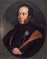
Portrait of Major Sir Thomas Mitchell (c. 1830s)
|
|
| Born |
Thomas Livingstone Mitchell
15 June 1792 |
| Died | 5 October 1855 (aged 63) |
| Resting place | Camperdown Cemetery, Newtown, New South Wales, Australia |
| Nationality | Scottish |
| Education | Doctor of Civil Law |
| Alma mater | Oxford University |
| Occupation | Surveyor, explorer |
| Known for | Explorations of south-eastern Australia, Wyld's Atlas |
| Title | Lieutenant colonel Sir |
| Spouse(s) | Mary Blunt |
| Children | 12 |
| Awards | Knighthood |
Sir Thomas Livingstone Mitchell (born 15 June 1792 – died 5 October 1855) was an important surveyor and explorer in southeastern Australia. He was born in Grangemouth, Scotland. In 1827, he became the Assistant Surveyor General of New South Wales. The next year, he became the Surveyor General, a job he held until he died. Mitchell was given a special honour, a knighthood, in 1839 for his great work in mapping Australia.
Contents
Early Life and Military Career
Thomas Mitchell was born in Scotland on 15 June 1792. His uncle, Thomas Livingstone, raised him from a young age.
When he was sixteen, after his uncle passed away, Mitchell joined the British army as a volunteer in the Peninsular War in Portugal. He became a Second Lieutenant in the 95th Rifles when he was nineteen. Mitchell was very good at drawing maps and plans, so he often worked in the army's mapping department. He was part of several important battles and sieges. For his service, he later received the Military General Service Medal.
After the war, Mitchell stayed in Spain and Portugal for four years. His job was to finish drawing maps of the battlefields and complete other important surveys. In 1818, he married Mary Blunt in Lisbon. He then returned to Britain and worked on his drawings. Later, in 1841, his detailed maps of the Peninsular War were published in an Atlas. These drawings are still a main source for understanding the geography of the war.
Surveyor General in New South Wales
In 1827, Mitchell moved to New South Wales in Australia. He became the Assistant Surveyor General. When the Surveyor General, John Oxley, died the next year, Mitchell took over the top job on 27 May 1828.
As Surveyor General, Mitchell greatly improved the quality and accuracy of surveying. This was very important because large areas of land were being opened up and sold to new settlers. Some of the first roads surveyed under his leadership were the Great North Road and the Great South Road (now the Hume Highway). These roads were built by convicts and connected Sydney to other important areas. Mitchell also kept detailed records of his work, including sketches and plans of Sydney and the Blue Mountains.
He also completed maps of Sydney, including Darling Point and Port Jackson. In 1834, he was asked to map the Nineteen Counties. His map was so skilled and accurate that he was awarded a knighthood.
During his time in New South Wales, Mitchell led four major expeditions to explore the inner parts of eastern Australia.
First Expedition: The Kindur River
In 1831, Mitchell went on his first expedition. He wanted to check a claim made by a runaway convict named George "The Barber" Clarke. Clarke said there was a large river called Kindur that flowed northwest to the sea from the Liverpool Ranges. Mitchell wanted to see if this was true.
Mitchell set out on 24 November 1831 with 15 convicts and supplies carried by bullocks and horses. They traveled north into new areas, guided by a local Gamilaraay man. They found the remains of huts built by George Clarke. By January 1832, Mitchell's group was traveling along the Namoi River and reached the Gwydir River. They followed the Gwydir west to the Barwon River. Mitchell correctly figured out that the Barwon flowed into the Darling River.
During the expedition, some supplies were lost, and sadly, two men guarding them were killed. Mitchell decided to return south. He was satisfied that Clarke's story about the Kindur River was not true.
Second Expedition: The Darling River
Mitchell's next expedition was in 1835. His goal was to explore the Darling River further south, to where it joined the Murray River. The group included 24 men, including Mitchell and his assistant, James Larmer.
Early in the journey, the colonial botanist, Richard Cunningham, wandered away and went missing. The group searched for him, but sadly, they later learned that Cunningham had been killed by local people.
Mitchell decided to continue the expedition. He was helped by local Wiradjuri people who guided them along the Bogan River. They reached the junction with the Darling River on 25 May. Here, Mitchell decided to build a small fort for safety, which he named Fort Bourke.

The expedition used boats on the Darling River, but it became too shallow. They continued overland, meeting different groups of Aboriginal people. Some were friendly, while others were wary of the newcomers. Mitchell noted their farming practices and large permanent homes.

Near the Menindee Lakes, the expedition encountered a large gathering of tribes. Mitchell decided it was too dangerous to continue. On 11 July, a skirmish occurred, and some Aboriginal people were killed. Mitchell decided to return to Sydney. They arrived back at Fort Bourke on 10 August and continued along the Bogan River. Mitchell's expedition had mapped the course of the Bogan and much of the Darling River.
Third Expedition: Australia Felix
Mitchell's third expedition in 1836 aimed to explore the lower part of the Darling River and then travel up the Murray River. The group included his assistant Granville Stapylton, a Wiradjuri man named John Piper, and 23 convicts. They started on 17 March 1836 and traveled to the Lachlan River.
Along the Lachlan, they were guided by various Aboriginal people. An Aboriginal widow named Turandurey and her young daughter Ballandella joined the expedition as guides. They reached the Murrumbidgee River on 12 May.
Mount Dispersion Incident
On 21 May, near the junction with the Murray River, Mitchell set up a camp. On 27 May, local people warned John Piper that Barkindji tribesmen from the Darling River were planning to attack Mitchell and his men. Mitchell decided to act first. His men fired at the Barkindji warriors, who fled into the river. Mitchell's men continued to shoot at them. Piper later heard that several Barkindji people were killed.
Mitchell wrote about this event in his journal, calling the Barkindji "treacherous savages." He named the hill near the incident Mount Dispersion. This site was later recognized as an important Aboriginal place.
Journey Onwards
The expedition continued down the Murray River, passing a large Aboriginal grave-site at Red Cliffs. They reached the Darling River junction, which Mitchell initially didn't believe was the Darling. He then traveled upstream on the Murray to rejoin his group.
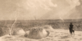
At the end of June, Mitchell decided to leave the Murray and explore the lands to the southwest. He was very impressed with this beautiful country and named it Australia Felix, meaning "Fortunate Australia." They crossed the Loddon River and reached the Grampians and the Wimmera River. They were guided by a local Aboriginal woman along the Glenelg River. Mitchell built a fortified base called Fort O'Hare. From there, he explored the Glenelg River to where it met the ocean at Discovery Bay.
When they reached Portland Bay on 29 August, Mitchell was surprised to find a farm and whaling station already set up by the Henty brothers. The expedition continued northeast. Mitchell observed Aboriginal communities who grew and harvested murnong plants using special tools.
On 17 September, to speed up his return, Mitchell split the party. The young girl Ballandella went with Mitchell, while her mother Turandurey stayed with the other group. On 30 September, Mitchell climbed and named Mount Macedon, from where he could see Port Phillip. They finally returned to British settlements on the Murrumbidgee on 24 October.
Inquiry
When Mitchell arrived in Sydney, he was celebrated. However, rumors spread about the incident at Mount Dispersion. He faced an official inquiry in December 1836 and received a formal warning. Ballandella lived with Mitchell's family and learned to read and write. She later married and had a family.
Fourth Expedition: Searching for a Northern River
Mitchell's fourth expedition was into the northern interior of the colony (now part of Queensland) in 1845–46. He believed a large river flowed northwest into the Gulf of Carpentaria, and finding it was his main goal.
On 15 December 1845, Mitchell started with a large group of 32 people, including Edmund Kennedy as his second-in-command. The Wiradjuri man Piper from his previous expedition, and another Wiradjuri man named Yuranigh, were also part of the group. They traveled north along the Bogan and Macquarie River. Mitchell noted areas where local Aboriginal people had resisted British expansion.

Near the Macquarie Marshes, Mitchell observed Aboriginal people harvesting native millet to make bread. Local guides led the group to the Barwon River and then to vital waterholes near the Narran River. Mitchell was concerned that "white man's cattle would soon trample these holes into a quagmire of mud." More harvested millet was seen along their journey up the Narran.
Following advice, they traveled north along the Balonne and Culgoa rivers. On 12 April 1846, Mitchell found a natural bridge of rocks on the Balonne, which he named St. George Bridge, now the site of St George. Mitchell pushed ahead with a few men, following the Balonne to the Maranoa and Cogoon (now Muckadilla Creek). He found an area with good pasture and a unique bottle tree hill, which he named Mount Abundance.
Mitchell continued exploring, sighting the headwaters of the Warrego and Nogoa Rivers. He then found the upper reaches of the Belyando River. He was disappointed to learn that this river was a tributary of the Burdekin River, which had already been explored by Ludwig Leichhardt.
He then turned west and found a river he was sure flowed northwest to the Gulf of Carpentaria. He followed it until he found a large group of Aboriginal people living in permanent huts. He named this place Yuranigh Pond after his guide and decided to return home. He named the river Victoria River, in honor of the British Queen. On the way back, Mitchell noticed the Mitchell grass. They arrived back in Sydney on 20 January 1847.
Later in 1847, Edmund Kennedy proved that the Victoria River did not flow northwest but turned southwest and joined Cooper Creek. He renamed it the Barcoo River.
Later Career and Legacy

In 1837, Mitchell took leave from his job and went to London. There, he published a book about his explorations called Three Expeditions into the Interior of Eastern Australia. He returned to Australia in 1841. He took another leave in 1847 and published Journal of an Expedition into the Interior of Tropical Australia.
Mitchell's journals are very important because they contain his detailed observations of the Aboriginal peoples he met. These books made him a famous Australian explorer. However, Mitchell was known for being a difficult person to work with.
In 1844, Mitchell was elected to the New South Wales Legislative Council. But he found it hard to be both a government employee and an elected member, so he resigned after only five months.
Duel
Mitchell is also remembered for being involved in the last known duel in Australia. In September 1851, he challenged Sir Stuart Alexander Donaldson to a duel. Donaldson had publicly criticized Mitchell's department for spending too much money. The duel happened in Sydney on 27 September. Both men missed their shots, and only Donaldson's hat was damaged. The pistols used in the duel are now in the National Museum of Australia.
Ophir Gold Fields
In 1851, Mitchell was asked to report on the goldfield discovered in the County of Bathurst. He traveled west to visit the Ophir gold diggings. In June 1851, Mitchell chose the site for the town of Ophir and planned its streets. He returned with gold specimens, and his report was presented in February 1852.
"Boomerang" Propeller
Mitchell was also interested in inventing. He developed a new type of ship propeller, which he called the "bomerang" propeller. The first test was in Sydney Harbour in May 1852. The propeller was fitted to a ship called Keera, and the tests were successful. Mitchell took his invention to England, where it was tested on other ships. The "boomerang" propeller was more efficient than other propellers at the time.
Family Life
Carthona-999.jpg)
Thomas Mitchell and his wife Mary had twelve children. Sadly, some of them died young. His son Roderick became a Commissioner of Crown Lands. His youngest daughter, Blanche, kept diaries about her daily life.
In 1841, Mitchell finished building his new home, Carthona, in Darling Point, Sydney. After Mitchell's death, his family moved to Woolloomooloo.
Death

In July 1855, an official inquiry was set up to look into the New South Wales Survey Department. However, Mitchell became ill while surveying a road and developed a severe chest infection. He died a few days later at his home, Carthona, on 5 October 1855. Newspapers at the time praised his long and difficult service to the colony, saying his name would be honored among Australia's early explorers. He is buried at Camperdown Cemetery in Newtown.
Places Named by Mitchell
Some of the places Mitchell named during his expeditions include:
- The Avoca River
- Balonne River
- Belyando River
- Campaspe River
- Cogoon River
- Discovery Bay
- Glenelg River
- Grampians
- Maranoa River
- Mount Arapiles
- Mount King
- Mount Macedon
- Mount Napier
- Mount William
- Nyngan
- Pyramid Hill
- St George
- Swan Hill
- Wimmera River
Commemoration

Many places and things across Australia are named after Sir Thomas Mitchell to remember his important contributions to surveying and exploring. These include:
- The town of Mitchell in Queensland
- The Mitchell River in Queensland
- The Canberra suburb of Mitchell
- The political area of Mitchell
- The Mitchell Highway
- The Major Mitchell's cockatoo, a type of cockatoo bird
- Mitchellstown in Victoria
- A local government area in Victoria, Shire of Mitchell
- A steam locomotive, S 301 Sir Thomas Mitchell
- Mitchell grass, a common type of grass found in dry areas of Australia
- Mitchell's hopping mouse, a native Australian animal
- Many roadside memorials in Victoria mark places where "Major Mitchell passed here."
- Sir Thomas Mitchell Road in Villawood, NSW
- Sir Thomas Mitchell Road in Bondi, NSW
- Sir Thomas Mitchell Drive in Bowenfels (Lithgow)
The highest honor in the New South Wales Surveyors Awards is the Sir Thomas Mitchell Excellence in Surveying Award.
A map of Mitchell's 1848 expedition was featured in a special exhibition celebrating Queensland's 150th anniversary.
Images for kids
-
Portrait of Major Sir Thomas Mitchell (c. 1830s)
-
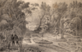
Aboriginal tomb site near Menindee Lakes
-
Indigenous burial ground at Milmeridien near Nyngan
-
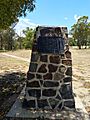
Centenary memorial erected in 1946 at Mitchell, Queensland to commemorate explorer Thomas Mitchell's naming of the nearby Maranoa River.
-
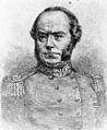
Engraving of Major Sir Thomas Mitchell
-
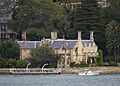
Carthona, Mitchell's home in Darling Point
-
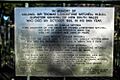
Thomas Mitchell Plaque, Camperdown
-
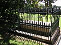
The grave of Major Mitchell, Surveyor General
See also
 In Spanish: Thomas Livingstone Mitchell para niños
