Wimmera River facts for kids
Quick facts for kids Wimmera |
|
|---|---|

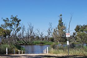
The Wimmera River at Jeparit
|
|
| Native name | Walla-walla, Wamara, Bunnut, Culcatok, Barbarton, Billiwhin, Wudjum-biat, Bar, Barengi-djul, Yaigir, Wudiyedi, Barrh, Tarnorrer, Barkar, Guri-beb, Giridji-gal, Wadidirabul, Maripmunninnera |
| Country | Australia |
| State | Victoria |
| Region | Murray Darling Depression (IBRA), Wimmera |
| Local government areas | Ararat, Northern Grampians, Yarriambiack, Horsham, Hindmarsh |
| Towns | Elmhurst, Crowlands, Glenorchy, Horsham, Dimboola, Tarranyurk, Jeparit |
| Physical characteristics | |
| Main source | Pyrenees, Great Dividing Range below Ben Nevis, in a state forestry area south of Elmhurst 299 m (981 ft) 37°16′29″S 143°15′00″E / 37.27472°S 143.25000°E |
| River mouth | Lake Hindmarsh, Lake Albacutya Outlook Creek, near Jeparit 79 m (259 ft) 36°06′42″S 141°56′51″E / 36.11167°S 141.94750°E |
| Length | 278 km (173 mi) |
| Basin features | |
| River system | Wimmera catchment |
| Basin size | 24,011 km2 (9,271 sq mi) |
| Tributaries |
|
| National parks | Wyperfeld National Park, Little Desert National Park |
The Wimmera River is a special river in Victoria, Australia. It's an inland river, meaning it doesn't flow directly into the ocean. Instead, it's part of the Wimmera region's water system.
The river starts in the Pyrenees mountains. These mountains are part of the larger Great Dividing Range. The Wimmera River flows mostly north and west. It ends up in a series of lakes like Lake Hindmarsh and Lake Albacutya. These lakes don't always have water in them; they can be dry sometimes. Even though the river doesn't reach the ocean, its water eventually connects to the Murray River system. This larger system is called the Murray-Darling Basin.
Contents
Journey of the Wimmera River
The Wimmera River begins its journey in the Great Dividing Range. This is near a town called Elmhurst. From there, it flows through several towns. These include Glenorchy, Horsham, Dimboola, and Jeparit. The river also forms the eastern edge of the Little Desert National Park.
Along its way, the Wimmera River is joined by 14 smaller streams. One important stream is the Mackenzie River. The Wimmera River travels about 278 kilometers (173 miles). During this journey, it drops about 220 meters (722 feet) in height.
River Flow and Lakes
The Wimmera River doesn't always reach its final lakes. Most years, the water flow isn't strong enough. When this happens, the river shrinks into separate pools of water. Lake Hindmarsh, where the river ends, only overflows about once every 20 years. When it does overflow, the water flows into Lake Albacutya.
Recently, the water quality in the lower parts of the river has become a problem. Salty water from underground has been flowing into the river. This has made some parts of the river even saltier than the ocean!
River Crossings
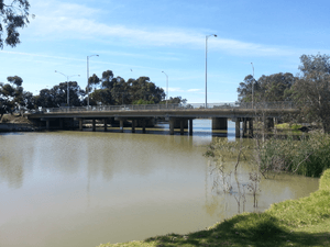
Many roads cross the Wimmera River. Near where it starts, the Pyrenees Highway crosses it. The Henty Highway crosses south of Horsham. The Western Highway crosses the river twice. Once west of Horsham and again west of Dimboola.
Unique River Branches
The Wimmera River has a special feature. It has branches that take water away from the main river. These are called distributaries. The Dunmunkle Creek and the Yarriambiack Creek are examples. They help to spread water out, especially when the river is very full or flooding.
Water Pipeline Project
The Wimmera River's health was expected to get better after a big project. This was the Wimmera-Mallee pipeline project, finished in 2008. The project replaced old water pipes that wasted a lot of water. These old systems lost up to 90% of the water through evaporation and leaks.
The new pipeline system is much more efficient. This means less water needs to be taken from the Wimmera River. This helps more water stay in the river itself. It's good for the environment and the river's ecosystem.
Flooding in Horsham
The Wimmera River near Horsham has flooded many times. Here are some of the biggest floods recorded:
| Flood Peak | Location(s) Affected | Notes | ||
|---|---|---|---|---|
| Meters | Feet | Date | ||
| 4.71 | 15.5 | January 2011 | Horsham area | This was a very high flood. |
| 3.87 | 12.7 | October 1894 | Dunmunkle and Yarriambiack creeks. Towns like Horsham, Glenorchy, Rupanyup, Warracknabeal, Dimboola, and Jeparit were affected. | A significant flood impacting many towns. |
| 3.87 | 12.7 | August 1909 | Dunmunkle and Yarriambiack creeks. Towns like Horsham, Glenorchy, Rupanyup, Warracknabeal, Dimboola, and Jeparit were affected. | Another large flood, similar to 1894. |
| 3.73 | 12.2 | September 1916 | Towns of Glenorchy and Horsham affected. | Flooding impacted these two towns. |
| 3.55 | 11.6 | August 1981 | Wimmera River and Yarriambiack Creek. | This flood affected both the main river and a key distributary. |
| 3.49 | 11.5 | October 1996 | Horsham area | Another notable flood event. |
| 3.32 | 10.9 | September 2010 | Horsham area | A more recent flood. |
| 3.30 | 10.8 | October 1992 | Horsham area | This flood also impacted the area. |
River Names and History
The Wimmera River has many names from the local Indigenous people. For example, in the Djadjawurrung language, it's called Walla-walla. In the Jardwadjali language, it's known as Wamara, which might mean "woomera" (a spear-thrower).
Other Indigenous names for the river include Bunnut, Barbarton, and Billiwhin. The name Barbarton includes "bar," which means "river." The Wergaia people had several names, like Wudjum-bial, where "bial" means "red gum tree." They also called it Barengi-djul, meaning "river waterbags."
The name "Wimmera" for the river comes from the name of a large farming area. Gold was found in the river in 1866, which brought more people to the area.
 | DeHart Hubbard |
 | Wilma Rudolph |
 | Jesse Owens |
 | Jackie Joyner-Kersee |
 | Major Taylor |


