Rural City of Horsham facts for kids
Quick facts for kids Rural City y of HorshamVictoria |
|||||||||||||||
|---|---|---|---|---|---|---|---|---|---|---|---|---|---|---|---|

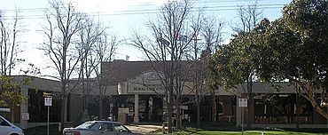
Municipal offices in Horsham
|
|||||||||||||||

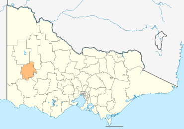
Location in Victoria
|
|||||||||||||||
| Population | 19,875 (2018) | ||||||||||||||
| • Density | 4.6578/km2 (12.064/sq mi) | ||||||||||||||
| Established | 1995 | ||||||||||||||
| Gazetted | 20 January 1995 | ||||||||||||||
| Area | 4,267 km2 (1,647.5 sq mi) | ||||||||||||||
| Mayor | Cr Robyn Gulline | ||||||||||||||
| Council seat | Horsham | ||||||||||||||
| Region | Grampians | ||||||||||||||
| State electorate(s) | Lowan | ||||||||||||||
| Federal Division(s) | Mallee | ||||||||||||||
 |
|||||||||||||||
| Website | Rural City y of Horsham | ||||||||||||||
|
|||||||||||||||
The Rural City of Horsham is a special area in Victoria, Australia. It's like a big local community that helps manage services for people living there. This area is located in the western part of Victoria. It covers a large space of about 4,267 square kilometers. In June 2018, around 19,875 people lived here.
The Rural City of Horsham includes several towns. These towns are Brimpaen, Dadswells Bridge, Dooen, Haven, Horsham, Laharum, Natimuk, Noradjuha, and Pimpinio.
This local government area was created in 1995. It was formed by joining together several older areas. These included the City of Horsham, most of the Shire of Wimmera, most of the Shire of Arapiles, and a part of the Shire of Kowree.
The Horsham Rural City Council runs and manages the Rural City. Their main office is in Horsham. Horsham is also the biggest town in the area. It has about 16,514 people living there.
Horsham was even named Australia's tidiest town in 2001! It has a great shopping area with coffee shops and restaurants. Horsham is a central hub for the region. It hosts many events, from sports to cultural activities. The Horsham golf course is considered one of the best in country Victoria. The region also has beautiful lakes and a river system called the Wimmera River. When the weather is good, these places are popular for fishing, boating, swimming, and other water fun.
Contents
Traditional Owners of the Land
The land that makes up the Rural City of Horsham has a long history. It is the traditional home of several Aboriginal groups. These groups are the Jaadwa, Jadawadjali, Jupagulk, Wergaia, and Wotjobaluk people. They have cared for this land for thousands of years.
How the City is Governed
Your Local Council Members
The Horsham Rural City Council is made up of seven councillors. These councillors are chosen by the people who live in the area. They work together to make decisions for the community. Here are the current councillors elected in 2020:
| Ward | Party | Councillor | Notes | |
|---|---|---|---|---|
| Unsubdivided | Independent | Penny Flynn | ||
| Independent | Di Bell | |||
| Independent | Robyn Gulline | |||
| Independent | Leslie Power | |||
| Independent | Ian Ross | |||
| Independent | Claudia Haenel | |||
| Independent | David Bowe | |||
Council Meetings and Offices
The council members hold their meetings at the Horsham Civic Centre. This is also where the council's main offices are located. You can visit these offices in Horsham if you need help or information from the council.
Towns and Localities
The Rural City of Horsham is home to many different towns and smaller areas. In 2021, the total population of the rural city was 20,429 people. This was a bit more than the 19,642 people counted in 2016.
Here is a list of the towns and localities in the area, along with their populations from recent years:
| Population | ||
|---|---|---|
| Locality | 2016 | 2021 |
| Arapiles | * | # |
| Blackheath | * | # |
| Brimpaen^ | 79 | 80 |
| Bungalally | 95 | 93 |
| Clear Lake | 78 | 57 |
| Dadswells Bridge^ | 71 | 69 |
| Dooen | 240 | 250 |
| Douglas^ | 65 | 74 |
| Drung | 147 | 119 |
| Duchembegarra | 38 | 47 |
| Population | ||
|---|---|---|
| Locality | 2016 | 2021 |
| Grass Flat^ | * | # |
| Haven | 1,304 | 1,443 |
| Horsham | 14,543 | 15,134 |
| Jilpander | * | # |
| Jung^ | 241 | # |
| Kalkee | 52 | 48 |
| Kanagulk | 18 | 28 |
| Kewell^ | 48 | 57 |
| Laharum^ | 196 | 162 |
| Longerenong^ | * | 237 |
| Population | ||
|---|---|---|
| Locality | 2016 | 2021 |
| Lower Norton | 231 | 236 |
| McKenzie Creek | 136 | 140 |
| Mitre^ | 69 | 66 |
| Mockinya | 33 | 30 |
| Murra Warra^ | 72 | 63 |
| Natimuk | 514 | 548 |
| Noradjuha | 83 | 89 |
| Nurrabiel | 61 | 43 |
| Pimpinio | 184 | 191 |
| Quantong | 310 | 354 |
| Population | ||
|---|---|---|
| Locality | 2016 | 2021 |
| Riverside | 276 | 287 |
| St Helens Plains | 42 | 40 |
| Telangatuk East | 65 | 75 |
| Tooan | 19 | 23 |
| Toolondo | 59 | 74 |
| Vectis | 179 | 184 |
| Wail | 42 | 44 |
| Wartook^ | 84 | 88 |
| Wonwondah | 103 | 114 |
^ - This area is split with another LGA
* - Population not recorded in the 2016 Census
# - Population not recorded in the 2021 Census
 | Toni Morrison |
 | Barack Obama |
 | Martin Luther King Jr. |
 | Ralph Bunche |

