
Nyngan facts for kids
Quick facts for kids NynganNew South Wales |
|||||||||
|---|---|---|---|---|---|---|---|---|---|

Court house, Nyngan
|
|||||||||

Nyngan
Location in New South Wales
|
|||||||||
| Population | 1,953 (2021 census) | ||||||||
| Postcode(s) | 2825 | ||||||||
| Elevation | 173 m (568 ft) | ||||||||
| Location |
|
||||||||
| LGA(s) | Bogan Shire | ||||||||
| County | Oxley | ||||||||
| State electorate(s) | Barwon | ||||||||
| Federal Division(s) | Parkes | ||||||||
|
|||||||||
Nyngan is a town located in the middle of New South Wales, Australia. It's part of the Bogan Shire local government area. In 2016, about 1,988 people lived there.
Nyngan sits on the Bogan River, between the towns of Narromine and Bourke. It's also where two major roads meet: the Mitchell Highway and the Barrier Highway. Nyngan is about 576 kilometres (358 miles) north-west of Sydney. The Barrier Highway starts here and goes west towards Cobar and Broken Hill.
A small airport, Nyngan Airport, is just north of the town. Nyngan is also on the Main Western railway line. While passenger trains don't stop here anymore, the railway is still used for moving goods. About 70 kilometres (43 miles) south of Nyngan, there's a special stone monument. It was put up in 1988 to mark the exact centre of New South Wales.
Contents
A Glimpse into Nyngan's Past
The land around Nyngan was originally home to the Wangaibon people. In 1835, an explorer named Thomas Mitchell explored the Bogan River. He camped right where Nyngan is today. Mitchell wrote down the local Aboriginal word nyingan. This word is thought to mean 'long pond of water', but it could also mean mussel or crayfish. Even before Mitchell returned from his journey, settlers had already started to move into the area. The town really grew after the railway line was finished in 1883.
How Nyngan Grew: The Story of Canonba
A small town called Canonba, about 25 kilometres (16 miles) north-east of Nyngan, played a big part in Nyngan's history. From the 1840s to the 1880s, Canonba was a busy place. It served nearby farms and was a stop for Cobb and Co. coaches. In the early 1880s, Canonba had several hotels, banks, shops, a police station, and churches.
However, when the Western Railway was built, it bypassed Canonba and went through Nyngan instead. Because of this, many people, businesses, and public services from Canonba moved to Nyngan. By 1890, Canonba was almost empty. Nyngan officially became a municipality (a town with its own local government) on February 17, 1891. At that time, Nyngan had a population of 1,355 people.
The Great Nyngan Flood of 1990
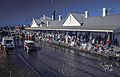
In April 1990, Nyngan faced a huge challenge. Very heavy rains caused major flooding in the town. Local people worked hard to build up the levee walls with sandbags, but the water was too much. The town became almost completely flooded. Everyone living in Nyngan had to be evacuated by helicopter. They were taken from the railway station, which was the highest point and stayed above the water.
Helicopters from the Air Force, TV news crews, and private owners all helped with the airlift. This amazing effort helped save everyone. The total damage from the flood was about $50 million. Today, an Army helicopter is displayed outside the Nyngan Railway Station. It reminds everyone of the incredible airlift during the 1990 floods. The railway station now has a museum, which includes exhibits about this historic flood.
Nyngan's Weather
Nyngan has a hot semi-arid climate. This means it has long, very hot summers and short, cool winters. Most of its rain falls in summer, often from strong thunderstorms. The temperatures can change a lot between seasons, both for the highest and lowest temperatures.
| Climate data for Nyngan Airport (31º33'S, 147º12'E, 173 m AMSL) (1920−2024, rainfall 1879−2024) | |||||||||||||
|---|---|---|---|---|---|---|---|---|---|---|---|---|---|
| Month | Jan | Feb | Mar | Apr | May | Jun | Jul | Aug | Sep | Oct | Nov | Dec | Year |
| Record high °C (°F) | 47.0 (116.6) |
47.4 (117.3) |
42.2 (108.0) |
38.9 (102.0) |
31.0 (87.8) |
27.2 (81.0) |
27.3 (81.1) |
31.8 (89.2) |
37.5 (99.5) |
41.1 (106.0) |
45.0 (113.0) |
46.0 (114.8) |
47.4 (117.3) |
| Mean daily maximum °C (°F) | 34.4 (93.9) |
33.4 (92.1) |
30.5 (86.9) |
25.7 (78.3) |
20.7 (69.3) |
17.0 (62.6) |
16.5 (61.7) |
18.6 (65.5) |
22.7 (72.9) |
26.6 (79.9) |
30.1 (86.2) |
33.0 (91.4) |
25.8 (78.4) |
| Mean daily minimum °C (°F) | 19.7 (67.5) |
19.3 (66.7) |
16.5 (61.7) |
12.0 (53.6) |
7.8 (46.0) |
5.0 (41.0) |
3.8 (38.8) |
4.8 (40.6) |
7.8 (46.0) |
11.5 (52.7) |
15.1 (59.2) |
17.9 (64.2) |
11.8 (53.2) |
| Record low °C (°F) | 8.4 (47.1) |
9.4 (48.9) |
6.4 (43.5) |
1.7 (35.1) |
−1.7 (28.9) |
−3.9 (25.0) |
−4.0 (24.8) |
−1.8 (28.8) |
−0.5 (31.1) |
1.7 (35.1) |
4.4 (39.9) |
7.8 (46.0) |
−4.0 (24.8) |
| Average rainfall mm (inches) | 51.1 (2.01) |
46.7 (1.84) |
41.9 (1.65) |
34.2 (1.35) |
35.6 (1.40) |
33.7 (1.33) |
28.8 (1.13) |
29.3 (1.15) |
27.4 (1.08) |
34.0 (1.34) |
36.8 (1.45) |
43.0 (1.69) |
442.2 (17.41) |
| Average rainy days (≥ 1.0 mm) | 3.9 | 3.4 | 3.5 | 2.8 | 3.5 | 4.0 | 3.8 | 3.8 | 3.4 | 3.9 | 3.9 | 3.8 | 43.7 |
| Average afternoon relative humidity (%) | 31 | 36 | 37 | 40 | 49 | 55 | 52 | 44 | 38 | 34 | 30 | 29 | 40 |
| Average dew point °C (°F) | 12.8 (55.0) |
13.1 (55.6) |
11.0 (51.8) |
9.4 (48.9) |
7.9 (46.2) |
6.9 (44.4) |
5.4 (41.7) |
4.4 (39.9) |
5.5 (41.9) |
6.4 (43.5) |
8.2 (46.8) |
9.8 (49.6) |
8.4 (47.1) |
| Source: Bureau of Meteorology (1920–2024 normals and extremes, rainfall 1879-2024) | |||||||||||||
| Historical population | ||
|---|---|---|
| Year | Pop. | ±% |
| 1921 | 1,374 | — |
| 1933 | 1,545 | +12.4% |
| 1947 | 1,802 | +16.6% |
| 1954 | 2,257 | +25.2% |
| 1961 | 2,414 | +7.0% |
| 1966 | 2,591 | +7.3% |
| 1971 | 2,487 | −4.0% |
| 1976 | 2,359 | −5.1% |
| 1981 | 2,485 | +5.3% |
| 1986 | 2,502 | +0.7% |
| 1991 | 2,311 | −7.6% |
| 1996 | 2,240 | −3.1% |
| 2001 | 2,065 | −7.8% |
| 2006 | 1,975 | −4.4% |
| 2011 | 2,073 | +5.0% |
| 2016 | 1,988 | −4.1% |
| 2021 | 1,761 | −11.4% |
| Source: Australian Bureau of Statistics data. | ||
Special Places in Nyngan
Nyngan has some places that are listed for their historical importance. These are called heritage-listed sites:
- Cemetery Road: Chinese Graves and Burner at Nyngan Cemetery
- 77–79 Cobar Street: Nyngan Court House
Harnessing the Sun's Power: Nyngan's Solar Plant
About 10 kilometres (6 miles) west of Nyngan, you'll find one of Australia's biggest solar power stations. It has an amazing 1.36 million solar panels! When it opened in July 2016, it was the largest solar PV (photovoltaic) plant in Australia. This plant works together with another one in Broken Hill. Together, they can produce a lot of clean energy.
Local Media
Nyngan has its own radio station called Outback Radio 2WEB. You can listen to it on 100.7 MHz.
Images for kids
-
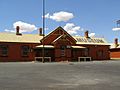
Railway station (now museum), Nyngan
-
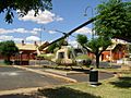
Helicopter commemorating the airlift during the 1990 floods
-
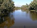
The Bogan River at Nyngan
-
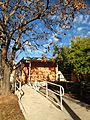
Bogan Shire Library, 73 Cobar Street Nyngan, New South Wales
-
Nyngan railway station during the 1990 evacuation


