
Charleville, Queensland facts for kids
Quick facts for kids CharlevilleQueensland |
|||||||||||||||
|---|---|---|---|---|---|---|---|---|---|---|---|---|---|---|---|

The Royal Flying Doctor Service visitor centre at Charleville
|
|||||||||||||||

Charleville
Location in Queensland
|
|||||||||||||||
| Population | 2,992 (2021 census) | ||||||||||||||
| • Density | 4.8769/km2 (12.631/sq mi) | ||||||||||||||
| Established | 1865 | ||||||||||||||
| Postcode(s) | 4470 | ||||||||||||||
| Elevation | 293.5 m (963 ft) | ||||||||||||||
| Area | 613.5 km2 (236.9 sq mi) | ||||||||||||||
| Time zone | AEST (UTC+10:00) | ||||||||||||||
| Location |
|
||||||||||||||
| LGA(s) | Shire of Murweh | ||||||||||||||
| State electorate(s) | Warrego | ||||||||||||||
| Federal Division(s) | Maranoa | ||||||||||||||
|
|||||||||||||||
|
|||||||||||||||
Charleville (/ˈtʃɑːrlvɪl/) is a country town and area in Queensland, Australia. It is found in the Shire of Murweh. In 2021, Charleville had a population of 2,992 people.
Contents
- Exploring Charleville's Location
- Charleville's Past: A Journey Through Time
- Who Lives in Charleville?
- Places of Interest in Charleville
- Learning in Charleville
- What to Do in Charleville
- Fun Things to See and Do
- Getting Around Charleville
- Charleville's Weather
- Famous People from Charleville
- Images for kids
Exploring Charleville's Location
Charleville is in southwestern Queensland, Australia. It is the end point for the Warrego Highway. This highway stretches 747 kilometres (464 miles) from Brisbane.
Charleville is also connected by the Mitchell Highway to other towns:
- Augathella – 84 kilometres (52 miles) north
- Cunnamulla – 200 kilometres (120 miles) south
- Sydney – 1,212 kilometres (753 miles) south-east
It is the biggest town and main centre for the Shire of Murweh. This area covers 43,905 square kilometres. Charleville sits on the banks of the Warrego River.
Charleville's Past: A Journey Through Time

The land where Charleville now stands was originally home to the Kunja people. The first European to explore this area was Edmund Kennedy in 1847.
Two important Aboriginal languages of this region are Bidjara and Gungabula. These languages are spoken by the Bidjara and Gungabula peoples. Their traditional lands include areas around Charleville.
How Charleville Began
The town of Charleville was officially named on January 11, 1865. It was built near a permanent waterhole called Gowrie's Crossing. This spot was important for sheep and cattle grazing. The streets were made very wide. This was so that large bullock teams could easily turn their wagons.
William Alcock Tully planned the town's streets. He was an Irishman and likely named the town after Charleville in County Cork, Ireland.
An early hotel was built in 1865. The Charleville Post Office opened in August 1865. Soon, a town grew to serve the people in the area. A store called Warrego Stores opened in 1872.
In 1875, a courthouse was built. The first hospital in Charleville was completed around 1885.


The Arrival of Transport and Technology
Cobb and Co, a famous Australian stagecoach company, started building coaches in Charleville in 1886. However, the railway arrived in 1888. This slowly led to the end of coach travel in the area.
The Charleville railway station opened on March 1, 1888. It was the end of the Western railway line for a while. The station had places for trains, cattle yards, and offices. Today, the Charleville railway station is used by Queensland Rail. It is also a stop for Greyhound Australia buses.
In 1902, Clement Lindley Wragge tried to make it rain in Charleville. He used cannons to fire into the clouds to break a drought. These cannons are still on display in Charleville today.
In 1922, Qantas started its first regular airmail service. It flew between Charleville and Cloncurry. This was only the second planned air route in Australia.
Charleville was also a required stop during the London to Melbourne MacRobertson Air Race in 1934. The winners, Tom Campbell Black and C. W. A. Scott, flew into Charleville. They refueled and then continued to Melbourne. They finished the race in just under three days!
Dealing with Floods
Being close to the Warrego River has caused problems. Charleville has been hit by floods many times. Major floods happened in 1971 and April 1990. In 1990, the floodwaters were very high. Over 1,000 homes were flooded, and almost 3,000 people had to leave their homes. More floods happened in 1997, 2008, 2010, and 2012.
To protect the town, a levee (a wall to hold back water) was built. It was finished in 2009. This levee helped protect the town during the 2012 floods. In 2013, another system was built to protect the town from flooding in Bradley’s Gully.
Who Lives in Charleville?
In 2016, Charleville had 3,335 people. About 15.3% of the people were Aboriginal and Torres Strait Islander. Most people (83.6%) were born in Australia. The next most common country of birth was Vietnam (3.3%).
Most people (87.6%) spoke only English at home. Other languages included Vietnamese (3.5%). The most common religions were Catholic (34.1%), Anglican (24.1%), and No Religion (17.2%).
In 2021, the population of Charleville was 2,992 people.
Places of Interest in Charleville
Charleville has several places that are important for their history. These are called heritage-listed sites:
- Former Queensland National Bank at 87 Alfred Street
- Charleville War Memorial on Edward Street
- Charleville railway station on King Street
- Hotel Corones at 33 Wills Street
Learning in Charleville
Charleville has several schools for students of all ages.
Primary Schools
- Charleville State School is a government primary school for students from Early Childhood to Year 6. It is on Wills Street.
- St Mary's School is a Catholic primary school for students from Preparatory to Year 6. It is on Watson Street.
Both Charleville State School and St Mary's School were badly damaged during the 1990 floods.
Secondary Schools
- Charleville State High School is a government secondary school for students from Year 7 to Year 12. It is on Partridge and Hunter Streets. It opened in 1961. Students from nearby towns like Augathella and Morven also attend this school.
Distance Education
- Charleville School of Distance Education is a government school for students from Early Childhood to Year 10. It is on Parry Street. This is a School of the Air. It teaches children who live in remote areas. They learn through mail, phone, and the internet.
What to Do in Charleville
Charleville has many fun things for the community. These include a swimming pool, a bowling green, a speedway, and a racing course. There is also the Gowrie sporting oval.
The Murweh Shire Council runs a public library on Alfred Street. It has a fast internet connection.
The Charleville Golf Course has eighteen sand greens. The Charleville Bowls Club has two bowling rinks.
Places of Worship
- All Saints Anglican Church is at 41 Alfred Street.
- Lutheran church services are held at the Bluecare Community Centre at 145 Alfred Street.
Local Media
The local newspaper is the Western Times. It became an online-only publication in June 2020.
Charleville also has several radio stations:
- ABC Western Queensland – 603 AM
- 4VL – 918 AM
- Vision Christian Radio – 87.6 FM
- Hot FM - 87.8 FM
- West FM – 101.7 FM
- 4RR FM – 105.7 FM
- ABC Radio National – 107.3 FM
The Australian Broadcasting Corporation (ABC) also has a news bureau in Charleville.
Fun Things to See and Do
Charleville has many cool places for tourists to visit:
- Charleville Royal Flying Doctor Service of Australia Visitor Centre: Learn about the amazing Royal Flying Doctor Service.
- Charleville Historical Museum: Explore the town's history.
- Cosmos Centre: A great place for stargazing and learning about space.
- World War II Secret Base: Discover what the 3500 United States Army Air Force personnel did here in 1943.
- Charleville Bilby Experience: See the greater bilby, a special Australian animal. This centre helps protect them.
Getting Around Charleville

Airport
Charleville Airport is about 4 kilometres (2.5 mi) southwest of the town centre. It has two runways for planes.
Train Services
The The Westlander train service connects the Charleville railway station to Brisbane. This train started running in August 1954. Before 1994, the Westlander used to split at Charleville. One part went to Quilpie, and the other went to Cunnamulla. Now, passenger services only go as far as Charleville.
Bus Services
Since December 2021, Greyhound Australia has provided bus services to and from Charleville. They connect Charleville to many towns, including Brisbane, Toowoomba, Roma, Longreach, and Mount Isa.
| Preceding station | Queensland Rail | Following station | ||
|---|---|---|---|---|
| Morven
towards Brisbane
|
The Westlander | Terminus | ||
Charleville's Weather
Charleville has a hot semi-arid climate. This means it has hot summers with some rain and humidity. Winters are mild and dry, with occasional frost. The temperature can change a lot between day and night.
The average highest temperature in January is 35.2 °C (95.4 °F). In July, it's about 19.7 °C (67.5 °F). The town gets about 487.3 mm (19.19 in) of rain each year. Most of the rain falls in summer. Sometimes, big floods can happen because of tropical storms. The hottest temperature ever recorded was 47.0 °C (116.6 °F) in January 1947. The coldest was −5.2 °C (22.6 °F) in July 1951.
| Climate data for Charleville (26º24'36"S, 146º15'36"E, 302 m AMSL) (1942-2024 normals, extremes 1889-2024) | |||||||||||||
|---|---|---|---|---|---|---|---|---|---|---|---|---|---|
| Month | Jan | Feb | Mar | Apr | May | Jun | Jul | Aug | Sep | Oct | Nov | Dec | Year |
| Record high °C (°F) | 47.0 (116.6) |
45.2 (113.4) |
43.9 (111.0) |
38.8 (101.8) |
33.3 (91.9) |
31.0 (87.8) |
30.7 (87.3) |
35.8 (96.4) |
40.7 (105.3) |
43.2 (109.8) |
45.0 (113.0) |
46.0 (114.8) |
47.0 (116.6) |
| Mean daily maximum °C (°F) | 35.2 (95.4) |
34.0 (93.2) |
32.2 (90.0) |
28.3 (82.9) |
23.4 (74.1) |
20.0 (68.0) |
19.7 (67.5) |
22.1 (71.8) |
26.3 (79.3) |
30.0 (86.0) |
32.9 (91.2) |
34.9 (94.8) |
28.2 (82.8) |
| Mean daily minimum °C (°F) | 22.0 (71.6) |
21.4 (70.5) |
18.9 (66.0) |
13.9 (57.0) |
9.0 (48.2) |
5.6 (42.1) |
4.4 (39.9) |
5.9 (42.6) |
10.0 (50.0) |
14.6 (58.3) |
18.0 (64.4) |
20.5 (68.9) |
13.7 (56.6) |
| Record low °C (°F) | 10.6 (51.1) |
9.4 (48.9) |
5.0 (41.0) |
0.8 (33.4) |
−3.6 (25.5) |
−5.0 (23.0) |
−5.2 (22.6) |
−4.9 (23.2) |
−1.7 (28.9) |
0.9 (33.6) |
4.4 (39.9) |
6.7 (44.1) |
−5.2 (22.6) |
| Average precipitation mm (inches) | 74.7 (2.94) |
66.5 (2.62) |
59.8 (2.35) |
28.5 (1.12) |
29.8 (1.17) |
24.6 (0.97) |
24.3 (0.96) |
19.5 (0.77) |
24.4 (0.96) |
35.6 (1.40) |
44.7 (1.76) |
55.5 (2.19) |
487.3 (19.19) |
| Average precipitation days (≥ 1.0 mm) | 5.6 | 5.0 | 4.1 | 2.6 | 2.6 | 2.6 | 2.7 | 2.3 | 2.5 | 3.9 | 4.3 | 5.4 | 43.6 |
| Average afternoon relative humidity (%) | 30 | 34 | 31 | 32 | 36 | 39 | 35 | 29 | 24 | 23 | 23 | 25 | 30 |
| Average dew point °C (°F) | 11.1 (52.0) |
12.8 (55.0) |
10.1 (50.2) |
7.6 (45.7) |
5.7 (42.3) |
4.1 (39.4) |
2.0 (35.6) |
0.9 (33.6) |
1.2 (34.2) |
3.4 (38.1) |
5.3 (41.5) |
7.7 (45.9) |
6.0 (42.8) |
| Source: Bureau of Meteorology (1942-2024 normals, extremes 1889-2024) | |||||||||||||
Famous People from Charleville
Many talented people have come from Charleville, including:
- Davida Allen (born 1951), a painter, filmmaker, and writer.
- Daryl Beattie (born 1970), a former professional motorcycle racer.
- Cameron Boyce (born 1989), a first-class cricketer.
- Kurt Capewell (born 1993), a rugby league footballer who won a championship with the Penrith Panthers.
- Luke Capewell (born 1989), a former rugby league footballer.
- Matthew Mott (born 1973), a former cricketer and coach.
- Libby Munro (born 1981), an actress.
- Adrian Vowles (born 1971), a former rugby league footballer.
Images for kids
-
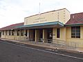
Railway station
-
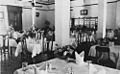
Dining room of the Hotel Corones
-
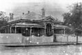
Queensland National Bank
-
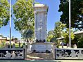
War memorial


