Warrego River facts for kids
Quick facts for kids Warrego |
|
|---|---|

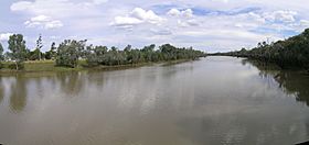
The Warrego River at Cunnamulla
|
|

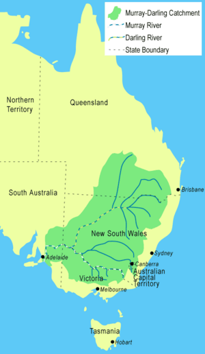
The Warrego River is the northernmost river located in the Murray–Darling basin
|
|
| Country | Australia |
| States | Queensland, New South Wales |
| Region | South West Queensland, Orana |
| Settlements | Augathella, Charleville, Wyandra, Cunnamulla |
| Physical characteristics | |
| Main source | Mount Ka Ka Mundi, Carnarvon Range east of Tambo, Queensland 625 m (2,051 ft) 25°03′22″S 147°28′49″E / 25.05611°S 147.48028°E |
| River mouth | Darling River near Bourke, New South Wales 98 m (322 ft) 30°24′13″S 145°20′54″E / 30.40361°S 145.34833°E |
| Length | 1,380 km (860 mi) |
| Depth |
|
| Basin features | |
| River system | Darling River catchment, Murray-Darling basin |
| Basin size | 69,290 km2 (26,750 sq mi) |
| Tributaries |
|
| Reservoirs | Dillalah Waterhole, Ten Mile Waterhole, Lower Lila Dam, Six Mile Dam, Turtle Waterhole, and Boera Dam |
The Warrego River is a river in Australia that doesn't always flow. It's part of the huge Murray–Darling basin, which is a very important river system. The Warrego River flows through the south-west of Queensland and the Orana region of New South Wales. It's the most northern river that joins the Darling River.
Contents
Where the Warrego River Flows
The Warrego River starts high up in the Carnarvon Range in Queensland, near a place called Tambo. From there, it flows south for about 1,380-kilometre (860 mi) until it meets the Darling River near Bourke.
Along its journey, many smaller rivers and creeks join the Warrego. These are called tributaries. Some of the main ones are the Nive River and the Langlo River. The river drops about 528 metres (1,732 ft) from its source to where it ends.
The Warrego River also flows through several important waterholes and dams. These include the Dillalah Waterhole, Ten Mile Waterhole, Lower Lila Dam, Six Mile Dam, Turtle Waterhole, and Boera Dam.
Several towns are located along the banks of the river. These include Augathella, Charleville, Wyandra, and Cunnamulla.
How the River Gets its Water
Most of the land around the Warrego River is quite dry. It gets between 350 and 500 millimetres (14 and 20 in) of rain each year, but this rainfall can be very unpredictable. The land is mostly covered with natural grasslands and saltbush plants.
Because the rainfall is so unreliable, the Warrego River is an ephemeral stream. This means it doesn't flow all the time. Sometimes, years can pass without any water flowing in the river! A lot of water only reaches the Darling River during very wet years. These wet periods are often linked to a weather pattern called La Niña.
How Water Spreads Out
South of Wyandra, the Warrego River splits into many smaller creeks and channels. These are sometimes called "anabranches." During floods, these channels help spread the water across the land.
For example, the Widgeegoara, Kudnapper, and Noorama Creeks can carry water into Nebine Creek, which then flows into the Culgoa River. Another channel, Cuttaburra Creek, connects the Warrego to the Paroo River through a system of channels and wetlands. The Irrara Creek also flows into Kerribree Creek, which then fills several wetlands, including Utah Lake.
Flooding in the Warrego River
When a La Niña event happens, it often brings a lot of rain, causing floods along the Warrego River. Big floods have happened in years like 1950, 1954 to 1956, 1971, 1973, 1998, and 2008.
One of the biggest floods ever recorded on the river happened in April 1990. This was unusual because it wasn't during a La Niña event. Instead, two very strong weather systems brought over 400 millimetres (16 in) of rain to Cunnamulla in just two weeks! That's more rain than the area usually gets in over half a year. The river reached very high levels, and the towns of Augathella and Charleville were badly affected. In Charleville, the river reached a peak height of 8.54 metres (28.0 ft).
Animals in the River Area
The Warrego River is home to several types of fish. It's one of the few rivers where silver perch naturally breed. You can also find golden perch and murray cod in its waters.
Near the river's source, there's a large area called Carnarvon Station. In 2001, the Australian Bush Heritage Fund bought this 590 square kilometres (230 sq mi) property. They set it aside to protect different types of birds and animals that are at risk.
What the Name "Warrego" Means
The name Warrego comes from the Aboriginal Bidyara language. It is thought to mean "bad" or "river of sand."
The name Warrego has also been used for other things. Two warships of the Royal Australian Navy were named HMAS Warrego after the river. The Warrego Highway, a major road, also gets its name from the river.
Cultural Heritage of the Warrego River Area
The land around the Warrego River has a rich Aboriginal history and culture.
- Bidjara language: This language is spoken by the Bidjara people. Their traditional lands include areas within the Murweh Shire Council, especially around the towns of Charleville, Augathella, and Blackall.
- Gunya language: This language is spoken by the Gunya people. Their traditional lands cover areas within the Paroo Shire Council, including Cunnamulla and stretching towards Augathella, Bollon, and Thargomindah.
 | Shirley Ann Jackson |
 | Garett Morgan |
 | J. Ernest Wilkins Jr. |
 | Elijah McCoy |

