
Wyandra, Queensland facts for kids
Quick facts for kids WyandraQueensland |
|||||||||||||||
|---|---|---|---|---|---|---|---|---|---|---|---|---|---|---|---|

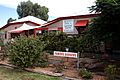
Wyandra General Store, 2009
|
|||||||||||||||

Wyandra
Location in Queensland
|
|||||||||||||||
| Population | 78 (2021 census) | ||||||||||||||
| • Density | 0.01539/km2 (0.0399/sq mi) | ||||||||||||||
| Postcode(s) | 4489 | ||||||||||||||
| Area | 5,069.5 km2 (1,957.3 sq mi) | ||||||||||||||
| Time zone | AEST (UTC+10:00) | ||||||||||||||
| Location |
|
||||||||||||||
| LGA(s) | Paroo Shire | ||||||||||||||
| State electorate(s) | Warrego | ||||||||||||||
| Federal Division(s) | Maranoa | ||||||||||||||
|
|||||||||||||||
Wyandra is a small country town in Queensland, Australia. It is located in the Shire of Paroo. In 2021, only 78 people lived there, making it a very quiet place.
Contents
Wyandra's Location and Landscape
Wyandra is a rural area with a beautiful natural setting. The Warrego River flows right through the town. This river runs from the north to the south. The main road, called the Mitchell Highway, also runs through the area. It stays close to the river.
The town of Wyandra is located in the middle of the area. It is just east of the river. It is also west of the highway. Wyandra is about 827 kilometers (514 miles) west of Brisbane. Brisbane is the capital city of Queensland. The town is also about 110 kilometers (68 miles) north of Cunnamulla.
The History of Wyandra
Wyandra has an interesting past, starting with early settlements.
Early Settlement and Name Change

British settlers first came to this area in 1861. Henry and Frederick Weaver started a large sheep farm. They called it Claverton Downs. It was located along the Warrego River. The Weavers were from Bath, England. They named their farm after a place near their hometown.
In the mid-1860s, a police station was set up. It was called the Claverton Native Police barracks. The name of the area changed to Wyandra in 1896.
Growth with the Railway
The town of Wyandra grew a lot in 1897. This happened when the Western railway line was finished. The railway came from Charleville. Wyandra quickly became an important place. It helped transport goods from nearby farms.
Education in Wyandra
The first school in Wyandra opened on February 10, 1898. It was called Wyandra Provisional School. It became a State School on January 1, 1909.
Remembering War Heroes
In February 1921, the people of Wyandra built a special memorial. It is located at the corner of Macks and Warrego Streets. This memorial honors local people who served in World War I. It has a statue of a soldier. The memorial lists 23 names of those who joined the military. It also remembers three people who died.
Powering the Town
A power station was built in Wyandra in 1955. Its generators came from Cunnamulla. Wyandra got connected to the state electricity system in 1970. The old power station is now a museum.
Community Facilities in Wyandra
Wyandra has several useful places for its residents.
Local Library
The Paroo Shire Council runs the Wyandra Library. You can find it on Macks Street. It's a great place to read and learn.
Museums and Parks
Wyandra is home to the Powerhouse Museum. This museum used to be the town's power station. The Wyandra hall has a park behind it. There are also public toilets in front of the hall. A free caravan park is located behind the school.
Education Opportunities
Wyandra has a primary school for young students.
Wyandra State School

Wyandra State School is a government primary school. It teaches children from Early Childhood to Year 6. The school is located on Moody Street. In 2017, there were 4 students enrolled. There was one teacher and two other staff members.
Secondary Education Options
There is no high school in Wyandra itself. Older students travel to nearby towns for secondary school. The closest high schools are about 125 kilometers (78 miles) away. These include Charleville State High School in Charleville. Another option is Cunnamulla P–12 State School in Cunnamulla.
Images for kids
-
Wyandra General Store, 2009
-
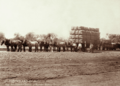
Wool bales from Claverton Station at Wyandra Railway Station, circa 1897
-

Wyandra State School, 2023
