Augathella facts for kids
Quick facts for kids AugathellaQueensland |
|||||||||||||||
|---|---|---|---|---|---|---|---|---|---|---|---|---|---|---|---|

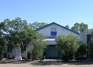
Memorial Hall, Augathella
|
|||||||||||||||
| Postcode(s) | 4477 | ||||||||||||||
| Area | 1,459.1 km2 (563.4 sq mi) | ||||||||||||||
| Time zone | AEST (UTC+10:00) | ||||||||||||||
| Location |
|
||||||||||||||
| LGA(s) | Shire of Murweh | ||||||||||||||
| State electorate(s) | Warrego | ||||||||||||||
| Federal Division(s) | Maranoa | ||||||||||||||
|
|||||||||||||||
Augathella is a small town and area in Queensland, Australia. It is located in the Shire of Murweh. In 2021, about 328 people lived in Augathella.
| Top - 0-9 A B C D E F G H I J K L M N O P Q R S T U V W X Y Z |
Discover Augathella: A Queensland Town
Augathella is located on the Matilda Highway. It is about 85 kilometers (53 miles) north of Charleville. The town sits on the banks of the Warrego River.
The main business in this area is still grazing. This means raising animals like cattle or sheep.
Augathella's Past: A Look at History
First Peoples: Aboriginal History
The land around Augathella has been home to Aboriginal people for a very long time. Several Aboriginal languages were spoken here.
- The Bidjara language was spoken by the Bidjara people. Their land included areas around Charleville, Augathella, and Blackall.
- The Gungabula language was spoken near the headwaters of the Dawson River. This area also included parts of Charleville, Augathella, and Blackall.
- The Gunya language was spoken by the Gunya people. Their traditional lands stretched from Cunnamulla north towards Augathella.
Early European Settlement
The first European explorer to visit this region was Edmund Kennedy in 1847. He met Aboriginal people who used the words "Yo, Yo." Kennedy named a nearby creek "Yo Yo Creek."
In 1862, pastoralists (people who raise livestock) began to settle here. James Norman set up large land leases for Joseph Fleming and Adeline Dollman. He started properties called Burenda, Yo Yo, and Augathella.
Aboriginal people resisted the new settlers. They had some victories against the Native Police. However, a Native Police station was built in 1864. This led to more control by the settlers.
How Augathella Town Grew
The town of Augathella grew slowly. It started as a resting place for bullock teams. These were teams of oxen used to pull heavy wagons. Three main tracks from Morven, Tambo, and Charleville met here.
The town was first called Burenda. Then it was renamed Ellangowan. In 1883, it was officially named Augathella. This name is believed to be an Indigenous Australian word. It means "camp on a waterhole," referring to the Warrego River.
- The Burenda Post Office opened in 1869. It changed its name to Ellangowan in 1877 and then to Augathella in 1883.
- Augathella Provisional School opened in 1884. It became Augathella State School in 1893.
- St Luke's Anglican Church opened in 1892. A new church building was completed in 1957.
- The Augathella Presbyterian Church opened in 1928.
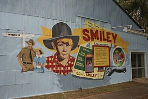
The 1956 movie Smiley was based on a book set in a fictional town like Augathella.
In the 1980s, the new Matilda Highway bypassed the town center. This meant less traffic went through the main street. However, some new businesses have since opened along the highway.
In April 1990, the Warrego River flooded. More than 50 houses in Augathella were covered by water.
The Augathella Library opened in 2000.
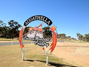
Since 2011, a large 4.5-meter (15-foot) steel and copper sculpture of a meat ant has stood in the main street. This sculpture honors the town's former junior football team, the "Mighty Meat Ants."
People in Augathella
In 2006, Augathella had 395 people. By 2016, the population grew to 449 people. In 2021, the population was 328 people.
Places of Interest
Augathella has several places listed for their historical importance. These are called heritage-listed sites.
Some of these sites in town include:
- The Catholic Church and School on Annie Street.
- The Hospital and Queensland Country Women's Association on Cavanagh Street.
- The Rodeo Grounds on Elmes Street.
- The Augathella Water Tower on Forest Street.
- The Kenniff Tree on Jane Street.
- The Arts and Craft Centre (old Helton's Building) on Main Street.
- The Butcher shop, Police station, Post office, and Town hall on Main Street.
- The War Memorial Hill on Main Street.
- The Ellangowan Hotel at Main and Annie Streets.
- St Luke's Anglican Church at 61 Main Street.
- The Old Water Tower on Nelson Street.
- The Cemetery off Russell Street.
- The Augathella Race Course off West Street.
Outside the town, other heritage sites include:
- Fig Tree Spring Stockyards at Carnarvon Station.
- Ralph's Bore & Upper Warrego Police Barracks site on Dooloogarah Carnarvon National Park Road.
- A section of the Dingo Fence at Mount Tabor.
Learning in Augathella
Augathella State School is a government primary school. It teaches students from early childhood up to Year 6. It is located on Cavanagh Street. In 2018, the school had 44 students.
There is no high school in Augathella. Older students (Year 7 to Year 12) take a school bus to Charleville. They attend Charleville State High School there.
Community Life and Activities
The Murweh Shire Council runs the Augathella Library on Main Street.
The Augathella branch of the Queensland Country Women's Association has its rooms on Cavanagh Street.
St Luke's Anglican Church is on Main Street. It holds services once a month.
The town also has a growing arts center, a public swimming pool, and a bowls club. Augathella also has polocrosse teams. Polocrosse is a team sport that combines polo and lacrosse.
Events in Augathella
Augathella holds an annual rodeo. There is also a Christmas Celebration held in Meat Ant Park every December.
Media and Communication
Augathella receives several radio and TV channels:
- Radio 4VL (Resonate Radio) on 106.1 FM.
- Australian Broadcasting Corporation (ABC) channels like ABC Television, ABC Kids, ABC TV Plus, ABC Me, and ABC News.
- Seven Network channels like ITQ, 7two, and 7mate.
- Nine Network channels like Imparja Television, 9Gem, and 9Go!.
- Network Ten channels like CDT, 10 Bold, and 10 Peach.
- Special Broadcasting Service (SBS) channels like SBS Viceland, SBS World Movies, and SBS Food.
Things to See
Augathella is home to the Q150 Shed. This shed traveled around Queensland in 2009 for the Q150 Celebrations. It brought entertainment to many communities.
Getting Around
Augathella is located where the Landsborough Highway and the Mitchell Highway meet.
- Greyhound Australia buses stop at the BP Roadhouse on the highway. They connect Augathella to places like Brisbane and Mount Isa.
- Augathella Aerodrome has a sealed runway. The Murweh Shire Council operates it.
See Also
- List of towns in Queensland
 | Misty Copeland |
 | Raven Wilkinson |
 | Debra Austin |
 | Aesha Ash |


