Glenelg River (Victoria) facts for kids
Quick facts for kids Glenelg |
|
|---|---|

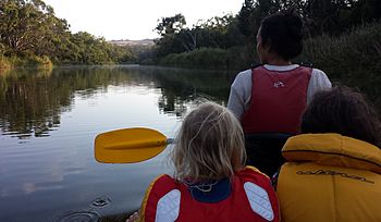
Family canoeing on the Glenelg River
|
|

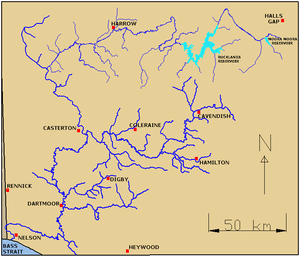
Map of Glenelg River catchment
|
|
| Native name | Bochara, Worrewurnin, Bugara, Temiangandgeen, Wurri-wurri, Barrawy, Barker, Wurru-wurru |
| Country | Australia |
| States | Victoria, South Australia |
| Region | Victorian Midlands, Naracoorte Coastal Plain (IBRA), Western Victoria, Limestone Coast, South Australia |
| Local government areas | Southern Grampians (V), West Wimmera (V), Glenelg (V), Grant (SA) |
| Settlements | Balmoral (V), Harrow (V), Casterton (V), Dartmoor (V), Donovans (SA), Nelson (V) |
| Physical characteristics | |
| Main source | Grampian Ranges Grampians National Park, Victoria 759 m (2,490 ft) 37°20′57″S 142°15′57″E / 37.34917°S 142.26583°E |
| River mouth | Discovery Bay, Great Australian Bight Nelson, Victoria 0 m (0 ft) 38°03′39″S 140°59′8″E / 38.06083°S 140.98556°E |
| Length | 350 km (220 mi) |
| Depth |
|
| Basin features | |
| River system | Glenelg Hopkins catchment |
| Basin size | 12,660 km2 (4,890 sq mi) |
| Tributaries |
|
| National parks | Grampians, Lower Glenelg |
The Glenelg River is a long river in Australia. It flows through the states of Victoria and South Australia. It's a perennial river, meaning it flows all year round.
The river starts in the Grampians National Park and travels for over 350 kilometres (220 mi) (about 217 miles). This makes it the longest river in southwest Victoria. It flows north, then west, then south. A small part of the river even goes into South Australia before coming back to Victoria. Finally, it empties into Discovery Bay at a town called Nelson. The Glenelg River is a very important part of the Lower Glenelg National Park.
The river was named in August 1836 by Major Thomas Mitchell. He named it after Baron Glenelg, Charles Grant, who was a Colonial Secretary. A lot of water from the upper part of the river is used for farming and for towns. The river's mouth, where it meets the sea, is a very important wetland area.
Contents
River's Journey and Features
The Glenelg River begins high up in the Grampians National Park. It starts at about 760 metres (2,490 ft) (2,493 feet) above sea level. It flows north through swamps, then west, and then south.
Rocklands Reservoir
A large reservoir called Rocklands Reservoir holds the river's water. This reservoir was built in 1953 and can hold a huge amount of water. After leaving the dam, the river flows west through forests.
River's Path and Tributaries
The Glenelg River then passes near towns like Balmoral and Harrow. Many smaller creeks join the Glenelg River along its path. These smaller rivers and creeks are called tributaries. Some important tributaries include the Chetwynd River, the Wannon River, the Stokes River, and the Crawford River.
The river continues to flow southwest, passing through towns like Casterton and Dartmoor. It then crosses into South Australia near Donovans before returning to Victoria. The last part of the river flows through the beautiful Lower Glenelg National Park. From its start to its end, the Glenelg River drops about 760 metres (2,490 ft) in height. It is joined by 32 named tributaries along its 350 kilometres (220 mi) journey.
Bridges and Crossings
Many bridges and crossings allow people to get over the Glenelg River. These include roads, railway lines, and paths for walking. Some shallow parts of the river can even be crossed by car when the water is low.
| Location | Bridge name | Comments/use | Image |
|---|---|---|---|
| Kanagulk | Natimuk Hamilton Road | ||
| Harrow | Coleraine-Edenhope Road | ||
| Connewirricoo | Kandnock-Connewirricoo Road | ||
| Kadnook | Casterton-Edenhope Road | ||
| Dergholm | Dergholm-Chetwynd Road | ||
| Warrock | Warrock Road | ||
| Dunrobin | Section Road | ||
| Casterton | Glenelg Highway |  |
|
| Anderson Street | |||
| Sandford | Sandford-Ballgalah Road | ||
| Bahgallah | Casterton-Dartmoor Road | ||
| Strathdownie | Myaring-Pieracle Road | ||
| Dartmoor | Greenham Street | ||
| Railway crossing | |||
| Princes Highway | |||
| Nelson | Portland-Nelson Road; 1893 wooden; 1963 steel cantilever |
History of the Glenelg River
Aboriginal History
The Glenelg River was very important to Indigenous Australians for thousands of years. It marked the traditional lands for two different groups of people: the Bungandidj people on the western side and the Gunditjmara people on the eastern side.
While not much evidence of the Bungandidj people has been found right along the river, there is strong proof they lived in nearby coastal areas. The Gunditjmara people, however, left many signs of their activity along the river's eastern side. Shell middens (piles of shells from old meals) have been found. These suggest that different groups of people camped along the river. They might have used message sticks to communicate with each other.
European Exploration and Settlement
The first European to see and cross the Glenelg River was Major Thomas Mitchell in August 1836. He wrote about how wide the river was and how good it would be for boating. He then named it after Baron Glenelg. A special monument in Nelson marks the spot where he crossed.
The first European settlers arrived in 1840. Thomas Ricketts set up a farm called "Clunie" near the river. However, the Indigenous people of the area were not happy with the new settlers. They drove Ricketts away and had conflicts with many others. More settlers arrived, and by the end of 1840, many farms had land along the river. The population slowly grew after that.
Early Crossings and Bridges
In 1848, Henry Kellett built the first permanent way to cross the river at Nelson. It was a punt, which is like a flat-bottomed boat used to ferry people and goods across.
In 1866, one of the first drawings of the river was published. It showed people boating among the river's steep limestone cliffs. The earliest bridges over the Glenelg were in Casterton. A wooden bridge was built in Nelson in 1893 to cross the wider part of the lower Glenelg. This was later replaced by the strong steel bridge you can see today in 1963.
Plants and Animals
The Glenelg River is home to special wildlife. One important animal is the Glenelg River mussel. These mussels used to be very common, but now they are critically endangered. This means they are in great danger of disappearing forever.
People are working hard to improve the mussel's home in the river. This is especially important after the bushfires in 2019-2020 caused even more threats to their survival. Protecting the river helps these unique creatures.
 | William M. Jackson |
 | Juan E. Gilbert |
 | Neil deGrasse Tyson |

