
2019–20 Australian bushfire season facts for kids
Quick facts for kids 2019–20 Australian bushfire season |
|
|---|---|

Clockwise from top left:
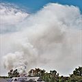
Sydney's George Street covered by smoke in December 2019; Orroral Valley fire seen from Tuggeranong; Damaged road sign along Bells Line of Road; Gospers Mountain bushfire; Smoke plume viewed from the ISS; Uncontained bushfire in South West Sydney. |
|
| Location | Australia (nationwide) |
| Statistics | |
| Cost | over $103 billion (2020 AUD) |
| Date(s) | June 2019 – May 2020 |
| Burned area | Approximately 18,636,079 hectares (46,050,750 acres) |
| Cause | Started fires
Enhanced fires
|
| Buildings destroyed | 9,352+
|
| Deaths |
|
| Season | |
|
← Previous season
Next season →
|
|
The 2019–20 Australian bushfire season, also known as Black Summer, was a time of very strong and widespread bushfires across Australia. These fires were much more intense than usual.
In June 2019, experts warned that the bushfire season might start early. This was because of very dry conditions and little moisture in the soil. Fires began in central Queensland even before the usual start of the season in August. Throughout the summer, hundreds of fires burned, mostly in the southeast of Australia. The biggest fires happened in December and January.
By March 2020, the fires had burned about 18.6 million hectares (about 46 million acres) of land. They destroyed over 5,900 buildings, including 2,779 homes. At least 34 people died directly from the fires. Sadly, nearly three billion land animals, mostly reptiles, were affected. Some endangered species might have even disappeared forever.
At its worst, the air quality became very dangerous in all southern and eastern states. The cost of these bushfires was huge, over 103 billion Australian dollars. This makes them Australia's most expensive natural disaster ever. Almost 80% of Australians were affected by the fires, either directly or indirectly. By January 2020, smoke from the fires had traveled 11,000 kilometers (about 6,800 miles) across the Pacific Ocean to Chile and Argentina.
From September 2019 to March 2020, fires badly hit many parts of New South Wales. In eastern and north-eastern Victoria, large forest areas burned out of control for four weeks. They then spread out of the forests in late December. Emergency situations were declared in New South Wales, Victoria, and the Australian Capital Territory. Firefighters from all over Australia came to help. The Australian Defence Force also helped with air support and supplies. Firefighters and equipment from Canada, New Zealand, Singapore, and the United States also joined the fight, especially in New South Wales.

During the fires, an air tanker and two helicopters crashed. The air tanker crash killed all three crew members. Two fire trucks were also involved in deadly accidents, killing three firefighters.
By March 4, 2020, all fires in New South Wales were put out. This was the first time since July 2019 that there were no fires in the state. The fires in Victoria were also contained. The last fire of the season happened in Lake Clifton, Western Australia, in early May.
There has been much discussion about why these fires were so big and intense. People talked about how fire management practices and climate change played a role. Many people around the world paid attention to these fires. People donated about 500 million Australian dollars to help victims and for wildlife recovery. Trucks full of donated food, clothes, and animal feed were sent to the affected areas.
Contents
What Caused the Fires?
On November 12, 2019, a "catastrophic" fire danger warning was given for the Greater Sydney area. This was the first time this highest level of warning had been used since 2009. A complete fire ban was put in place for seven regions.
Many people discussed the political impact of the fires. There was some debate when the New South Wales Government cut funding for fire services. Also, the Australian Prime Minister, Scott Morrison, took a holiday while two volunteer firefighters died. This caused some upset.

By January 14, 2020, about 18.6 million hectares (46 million acres) had burned across all Australian states and territories. Scientists from The University of Sydney estimated that 480 million mammals, birds, and reptiles were lost since September. They worried that whole species of plants and animals might have been wiped out. This number was later updated to more than a billion.
In New South Wales alone, the fires destroyed 2,176 homes, 48 other buildings, and over 2,000 outbuildings. Twenty people died in New South Wales since October. The fires in New South Wales burned more land than any other fires in the past 25 years. This was the state's worst bushfire season ever. New South Wales also had the longest continuously burning bushfire complex in Australia's history. It burned over 4 million hectares (9.9 million acres), with flames reported to be 70 meters (230 feet) high.
For comparison, the 2018 California wildfires burned 800,000 hectares (2 million acres). The 2019 Amazon rainforest wildfires burned 900,000 hectares (2.2 million acres).
Because of safety worries and public pressure, New Year's Eve fireworks were canceled in many parts of New South Wales. This included popular events in Campbelltown, Liverpool, Parramatta, and across Sydney's Northern Beaches. They were also canceled in Canberra, the nation's capital. When temperatures reached 49°C (120°F), the New South Wales Premier, Gladys Berejiklian, declared a new seven-day state of emergency starting January 3, 2020.
| State / territory | Fatalities | Homes lost |
Area (estimated) |
Notes | |
|---|---|---|---|---|---|
| ha | acres | ||||
| Northern Territory | 0 | 5 | 6,800,000 | 16,800,000 | Area includes mostly scrub fires; homes |
| New South Wales | 26 | 2,448 | 5,500,000 | 13,600,000 | Area; fatalities; homes |
| Queensland | 0 | 48 | 2,500,000 | 6,180,000 | Area includes scrub fires; homes |
| Western Australia | 0 | 1 | 2,200,000 | 5,440,000 | Area includes scrub fires; homes |
| Victoria | 5 | 396 | 1,500,000 | 3,710,000 | Area; fatalities; homes |
| South Australia | 3 | 151 | 490,000 | 1,210,000 | Area; fatalities; homes (KI:65) (AH:86) |
| Australian Capital Territory | 0 | 0 | 86,464 | 213,660 | Area |
| Tasmania | 0 | 2 | 36,000 | 89,000 | Area; homes |
| Total | 34 | 3,500+ | 18,736,070 | 46,300,000 | Total area estimate as of 13 February 2020; current figure may be more |
How Different Regions Were Affected by the Fires
New South Wales Fires
Fires on the North Coast
On September 6, the northern parts of New South Wales faced extreme fire dangers. Fires included the Long Gully Road fire near Drake. This fire burned until the end of October, killing two people and destroying 43 homes. The Mount McKenzie Road fire burned near Tenterfield, hurting one person and destroying one home. The Bees Nest fire near Ebor burned until November 12 and destroyed seven homes.
Fires on the Mid North Coast
A fire started on October 26 in Port Macquarie from a dry electrical storm. Firefighters tried to control it, but a sudden wind change made it worse. The fire spread towards Lake Cathie and over Lake Innes. Port Macquarie was covered in thick smoke. These fires burned 4,500 hectares (11,000 acres).

On the Carrai Plateau, a fire in wilderness areas was hard to fight because fire trails were blocked. This fire joined others and swept towards many towns. This fire burned over 40,000 hectares (99,000 acres), destroying many homes and killing three people.
Near Harrington, a fire started on October 28. This fire threatened the towns of Harrington, Crowdy Head, and Johns River. It burned north towards Dunbogan. This fire killed one person in Johns River and destroyed homes. It burned over 12,000 hectares (30,000 acres).

At Hillville, a fire grew very large due to hot and windy weather. It caused problems in the nearby town of Taree. Buses took students home early because of the danger. On November 9, the fire reached Old Bar and Wallabi Point, threatening many properties. The fire later threatened the Taree Service Centre. Water bombers helped protect it. This fire burned 31,268 hectares (77,260 acres).

In Dingo Tops National Park, a small fire became a huge emergency. It affected the village of Bobin, destroying many homes and the Bobin Public School. Fourteen homes were lost on one street in Bobin.
The 2019 Rally Australia, a motor racing event, was supposed to be held in Coffs Harbour in November. A week before, bushfires affected the area. Organizers shortened the event, but as the situation got worse, competitors asked for it to be canceled. The event was called off on November 12.
In late December 2019, fires started near Coopernook. They burned 278 hectares (690 acres) before being controlled.
Fires in the Blue Mountains and Hawkesbury

A large fire started in November at Gospers Mountain in the Wollemi National Park. It burned over 496,976 hectares (1.2 million acres) and threatened homes in the Hawkesbury and Lithgow areas. Firefighters tried to protect the Blue Mountains from this fire. They started a large backburn on December 14. But due to heavy fuel and strong winds, the backburn quickly went out of control. It threatened houses in Mount Wilson and Mount Irvine.

The fire then spread to Mount Tomah, Berambing, and Bilpin. It destroyed many houses and buildings. On December 19, the Gospers Mountain fire affected the Darling Causeway. It then split into two fires: the Grose Valley fire and the Gospers Mountain fire. On December 21, a very dangerous day, the Grose Valley fire hit Mount Victoria, Blackheath, and other towns, destroying dozens of homes.
By December 15, the Gospers Mountain fire had grown to 350,000 hectares (860,000 acres). This made it the biggest forest fire in Australian history. By December 27, it had burned over 500,000 hectares (1.2 million acres). The NSW Rural Fire Service said the fire was contained on January 12, 2020. It was caused by a lightning strike on October 26.
Fires in Sydney
.jpg)


On November 12, a fire started in the Lane Cove National Park south of Turramurra. Strong winds and extreme heat made it spread quickly. It affected the suburbs of South Turramurra. One house caught fire but was saved by firefighters. A large air tanker dropped fire retardant, helping to save the rest of the suburb. The fire was controlled hours later.
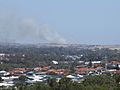
Because of the fires in nearby regions, Sydney had dangerous smoky haze for several days in December. The air quality was sometimes eleven times the hazardous level. It was even worse than in New Delhi.
On December 10, a fire affected the south-western Sydney suburbs of Nattai and Oakdale. It then moved to Orangeville and Werombi, threatening hundreds of houses and destroying one building. The fire continued to flare up, threatening properties in Oakdale and Buxton. It moved south-east towards the Southern Highlands. It affected the towns of Balmoral, Buxton, Bargo, and Tahmoor. Many properties were lost. Two firefighters died when a tree fell onto the road and their tanker rolled.
On December 31, a grass fire started in Prospect Hill in Western Sydney. It moved north towards Pemulwuy. The fire affected a large industrial area and threatened many properties. It was controlled by 9:30 pm. About 10 hectares (25 acres) and some historic Monterey pine trees were burned.
The Sydney City fireworks display was allowed to continue, despite protests. However, many fires were started across Sydney by illegal fireworks.
On January 4, Sydney’s western suburb Penrith had its hottest day ever at 48.9°C (120°F). This made it the hottest place on Earth at that time.
On January 5, a fire started in bushland at Voyager Point in Sydney's south-west. It spread quickly and affected houses in Voyager Point and Hammondville. Authorities closed the M5 Motorway due to smoke. Firefighters prevented any property losses, containing the fire to 60 hectares (150 acres).
Fires in the Southern Highlands
In late October, fires started in remote bushland near Lake Burragorang in the Kanangra-Boyd National Park. This area was very isolated and hard to reach. Firefighters struggled to control the fires as they spread. These fires eventually joined to become the Green Wattle Creek fire. The fire grew larger and more intense, burning towards the town of Yerranderie. Firefighters did backburning around the town, and helicopters helped control the fire. The fire passed Yerranderie but continued to burn towards south-western Sydney. On December 5, the fire jumped Lake Burragorang and started burning towards populated areas in the Wollondilly area.

On December 19, the fire continued east towards the Hume Highway. This caused the highway to close for several hours. It affected the township of Yanderra. Over the next few days, the fire threatened Yerrinbool and Hill Top.
The fire also spread west towards Oberon. The Oberon Correctional Centre was evacuated. On January 2, the fire hit the popular Jenolan Caves area, destroying several buildings. The main building, Jenolan Caves House, was saved.
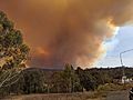
Fires on the South Coast
.jpg)
.jpg)
On December 30, weather conditions got much worse across the south-eastern areas of the state. Major fires broke out in many places. These fires made it harder for firefighters who were already busy with other fires. With temperatures expected to reach 41°C (106°F) on the South Coast, Premier Berejiklian declared a seven-day state of emergency on January 2, 2020. This included a large "tourist leave zone" from Nowra to the border of Victoria.
A fire on the South Coast started at Currowan and traveled to the coastline. It jumped across the Princes Highway, threatening properties around Termeil. Residents in Bawley Point, Kioloa, and other areas were told to evacuate or stay and protect their homes. One home was lost. By January 2, 2020, the Currowan fire was burning between Batemans Bay and Nowra. It had burned over 258,000 hectares (640,000 acres) and was out of control. This fire had merged with the Tianjara fire and the Clyde Mountain fire.
By December 26, the Clyde Mountain fire was burning south of the Kings Highway. Around 4 am on December 31, the fire crossed the Princes Highway near Mogo. The highway was closed. Around 7 am, the fire hit the southern side of Batemans Bay, destroying about ten businesses. The fire also crossed the Princes Highway and affected residential suburbs. Residents and holidaymakers had to flee to the beaches. On January 23, this fire became an emergency again, moving towards the coastal town of Moruya.
At nearby Lake Conjola, many homes were lost as embers jumped across the lake. On one street, only four houses were left standing. By January 2, at least two people had died, and one woman was missing. Other small towns like Bendalong and Manyana were also on fire. Holidaymakers were evacuated on January 3, 2020. By January 6, these areas were still without power.
By January 5, in the Bega Valley Shire, a border fire from north-eastern Victoria was burning north into New South Wales towards the town of Eden. It had affected settlements like Wonboyn and Kiah. Part of the fire was burning in hard-to-reach country. It had burned over 60,000 hectares (150,000 acres) and was out of control.
Fires in Riverina
On December 30, the Green Valley fire near Albury became a huge fire event due to extreme local conditions. The smoke plume rose to an estimated 8,000 meters (26,000 feet) and formed a special cloud called a pyro-cumulonimbus cloud. This created a firestorm. The wind was described as over 100 kilometers per hour (62 mph). Spot fires started over 5 kilometers (3.1 miles) ahead of the main fire.
Firefighters described what they thought was a tornado caused by the firestorm. It flattened trees and flipped a small fire vehicle. The tornado then hit a crew of firefighters, flipping their tanker and trapping them. One firefighter was killed, and several others were injured.
Fires in the Snowy Mountains
The Dunns Road fire was likely started by a lightning strike on December 28. In the Snowy Valleys area, by January 2, 2020, the Dunns Road fire had burned south of the Snowy Mountains Highway. Over 130,000 hectares (320,000 acres) were burned, and the fire was out of control. The NSWRFS told residents in Batlow and Wondalga to evacuate. Visitors to the Kosciuszko National Park were also evacuated, and the park was closed. 155 prisoners from the Mannus Correctional Centre near Tumbarumba were moved.
On January 3, 2020, the Dunns Road fire burned from Batlow into Kosciuszko National Park. It caused significant damage, badly hurting the Selwyn Snow Resort. It destroyed buildings in the town of Cabramurra and almost completely destroyed the historic area of Kiandra. Kiandra's historic former courthouse was left with only its walls standing. The fire was so hot that glass and aluminum in the windows melted. Many high country huts were also thought to be destroyed. By January 11, three fires had merged: the Dunns Road fire, the East Ournie Creek fire, and the Riverina's Green Valley fire. This created a 600,000-hectare (1.5 million-acre) "mega-fire."
_Lockheed_EC-130Q_Hercules_departing_HMAS_Albatross.jpg)
On January 23, a Lockheed C-130 Hercules large air tanker crashed near Cooma while dropping water on a fire. All three American crew members died.
Victoria Fires
On November 21, lightning strikes started a series of fires in East Gippsland. These fires first threatened the communities of Buchan and Sunny Point. On December 20, the Marthavale-Barmouth Spur fire grew, greatly endangering Tambo Crossing.
A cricket match between a Victoria team and New Zealand in Melbourne was canceled due to extreme heat.
On December 30, there were three active fires in East Gippsland covering over 130,000 hectares (320,000 acres). Another fire in the north-east was moving south towards Cudgewa. An evacuation warning was given for the East Gippsland town of Goongerah.
On the same day, a fire started in the Plenty Gorge Parklands in Melbourne's northern suburbs.
Fires reached the town of Mallacoota by 9:00 am on December 30, 2019. By 11:00 am on December 31, fires began to approach the vacation town of Lakes Entrance. Many holidaymakers chose to stay in the region despite evacuation warnings. About 4,000 people, including 3,000 tourists, stayed in Mallacoota as the fire got closer. Roads were cut off. On January 3, about 1,160 people from Mallacoota were evacuated by naval ships HMAS Choules and MV Sycamore.
On January 2, at 11:00 pm, Victorian Premier Daniel Andrews declared a state of disaster for several shires and alpine resorts. Emergency Management Commissioner Andrew Crisp said that 780,000 hectares (1.9 million acres) had burned. He also said that fifty fires were burning.
On January 3, Premier Daniel Andrews confirmed that two people had died from the East Gippsland fires.
Queensland Fires
On September 7, 2019, many out-of-control fires threatened towns across South Eastern and Northern Queensland. They destroyed eleven houses in Beechmont, seven houses in Stanthorpe, and one house at Mareeba. The next day, the historic Binna Burra Lodge was destroyed in the bushfire that hit Beechmont.
On September 9, a large fire affected the Peregian Beach area on the Sunshine Coast. It badly damaged 10 houses. In December 2019, Perigian Springs was threatened by bushfires again.
On November 9, a State of Fire Emergency was declared across 42 local government areas in Queensland. This was due to worsening fire conditions and fires threatening homes.
On November 11, a fire started in the Ravensbourne area near Toowoomba. It burned over 20,000 hectares (49,000 acres) and destroyed 6 houses. The air quality in Brisbane became very poor. Queensland’s chief health officer urged residents to stay indoors.
On November 13, a helicopter crashed while fighting fires near Pechey. The pilot had only minor injuries.
On November 23, the state of fire emergency was ended, but fire bans remained in affected areas.
On December 6, a house fire in Bundamba spread quickly to nearby bushland. The Queensland Fire and Emergency Services issued a warning. The next day, the fire worsened and threatened homes. It destroyed a shipping container full of fireworks. Residents in a 3-square-kilometer (1.2 sq mi) area were told to evacuate. One home was destroyed.
South Australia Fires

On November 11, 2019, ABC News reported an emergency bushfire warning for Port Lincoln. An uncontrolled fire was moving towards the town. The South Australian Country Fire Service sent ten water bombers and 26 ground crews. SA Power Networks cut power to the town.
A large fire broke out on Yorke Peninsula on November 20, 2019. It threatened the towns of Yorketown and Edithburgh. It destroyed at least 11 homes and burned about 5,000 hectares (12,000 acres). The fire was thought to have started from a sparking electrical transformer. A Boeing 737 water bombing aircraft from New South Wales helped protect Edithburgh.

On December 20, serious fires started in the Adelaide Hills and near Cudlee Creek. Initial winds pushed the fire towards Lobethal and Lenswood. The next morning, winds changed, threatening other towns. On the first day, the fires killed one person. More than 87 houses were destroyed, along with over 500 outbuildings and 278 cars. Christmas celebrations at Lobethal were canceled.
Also on December 20, an out-of-control bushfire started near Angle Vale. It burned through Buchfelde and across the Gawler River. An emergency warning was issued for several towns. One house was destroyed.

On January 7, 2020, the SA Government announced plans to remove 5,000-10,000 feral camels. This was to reduce competition for water and food. The cull would take place over five days, with camels shot from helicopters.
On Kangaroo Island in the Flinders Chase National Park, the Ravine bushfire burned over 15,000 hectares (37,000 acres). An emergency warning was issued on January 3, 2020, as the fire moved towards Vivonne Bay. The town of Parndana was evacuated. On January 4, it was confirmed that at least two people had died.
By January 6, about 170,000 hectares (420,000 acres) had burned. This was about a third of the island. Fires were still burning out of control. There were worries for endangered wildlife, like glossy black cockatoos, kangaroo Island dunnarts, and koalas.
Another emergency warning was issued on January 3 for a fire near Kersbrook. Water bombers helped limit the fire's spread. On January 9, the Kersbrook fire flared up again.
Tasmania Fires
In late October, four bushfires were burning near Scamander. Emergency warnings were issued in some areas. A large fire near Swansea also burned over 4,000 hectares (9,900 acres). Lightning strikes later started multiple fires in Southwest Tasmania.
Western Australia Fires
Two bushfires were burning in Geraldton on November 13, damaging homes.
A fire broke out in Yanchep on December 11, immediately triggering an emergency warning. The fire caused a service station to explode. On December 12, temperatures over 40°C (104°F) made the fire worse. The emergency warning area doubled, including parts of Guilderton and Brenton Bay. By December 13, the fire had grown to over 5,000 hectares (12,000 acres). By December 16, the fire was contained. About 13,000 hectares (32,000 acres) were burned, but only two buildings were damaged.
Australian Capital Territory Fires
In the Australian Capital Territory (ACT), the capital city Canberra was covered by thick bushfire smoke on New Year's Day. This smoke came from fires burning nearby in New South Wales. That day, Canberra had the worst air quality of any city in the world. It was about 23 times the hazardous level. Conditions continued the next day. Australia Post stopped deliveries in the ACT to keep postal workers safe. The first death directly linked to the poor air quality was recorded on January 2.
How the Fires Affected Other Countries
Carbon Emissions from the Fires
In mid-December 2019, a NASA analysis showed that the New South Wales and Queensland bushfires had released 250 million metric tons of carbon dioxide (CO2) since August 1. By January 2, 2020, NASA estimated that 306 million metric tons of CO2 had been released. To compare, Australia's total carbon emissions in 2018 were 535 million metric tons of CO2. While forests would normally reabsorb this carbon over time, it would take decades. It might not fully happen if long droughts hurt the forests' ability to regrow.
New Zealand and the Smoke

On New Year's Day 2020, a blanket of smoke from the Australian fires covered the whole South Island of New Zealand. This gave the sky an orange-yellow haze. People in Dunedin reported smelling smoke. MetService said the smoke would not affect New Zealand's weather or temperature. The smoke moved over the North Island the next day but was less intense. The smoke affected glaciers in New Zealand, giving the snow a brown tint.
Images for kids
-
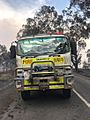
A heat damaged fire truck
-
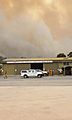
Country Fire Service
-
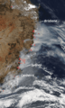
NASA satellite imagery on December 7, 2019, showing bushfires across the east coast of Australia
-
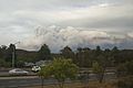
Bushfires as seen from the Main Western railway line west of Sydney.
-
A fire in Awaba, November 9, 2019
-
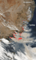
NASA satellite imagery on January 4, 2020, showing bushfires on southeast coast of Australia
-
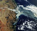
Satellite image of the smoke from the south-eastern Queensland and northern New South Wales bushfires in November 2019. At the time, the smoke spread eastward and reached Tasman Sea.
-
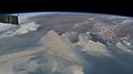
The smoke plume viewed from the International Space Station, January 4, 2020.
-
Smoke from bushfires seen in the sky of Perth in November 2019
-
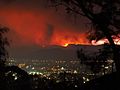
The Orroral Valley Fire viewed from Tuggeranong in southern Canberra
-
Smoke rising from the Orroral Valley fire, viewed from Tharwa, Australian Capital Territory


.jpg)


See also
 In Spanish: Temporada de incendios forestales de Australia 2019-2020 para niños
