
Mareeba facts for kids
Quick facts for kids MareebaQueensland |
|||||||||||||||
|---|---|---|---|---|---|---|---|---|---|---|---|---|---|---|---|
 |
|||||||||||||||

Mareeba
Location in Queensland
|
|||||||||||||||
| Established | 1877 | ||||||||||||||
| Postcode(s) | 4880 | ||||||||||||||
| Area | 480.3 km2 (185.4 sq mi) | ||||||||||||||
| Time zone | AEST (UTC+10:00) | ||||||||||||||
| LGA(s) | Shire of Mareeba | ||||||||||||||
| State electorate(s) | Cook | ||||||||||||||
| Federal Division(s) | Kennedy | ||||||||||||||
|
|||||||||||||||
|
|||||||||||||||
Mareeba is a country town in Far North Queensland, Australia. It is part of the Shire of Mareeba. The name "Mareeba" comes from an Aboriginal word. It means "meeting of the waters." This refers to where rivers and creeks meet. In 2021, about 11,825 people lived in Mareeba.
Contents
- Exploring Mareeba's Location
- Mareeba's Rich History
- Who Lives in Mareeba?
- Historic Places to See
- Mareeba's Weather and Climate
- What Mareeba's Economy is Like
- Learning in Mareeba: Schools
- Sports and Fun in Mareeba
- Community Services and Places
- Local Media and Entertainment
- Fun Things to Do in Mareeba
- Exciting Events in Mareeba
- Famous People from Mareeba
- Images for kids
Exploring Mareeba's Location
Mareeba is located about 417 meters (1,368 feet) above sea level. It sits where the Barron River, Granite Creek, and Emerald Creek all meet.
The main road through town is the Mulligan Highway. This road connects to the Kennedy Highway if you are coming from Cairns. Cairns is about 63.3 kilometers (40 miles) away.
Mareeba's Railway Connections
The Tablelands railway line runs through Mareeba. It enters from the north and leaves to the west. There are a few railway stations in the area:
- Floreat railway station (no longer used)
- Mareeba railway station
- Turkinje railway station (no longer used)
The Lotus Glen Correctional Centre is also nearby. It is about 14 kilometers (9 miles) outside Mareeba in Arriga.
Mareeba's Rich History
Before Europeans arrived, the Muluridji people lived around Mareeba. They were hunter-gatherers in this area. The name Mareeba means "meeting of the waters" in their language.
Early European Settlement
In 1875, James Venture Mulligan was the first European to officially see the Mareeba area. John Atherton was the first European to settle here in 1877. He brought cattle to Emerald End, just north of the town.
Mareeba quickly became a busy stop for Cobb & Co coaches. These coaches traveled from Port Douglas to Herberton. When the railway arrived in 1893, Mareeba grew into a busy town.
Schools and Services Grow
The Mareeba Post Office opened in 1893. Mareeba State School also opened on August 28, 1893. St Thomas of Villanova Catholic School opened in 1909.
Ambulance services started in Mareeba in 1922. In 1942, Mareeba even had a special rail ambulance. This train car carried patients by rail until 1983.
Mareeba During World War II
From 1942 to 1945, during World War II, Mareeba was very important. Up to 10,000 Australian and US soldiers used Mareeba Airfield. It was a stop for battles in New Guinea and the South West Pacific.
The Americans called it Hoevet Field. During this time, the army took over Mareeba State School. So, St Thomas’ Catholic School taught all the students in Mareeba.
Recent Developments
Mareeba Library opened in 1958. Mareeba State High School opened in 1960.
Mareeba is also home to an Albanian Australian community. The Mareeba Mosque was built by them and opened in 1970. It is dedicated to Australian soldiers who died in war.
St Stephen's Catholic College, another high school, opened in 2006. In 2011, an Agri-Science Hub opened in Mareeba. It focuses on farming research and education. James Cook University is a partner in this hub.
Who Lives in Mareeba?
In 2006, Mareeba had 6,806 people. By 2011, the population grew to 10,181. In 2016, there were 11,079 people.
Mareeba has a large Italian Australian community. In 2016, 1,608 people, or 10.8% of the town, were of Italian background. By 2021, the population reached 11,825 people.
Historic Places to See
Mareeba has several places listed for their historical importance:
- Mareeba Shire Hall, at 136 Walsh Street.
- Assay Office, at 167 Walsh Street.
- Mareeba Uniting Church, at 189 Walsh Street.
Mareeba's Weather and Climate
Mareeba has a tropical savanna climate. This means it has a short, hot wet season from December to March. It also has a long, warm dry season from April to November.
Because Mareeba is higher up, its average low temperatures are cooler. They range from about 14.0°C (57.2°F) in August to 21.5°C (70.7°F) in January and February. Mareeba gets about 875.9 mm (34.5 inches) of rain each year.
The town is known for its sunny weather. It gets about 86 clear days each year. Temperatures have ranged from a high of 40.7°C (105.3°F) to a low of 0.4°C (32.7°F).
What Mareeba's Economy is Like
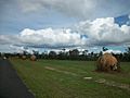
Mareeba Shire grows many different crops. These include avocados, mangoes, lychees, sugar cane, cashews, and coffee. Farmers also raise poultry (like chickens) and cattle.
Tobacco used to be a main crop, but it is no longer grown here. Tourism also brings money to the local economy. Many people visit Mareeba to see its attractions.
Learning in Mareeba: Schools
Mareeba has several schools for students of all ages:
- Mareeba State School is a government primary school (Prep–Year 6). It is located on Constance Street.
- St Thomas' School is a Catholic primary school (Prep–Year 6). It is also on Constance Street.
- Mareeba State High School is a government secondary school (Year 7–12). It is on Jasper Street.
- St Stephen's Catholic College is a Catholic secondary school (Year 7–12). It is located on McIver Road.
Sports and Fun in Mareeba
The Mareeba Gladiators are the local rugby league team. They play in the Cairns District Rugby League competition. They won the Premiership in 2007.
Community Services and Places
The Mareeba Shire Council runs a public library at 221 Byrnes Street. The Queensland Country Women's Association (CWA) has branches in Mareeba. They meet at the CWA Hall and at 15 Wilson Street.
St Thomas of Villanova's Catholic Church is on Constance Street. St Stephen's College also has a Catholic church. The Mareeba Mosque is located at 108 Walsh Street.
Local Media and Entertainment
Mareeba has several radio stations. These include:
- 4AM 558
- ABC Far North 720
- ABC Radio National 105.1
- ABC News Radio 101.1
- ABC Classic 105.9
- Triple J 107.5
- Hit FM 103.5
- KIK FM 88.7
- Black Star Radio FM 96.7
- Rhema FM 92.3
- Triple M 99.5
Fun Things to Do in Mareeba
There are many tourist attractions in the Mareeba Shire. You can visit the Golden Drop Mango Winery or Jaques Coffee Plantation. Other popular spots include:
- Coffee Works
- Mareeba Heritage Museum
- Mareeba Rock Wallabies and Granite Gorge Nature Park
- Emerald Creek Falls
- Davies Creek Falls
Exciting Events in Mareeba
The Mareeba Rodeo and Festival is held every year in July. It takes place at the Kerribee Park Rodeo Grounds. The first rodeo was held in 1949. In 2014, about 13,000 people attended the rodeo! A parade goes through town, and a Rodeo Queen is crowned.
The FNQ Country Music Festival and Talent Search is also held annually at Kerribee Park.
Each year, St Thomas's Catholic Church celebrates two special events:
- The Feast of Santo Nino (Jesus as a child) on the third Sunday of January. This is important for Filipino Australians.
- The Feast of Our Lady of the Chain on the second Sunday of September. This celebration includes a procession through Mareeba and fireworks.
Famous People from Mareeba
Many notable people have come from Mareeba, including:
- Aron Baynes (born 1986), a basketball player who won the 2014 NBA Finals.
- Harriett Brims (1864–1939), a pioneering female photographer.
- Steven Ciobo (born 1974), an Australian politician.
- Katie Page (born 1956), the CEO of Harvey Norman.
- Chris Sheppard (born 1981), a rugby league player.
- Wayne Srhoj (born 1982), an Australian footballer.
Images for kids
-
Moved termite mounds, Mareeba
-
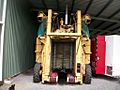
Coffee bean harvester, Mareeba


