Walkamin, Queensland facts for kids
Quick facts for kids WalkaminQueensland |
|||||||||||||||
|---|---|---|---|---|---|---|---|---|---|---|---|---|---|---|---|

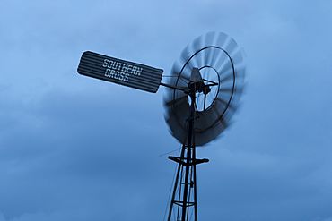
A storm approaching Walkamin during the wet season, 2014
|
|||||||||||||||
| Population | 532 (2021 census) | ||||||||||||||
| • Density | 11.295/km2 (29.25/sq mi) | ||||||||||||||
| Postcode(s) | 4872 | ||||||||||||||
| Area | 47.1 km2 (18.2 sq mi) | ||||||||||||||
| Location | |||||||||||||||
| LGA(s) | Tablelands Region | ||||||||||||||
| State electorate(s) | Hill | ||||||||||||||
| Federal Division(s) | Kennedy | ||||||||||||||
|
|||||||||||||||
|
|||||||||||||||
Walkamin is a small town in the countryside of Queensland, Australia. It is located in the Tablelands Region. In 2021, about 532 people lived in Walkamin.
Contents
Where is Walkamin Located?
Walkamin is found on the Atherton Tableland in Far North Queensland. It sits between the towns of Mareeba and Tolga. The main road, the Kennedy Highway, goes right through the town.
What is the Climate Like in Walkamin?
Walkamin has a tropical savannah climate. This means it has a hot and wet season from November to April. The dry season, from April to November, is warm and sunny. The town's higher location makes the weather a bit cooler and drier.
The hottest month is December, with average highs around 30.7°C. July is the coolest, with highs around 23.4°C. The coldest month is July, with average lows around 13.1°C. Walkamin gets about 1043.9 mm of rain each year. The rain mostly falls during the wet season.
| Climate data for Walkamin (17º07'48"S, 145º25'48"E, 594 m AMSL) (1965-2024 normals and extremes) | |||||||||||||
|---|---|---|---|---|---|---|---|---|---|---|---|---|---|
| Month | Jan | Feb | Mar | Apr | May | Jun | Jul | Aug | Sep | Oct | Nov | Dec | Year |
| Record high °C (°F) | 39.8 (103.6) |
36.5 (97.7) |
35.0 (95.0) |
32.6 (90.7) |
31.5 (88.7) |
32.0 (89.6) |
31.7 (89.1) |
33.9 (93.0) |
35.8 (96.4) |
38.8 (101.8) |
39.8 (103.6) |
38.3 (100.9) |
39.8 (103.6) |
| Mean daily maximum °C (°F) | 29.9 (85.8) |
29.2 (84.6) |
28.2 (82.8) |
26.7 (80.1) |
25.0 (77.0) |
23.6 (74.5) |
23.4 (74.1) |
24.8 (76.6) |
27.1 (80.8) |
29.4 (84.9) |
30.6 (87.1) |
30.7 (87.3) |
27.4 (81.3) |
| Mean daily minimum °C (°F) | 20.4 (68.7) |
20.5 (68.9) |
19.7 (67.5) |
18.2 (64.8) |
16.2 (61.2) |
14.0 (57.2) |
13.1 (55.6) |
13.4 (56.1) |
14.8 (58.6) |
16.8 (62.2) |
18.6 (65.5) |
19.8 (67.6) |
17.1 (62.8) |
| Record low °C (°F) | 14.1 (57.4) |
12.6 (54.7) |
11.3 (52.3) |
9.9 (49.8) |
5.6 (42.1) |
3.4 (38.1) |
2.6 (36.7) |
3.6 (38.5) |
7.7 (45.9) |
8.9 (48.0) |
12.4 (54.3) |
12.6 (54.7) |
2.6 (36.7) |
| Average precipitation mm (inches) | 234.6 (9.24) |
244.9 (9.64) |
205.4 (8.09) |
54.6 (2.15) |
27.0 (1.06) |
18.1 (0.71) |
13.7 (0.54) |
10.6 (0.42) |
8.7 (0.34) |
22.8 (0.90) |
68.2 (2.69) |
132.0 (5.20) |
1,043.9 (41.10) |
| Average precipitation days (≥ 1.0 mm) | 13.4 | 14.6 | 12.4 | 8.4 | 5.6 | 3.8 | 2.8 | 2.4 | 2.0 | 3.2 | 5.5 | 9.7 | 83.8 |
| Mean monthly sunshine hours | 210.8 | 172.3 | 204.6 | 216.0 | 223.2 | 222.0 | 238.7 | 263.5 | 276.0 | 297.6 | 267.0 | 244.9 | 2,836.6 |
| Percent possible sunshine | 52 | 48 | 54 | 62 | 64 | 67 | 69 | 74 | 77 | 77 | 69 | 60 | 64 |
| Source: Bureau of Meteorology (1965-2024 normals and extremes) | |||||||||||||
What is the History of Walkamin?
The name Walkamin comes from its railway station. The railway department named it on November 8, 1943. They used a suggestion from Sydney Lionel May. He suggested it because it was the name of an Aboriginal language from the area, likely the Wakaman language.
Walkamin State School first opened its doors on May 19, 1958. In 1982, the school celebrated its 25th birthday.
The Walkamin Research Station was started by the Queensland Government in late 1959. Its job was to study how to best use water from the Tinaroo Dam for farming.
Education in Walkamin
Walkamin State School is a primary school for students from Prep to Year 6. It is located at 40 Wattle Street. In 2016, the school had 51 students and 3 teachers.
What is the Economy of Walkamin Like?
The Walkamin Research Station is very important to the local economy. In 2017, it was researching crops like mangoes, peanuts, and coffee. They also studied hardwoods, legumes, maize, and lucerne. The station can also do research on aquaculture (farming fish or other water creatures), but they didn't have any projects in that area in 2017. The research station also has a special farm in Kairi, near Lake Tinaroo.
Fun Things to Do in Walkamin
The Mount Uncle Distillery makes different types of drinks from local fruits. In 2015, they won several awards at a competition in Hong Kong. They won a gold medal for their Iridium rum. They also won silver medals for their gin, vodka, and whiskey. The owner believes Walkamin's climate helps their drinks age faster.
The FNQ Country Music Festival and Talent Search is held every year. It takes place at Kerribee Park Rodeo Grounds in Mareeba. The Walkamin Country Music Club hosts this event.
 | Selma Burke |
 | Pauline Powell Burns |
 | Frederick J. Brown |
 | Robert Blackburn |


