
Cairns facts for kids
Quick facts for kids CairnsQueensland |
|||||||||
|---|---|---|---|---|---|---|---|---|---|
|
|
|||||||||

Cairns
Location in Queensland
|
|||||||||
| Population | 153,181 (2021) (15th) | ||||||||
| • Density | 602.36/km2 (1,560.1/sq mi) | ||||||||
| Established | 1876 | ||||||||
| Postcode(s) | 4870 | ||||||||
| Elevation | 7 m (23 ft) | ||||||||
| Area | 254.3 km2 (98.2 sq mi) | ||||||||
| Time zone | AEST (UTC+10:00) | ||||||||
| Location |
|
||||||||
| LGA(s) | Cairns Region | ||||||||
| County | Nares | ||||||||
| State electorate(s) |
|
||||||||
| Federal Division(s) | |||||||||
|
|||||||||
_(cropped).jpg)


Cairns (pronounced like "Cairns") is a city in Queensland, Australia. It's located on the tropical northeast coast of Far North Queensland. In 2021, about 153,181 people lived in Cairns. The local Indigenous people, the Gimuy Walubara Yidinji, call the area Gimuy.
The city was started in 1876. It was named after Sir William Wellington Cairns, who was the Governor of Queensland. This happened after gold was found nearby in the Hodgkinson River. During World War II, Cairns was an important base for the Allied Forces. They used it during battles like the Battle of the Coral Sea. By the late 1900s, Cairns became a big place for international tourism. Today, it's a major city in the region.
Cairns' economy mainly relies on tourism, healthcare, and education. It also has important aviation, marine, and defence industries. The city's total economic output was about $11.4 billion in 2023. Cairns International Airport is Australia's seventh busiest airport. Cairns is also a big port for cruise ships, serving both local and international visitors.
Cairns is a top spot for tourists because it's close to two amazing UNESCO World Heritage Sites. These are the Daintree Rainforest, which is part of the Wet Tropics of Queensland, and the Great Barrier Reef. The Great Barrier Reef is known as one of the seven natural wonders of the world.
Contents
- History of Cairns
- People in Cairns
- Geography of Cairns
- City Facilities
- Historic Places
- How Cairns is Governed
- Cairns Economy
- Transport in Cairns
- Defence Facilities
- Sister Cities
- Education in Cairns
- Sports and Fun
- Community and Culture
- Indigenous Languages
- Famous People from Cairns
- Images for kids
- See also
History of Cairns
Before British settlers arrived, the Cairns area was home to the Gimuy Walubara Yidinji people. They still have their native title rights to the land. The Yidinji language is an Aboriginal language spoken in this area.

From 1770 to the early 1870s, the British called this area Trinity Bay. European fishermen started visiting in the late 1860s. There was a large well on the modern-day Cairns foreshore that these fishermen used. In 1872, there was a fight between the local Yidinji people and a fisherman over this well. After this, the area was called Battle Camp.
In 1876, people needed a port to send gold from the Hodgkinson goldfields. So, they looked for a good spot. Battle Camp was chosen and renamed Cairns. This was to honour the Governor of Queensland, William Cairns. The area was mostly mangrove swamps and sand. Workers slowly cleared the swamps. They filled the land with mud, sawdust, and rocks.


Building a railway to Herberton in 1886 also helped. The railway opened up land for farming crops like sugar cane, corn, and bananas. This farming success helped Cairns become an important port.
During World War II, the Allied Forces used Cairns as a base. The US Army Air Forces and Royal Australian Air Force had bases here. There was also a big military seaplane base in Trinity Inlet. Combat missions were flown from Cairns during the Battle of the Coral Sea in 1942.
After World War II, Cairns slowly grew into a tourism hub. The opening of the Cairns International Airport in 1984 made it a popular place for international tourism, especially for visitors from Japan. By 2021, the population of Cairns had grown to 153,181 people.
People in Cairns
In 2021, Cairns had a population of 153,181 people.
- About 9.7% of the people were Aboriginal and Torres Strait Islander people.
- Most people (68.2%) were born in Australia. Other common birthplaces included England (4.0%), New Zealand (2.9%), and Papua New Guinea (1.5%).
- Most people (76.1%) spoke only English at home. Other languages included Japanese, Nepali, and Mandarin.
- For religion, many people said they had no religion (41.9%). Others were Catholic (19.7%) or Anglican (9.8%).
Cairns is close to Melanesia, so many people in the region have Melanesian backgrounds. Cairns has a large community of people from Papua New Guinea. About 10,000 Papua New Guineans live in Cairns, which is more than anywhere else outside of Papua New Guinea.
Geography of Cairns


Cairns is on the east coast of the Cape York Peninsula. It sits on a narrow strip of land between the Coral Sea and the Great Dividing Range. The city centre is on Trinity Inlet. South of Trinity Inlet is the Indigenous community of Yarrabah. Some parts of Cairns are on flat areas that can flood. The Mulgrave River and Barron River flow near Cairns, but not through the city centre.
City Layout
.JPG)
Cairns is a city that stretches out in a line. It runs about 52 kilometres (32 miles) from south to north. The city has grown a lot, with new suburbs built on land that used to be sugar cane farms.
The Northern Beaches are a group of beach towns along the coast. These include places like Machans Beach, Trinity Beach, and Palm Cove.
The suburb of Smithfield is inland, near the mountains. It's a main hub for the Northern Beaches, with a large shopping centre.
South of Smithfield, near the Barron River flood plain, are suburbs like Freshwater and Redlynch. These areas are separated from Cairns city by Mount Whitfield.
The city centre of Cairns is next to suburbs like Cairns North and Edge Hill.
Southside Cairns is a narrow area between Trinity Inlet and the Lamb Range. It includes suburbs like White Rock and Edmonton. These areas are served by the Bruce Highway.
Climate

| Weather chart for Cairns Airport, Queensland, Australia | |||||||||||||||||||||||||||||||||||||||||||||||
|---|---|---|---|---|---|---|---|---|---|---|---|---|---|---|---|---|---|---|---|---|---|---|---|---|---|---|---|---|---|---|---|---|---|---|---|---|---|---|---|---|---|---|---|---|---|---|---|
| J | F | M | A | M | J | J | A | S | O | N | D | ||||||||||||||||||||||||||||||||||||
|
389
32
24
|
479
32
24
|
368
31
23
|
176
30
22
|
81
28
20
|
43
27
19
|
36
26
17
|
27
27
17
|
29
29
19
|
63
30
21
|
85
31
23
|
190
32
24
|
||||||||||||||||||||||||||||||||||||
| temperatures in °C precipitation totals in mm |
|||||||||||||||||||||||||||||||||||||||||||||||
|
Imperial conversion
|
|||||||||||||||||||||||||||||||||||||||||||||||
Cairns has a tropical climate, which means it's hot and humid. It has a wet season from November to May with heavy rain. The dry season is from June to October, with less rain. Cairns gets almost 2000 millimetres (79 inches) of rain each year.
Cairns has hot, humid summers and very warm winters. The highest average temperatures are around 31.7°C (89.1°F) in January. The lowest average temperatures are around 26.2°C (79.2°F) in July. Heavy rain during the wet season can sometimes cause big floods in the Barron and Mulgrave Rivers. This can cut off roads and railways to the city.
| Climate data for Cairns Airport, Queensland, Australia (1991-2020 normals, extremes 1941-present); 2 m AMSL | |||||||||||||
|---|---|---|---|---|---|---|---|---|---|---|---|---|---|
| Month | Jan | Feb | Mar | Apr | May | Jun | Jul | Aug | Sep | Oct | Nov | Dec | Year |
| Record high °C (°F) | 40.4 (104.7) |
40.0 (104.0) |
37.7 (99.9) |
36.8 (98.2) |
31.3 (88.3) |
30.8 (87.4) |
30.1 (86.2) |
31.4 (88.5) |
33.9 (93.0) |
36.0 (96.8) |
42.6 (108.7) |
40.5 (104.9) |
42.6 (108.7) |
| Mean maximum °C (°F) | 33.6 (92.5) |
33.3 (91.9) |
32.7 (90.9) |
31.1 (88.0) |
29.4 (84.9) |
28.0 (82.4) |
27.6 (81.7) |
28.5 (83.3) |
29.9 (85.8) |
31.3 (88.3) |
32.3 (90.1) |
33.5 (92.3) |
33.6 (92.5) |
| Mean daily maximum °C (°F) | 31.7 (89.1) |
31.5 (88.7) |
30.9 (87.6) |
29.6 (85.3) |
28.0 (82.4) |
26.6 (79.9) |
26.2 (79.2) |
27.0 (80.6) |
28.7 (83.7) |
29.9 (85.8) |
31.1 (88.0) |
31.8 (89.2) |
29.4 (85.0) |
| Daily mean °C (°F) | 27.9 (82.2) |
27.8 (82.0) |
27.2 (81.0) |
25.8 (78.4) |
24.1 (75.4) |
22.6 (72.7) |
21.7 (71.1) |
22.2 (72.0) |
23.8 (74.8) |
25.4 (77.7) |
26.8 (80.2) |
27.8 (82.0) |
25.3 (77.5) |
| Mean daily minimum °C (°F) | 24.0 (75.2) |
24.1 (75.4) |
23.4 (74.1) |
22.0 (71.6) |
20.1 (68.2) |
18.5 (65.3) |
17.2 (63.0) |
17.3 (63.1) |
18.8 (65.8) |
20.8 (69.4) |
22.5 (72.5) |
23.7 (74.7) |
21.0 (69.9) |
| Mean minimum °C (°F) | 22.1 (71.8) |
22.3 (72.1) |
21.4 (70.5) |
19.6 (67.3) |
16.8 (62.2) |
13.9 (57.0) |
13.1 (55.6) |
13.9 (57.0) |
15.8 (60.4) |
18.0 (64.4) |
20.2 (68.4) |
21.6 (70.9) |
13.1 (55.6) |
| Record low °C (°F) | 18.2 (64.8) |
17.9 (64.2) |
17.7 (63.9) |
13.0 (55.4) |
10.1 (50.2) |
6.2 (43.2) |
7.3 (45.1) |
7.8 (46.0) |
9.3 (48.7) |
12.4 (54.3) |
14.6 (58.3) |
17.1 (62.8) |
6.2 (43.2) |
| Average precipitation mm (inches) | 388.7 (15.30) |
479.0 (18.86) |
368.2 (14.50) |
175.9 (6.93) |
81.2 (3.20) |
42.7 (1.68) |
35.9 (1.41) |
26.6 (1.05) |
29.3 (1.15) |
63.4 (2.50) |
85.1 (3.35) |
190.0 (7.48) |
1,966 (77.41) |
| Average precipitation days (≥ 1.0 mm) | 15.8 | 15.4 | 14.6 | 14.2 | 9.9 | 7.1 | 5.7 | 4.5 | 4.2 | 6.0 | 8.3 | 10.6 | 116.3 |
| Average relative humidity (%) | 71.0 | 74.5 | 70.5 | 70.5 | 68.5 | 66.5 | 63.5 | 62.0 | 60.0 | 60.5 | 63.5 | 67.0 | 66.5 |
| Average dew point °C (°F) | 22.9 (73.2) |
23.5 (74.3) |
22.0 (71.6) |
20.7 (69.3) |
18.6 (65.5) |
16.7 (62.1) |
15.3 (59.5) |
15.6 (60.1) |
17.0 (62.6) |
18.7 (65.7) |
20.5 (68.9) |
22.0 (71.6) |
19.5 (67.0) |
| Mean monthly sunshine hours | 213.9 | 175.2 | 204.6 | 210.0 | 220.1 | 210.0 | 232.5 | 251.1 | 270.0 | 279.0 | 258.0 | 241.8 | 2,766.2 |
| Mean daily sunshine hours | 6.9 | 6.2 | 6.6 | 7.0 | 7.1 | 7.0 | 7.5 | 8.1 | 9.0 | 9.0 | 8.6 | 7.8 | 7.6 |
| Percent possible sunshine | 54 | 50 | 55 | 61 | 63 | 63 | 67 | 69 | 74 | 73 | 67 | 60 | 63 |
| Source 1: Australian Bureau of Meteorology (1991-2020 normals) | |||||||||||||
| Source 2: Australian Bureau of Meteorology (1941-present extremes) | |||||||||||||
Tropical Cyclones
Cairns often experiences tropical cyclones, which are strong storms. They usually happen between November and May. Some notable cyclones that have affected Cairns include Cyclone Yasi (2011) and Cyclone Larry (2006).
City Facilities
The Cairns City Library is a great place to visit. It opened in 1979 and has been updated several times. You can find many books and resources there, and it has free Wi-Fi.
Historic Places
Cairns has many places listed for their history. These include the Cairns-to-Kuranda railway line, old hotels, and important government buildings. The Flecker Botanical Gardens and the Cairns War Memorial are also historic sites. These places show the city's past.
How Cairns is Governed

Cairns is part of the Cairns Region local government area. This area is managed by a Regional Council. The Council has a mayor and 9 councillors. They are elected by the people every four years.
The Cairns Region was formed by joining three smaller areas. The original City of Cairns joined with the Shire of Mulgrave in 1995. Later, the Shire of Douglas also joined, but then separated again in 2014.
Cairns has three representatives in the Queensland Parliament. These are from the areas of Barron River, Cairns, and Mulgrave. The city also has representatives in the Federal Parliament from the areas of Leichhardt and Kennedy.
Cairns Economy

.jpg)
Cairns is the main business centre for Far North Queensland. It's home to many government offices.
Tourism in Cairns
Tourism is a huge part of Cairns' economy. It's the fourth most popular place for international tourists in Australia. This is after Sydney, Melbourne, and Brisbane. Cairns also attracts many Australian holidaymakers. More and more visitors from China are coming to Cairns too.
The city is a gateway to the Great Barrier Reef and the Wet Tropics of Queensland. Many tours to the Great Barrier Reef start from Cairns.
The Cairns esplanade has a popular swimming lagoon. It also has barbecue areas for families to enjoy.
Shopping and Business
Cairns has several shopping centres. The biggest ones are Cairns Central in the city centre and Stockland Cairns in Earlville. There are also shopping complexes in other suburbs like Mount Sheridan and Smithfield.
In 2010, a new office building called William McCormack Place opened. It was the first building in Cairns to get a 6-star green rating for being environmentally friendly.
Media in Cairns
.jpg)
The Cairns Post is the main daily newspaper in Cairns. You can also read The Courier-Mail from Brisbane and the national newspaper The Australian.
Cairns has five television stations. These include commercial stations like WIN Television and Seven Queensland. There are also public broadcasters like the ABC and SBS.
For radio, Cairns has many stations. These include ABC Far North, Triple J (for youth), and commercial stations like Star 102.7. There are also local community radio stations.
Farming and Industry
The land around Cairns is still used for sugar cane farming. However, new suburbs are being built on some of this land as the city grows. The Mulgrave Sugar Mill is located in Gordonvale.
The Barron Gorge Hydroelectric Power Station is nearby. It uses water from the Barron River to create clean energy.
Transport in Cairns
Cairns is an important transport hub in Far North Queensland. It connects the Cape York Peninsula and Gulf of Carpentaria regions to the rest of the state. Cairns International Airport is vital for tourism.
Roads

The Bruce Highway runs for about 1,700 kilometres (1,056 miles) from Brisbane and ends in Woree, a southern suburb of Cairns. The Captain Cook Highway starts north of Cairns and goes northwest to Mossman.
The Kennedy Highway starts north of Cairns and goes up the mountains to Kuranda and then to Mareeba on the Atherton Tableland.
The Gillies Highway starts in Gordonvale and goes up the Gillies Range to Atherton.
Buses
Cairns has a public bus network that covers most of the city. Buses connect areas from Palm Cove in the north to Gordonvale in the south. The main bus stations are in the CBD. Long-distance buses also connect Cairns to Brisbane and other cities.
Trains

Cairns railway station is the end point for Queensland's North Coast railway line from Brisbane. Passenger and freight trains use this line.
The Kuranda Scenic Railway is a popular tourist train. It goes up the Macalister Range to Kuranda, offering beautiful views.
Cairns also has a special narrow gauge railway network. These "cane trains" carry harvested sugar cane to the Mulgrave Sugar Mill in Gordonvale.
Airport

Cairns International Airport is about 7 kilometres (4.3 miles) north of Cairns City. It has terminals for domestic and international flights. The airport connects Cairns to major Australian cities and many tourist destinations. It's also a base for the Royal Flying Doctor Service.
Port

The Cairns Seaport is on Trinity Inlet. It's a busy port for tourist boats that go to the Great Barrier Reef every day. Large catamarans carry hundreds of passengers. Cairns Port is also a stop for cruise ships exploring the South Pacific. It handles freight too, sending goods to towns on the Cape York Peninsula.
The port handles over a million tonnes of cargo each year. Most of this is bulk goods like petroleum, sugar, and fertiliser. Many fishing trawlers are also based at the port. There's also a marina for private yachts and tourist boats.
Defence Facilities
The Royal Australian Navy has a base in Cairns called HMAS Cairns. About 1000 people work there. The base supports nine vessels, including patrol boats and survey ships.
Porton Barracks, in Edmonton, is home to the Australian Army's 51st Battalion, Far North Queensland Regiment. These are part of the Australian Army Reserve.
Sister Cities
Cairns has "sister city" relationships with several cities around the world. This means they share cultural and educational ties. These cities include:
 Lae, Papua New Guinea (since 1984)
 Minami, Japan (since 1969)
- Oyama, Japan (since 2006)
 Riga, Latvia (since 1990)
 Scottsdale, USA (since 1987)
 Sidney, Canada (since 1984)
 Zhanjiang, China (since 2005)
You can see items from Cairns' sister cities at the Cairns City Library.
Education in Cairns
Cairns has many primary and secondary schools. There are public schools, run by the government, and private schools.
Catholic schools are managed by Catholic Education Cairns. They have many primary and secondary schools. The oldest Catholic college is St Augustine's.
There are also other independent schools like Peace Lutheran College and Trinity Anglican School.
The Cairns Campus of James Cook University is in Smithfield. CQUniversity Australia also has a study centre in Cairns. The city has a TAFE college for vocational training and a School of the Air base.
Sports and Fun
Football and Rugby
Cairns has a soccer team called Far North Queensland Heat. They play in the NPL Queensland league. Many famous Australian soccer players are from this region.
Cairns also has an Australian rules football competition called AFL Cairns. Cazalys Stadium hosts one Australian Football League (AFL) game each season.
The Northern Pride rugby league team plays in the Queensland Cup. They are a feeder team for the North Queensland Cowboys in the National Rugby League. Cairns also has many local rugby league clubs.

Other Sports
Cairns has a baseball league at Trinity Beach. It also has a National Basketball League (NBL) team, the Cairns Taipans. Their home court is the Cairns Convention Centre.
Cairns is a major place for water sports and scuba diving because it's so close to the Great Barrier Reef. Other popular activities for tourists include whitewater rafting, skydiving, and snorkelling.
Sporting Facilities

Important sports venues include Barlow Park, Cazalys Stadium, and the Cairns Convention Centre. The Cairns Showground is also used for sports events.
Community and Culture
The Cairns & District Chinese Association works to preserve Chinese culture and heritage in Cairns. They organise events like the Chinese New Year Festival and dragon boat racing.
The Cairns Historical Society runs the Cairns Museum. It's in the old Cairns School of Arts building. They collect and share information about Cairns' history.
St Monica's Catholic Cathedral is a beautiful church in Cairns.
Indigenous Languages
The Yidiny language is an important Indigenous language in the Cairns area.
Irukandji language is another language of Far North Queensland. It is spoken around the Kuranda Range and Lower Barron River.
Yumplatok (also called Torres Strait Creole) is a language from the Torres Strait Islands. It's a mix of Standard Australian English and traditional languages. Many Torres Strait Islanders speak it, including those living in Cairns.
There are four main traditional owner groups in the Cairns region. These groups represent the rights and interests of the Indigenous peoples of the area. They include the Dawul Wuru (Yirrganydji) Aboriginal Corporation and the Djabugay people.
Famous People from Cairns
Many well-known people are from Cairns, including:
- Christine Anu, a pop singer and actress.
- Aron Baynes, a basketball player who played in the NBA.
- Matt Bowen, a famous Rugby League player.
- Mary Fowler, a soccer player for the Australian women's national team.
- Catriona Gray, who won Miss Universe in 2018.
- Justin Hodges, an international Rugby League player.
- Nathan Jawai, the first Indigenous Australian to play in the NBA.
- Susan Kiefel, who became the Chief Justice of the High Court of Australia.
- Brenton Thwaites, an actor.
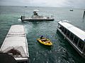
Images for kids
-
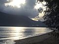
View of the pier and Esplanade at dawn
-
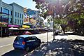
City centre
-
Glass bottom boats and a Semi submarine at Green Island, Great Barrier Reef, outer Cairns
-
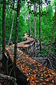
Jack Barnes Bicentennial Mangrove Boardwalk
-
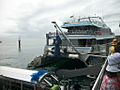
A Great Barrier Reef ferry, Green Island, outer Cairns
-
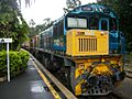
Kuranda scenic railway, Kuranda
-
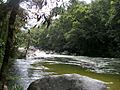
Mossman river and Gorge, Daintree National Park, outskirts of Cairns
-
Moved termite mounds, Mareeba, Queensland, outskirts of Cairns
-
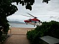
Queensland rescue Helicopter, Green Island, Great Barrier Reef, outskirts of Cairns
-
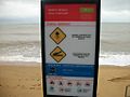
Marine stingers sign, Trinity beach, Cairns
-
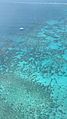
Hastings Reef
-
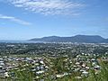
City landscape

.JPG)


See also
 In Spanish: Cairns para niños
