Torres Strait Islands facts for kids
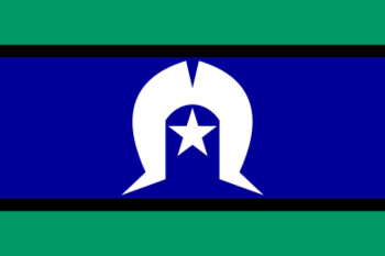
Flag of the Torres Strait Islanders
|
|
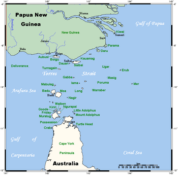
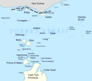
Location of the Torres Strait Islands, between Cape York Peninsula, Queensland, Australia and Papua New Guinea.
|
|
| Geography | |
|---|---|
| Coordinates | 10°34′44″S 142°13′12″E / 10.579°S 142.220°E |
| Area | 566 km2 (219 sq mi) |
| Administration | |
|
Australia
|
|
| Torres Strait Regional Authority | |
| Capital and largest city | Thursday Island |
| Chairmana Chief Executive Officera |
Napau Pedro Stephen Leilani Bin-Juda |
| Demographics | |
| Demonym | Torres Strait Islander |
| Population | 4,514 (2016) |
| Languages | English; important local languages: Kalau Lagau Ya, Meriam Mir, Torres Strait Creole |
The Torres Strait Islands are a group of at least 274 small islands. They are located in the Torres Strait, a waterway between northern Australia's Cape York Peninsula and the island of New Guinea. These islands cover a large ocean area of 48,000 square kilometres. However, their total land area is much smaller, only 566 square kilometres.
The islands are home to the Torres Strait Islanders, who are the original people of this area. In 1770, Lieutenant James Cook claimed the eastern part of Australia for Britain. This happened at Possession Island. But British control over the Torres Strait Islands only began in 1862. Today, most of the islands are part of Queensland, a state in Australia. They are managed by the Torres Strait Regional Authority, which is part of the Australian government. A few islands very close to New Guinea belong to Papua New Guinea. The most important of these is Daru Island.
Only 17 of the islands have people living on them. In 2016, the population of the Torres Strait Islands was 4,514 people. About 91.8% of these people identified as Torres Strait Islanders. Even though they are counted as Indigenous Australians, Torres Strait Islanders are mostly Melanesians. This means they have different ethnic and cultural backgrounds from Aboriginal Australians.
Contents
History of the Torres Strait Islands
Early Explorers and British Claims
The Spanish explorer Luís Vaez de Torres sailed through the Torres Strait in 1606. He was part of an expedition looking for a large southern land.
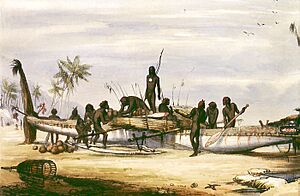
In 1770, Lieutenant James Cook claimed the eastern part of Australia for Britain. He called it New South Wales. This claim was made at Possession Island.
British control in the Torres Strait Islands started later, in 1862. John Jardine was appointed as the Government Resident. He first set up a small settlement on Albany Island. Later, on August 1, 1864, he moved to Somerset Island.
Pearl and Trochus Shell Industry
Torres Strait Islanders had been diving for pearl shells for a long time. In the 1860s, a big international industry for pearl and trochus shells began. These shells were used for decoration. By the 1890s, the islands provided more than half of the world's pearl shells.
Coming of the Light
The London Missionary Society (LMS) arrived on Erub (Darnley Island) on July 1, 1871. This event is very important to the Islanders. When the Anglican Church took over the mission later, they called this day "The Coming of the Light". It is now celebrated every year on July 1.
Queensland's Borders and Challenges
In 1872, Queensland's border was extended. It included Thursday Island and other islands within 60 miles of the Queensland coast.
In June 1875, a measles sickness spread. It killed about 25% of the island population. Some islands lost up to 80% of their people. The Islanders had no natural protection against European diseases.
In 1879, Queensland officially took control of the other Torres Strait Islands. They became part of the British colony of Queensland. After 1901, they became part of the Australian state of Queensland. Some of these islands are very close to the coast of New Guinea.
Local Leadership and Protection
In 1885, John Douglas became the Government Resident Magistrate on Thursday Island. He visited all the islands and was well-known. He set up a system where the traditional chief of each island became a chief magistrate. This helped support the local customs. He also created Native Police. On Saibai, these police were given rifles. They used them to protect against attacks from the Marind-anim (also known as Tugeri). These were headhunters from the New Guinea coast.
Cultural Research
From 1898 to 1899, the Cambridge Anthropological Expedition visited the islands. They collected about 2,000 cultural items. They said they wanted to save them from being destroyed by missionaries. However, many items collected by Samuel Macfarlane were later sold to museums in Europe.
20th Century to Today
In 1904, Torres Strait Islanders faced legal rules about their land and lives.
During World War II, many Torres Strait Islander people joined the Australian Army. They served in the Torres Strait Light Infantry Battalion.
From 1960 to 1973, Margaret Lawrie recorded many myths and legends from the Islanders. Her work helps preserve their culture. It is now recognized by UNESCO's Memory of the World Programme.
Border Issues with Papua New Guinea
When Papua New Guinea became independent from Australia in 1975, the border became an issue. Papua New Guinea wanted the border closer to its mainland. But the Torres Strait Islanders wanted to stay with Australia. They did not want the border to change.
In 1978, an agreement was made. The islands and their people remained Australian. But the sea border between Australia and Papua New Guinea was set in the middle of the strait. Both countries now work together to manage the strait's resources.
Mabo Land Rights Case
In 1982, Eddie Mabo and four other Torres Strait Islander people from Mer (Murray Island) started a legal case. They wanted to prove their traditional land ownership. This case became known as the Mabo Case.
In 1992, the High Court of Australia decided that the Mer people had owned their land before Queensland took control. This decision changed a long-standing legal idea called terra nullius. This idea meant that Australia was "no-one's land" before European settlement. The Mabo ruling was very important for land claims by both Torres Strait Islanders and Australian Aboriginal people. Its effects are still felt today. Indigenous communities can now claim their traditional lands under the Native Title Act of 1993.
Modern Administration
On July 1, 1994, the Torres Strait Regional Authority (TSRA) was created. This group helps govern the islands. In 2008, fifteen Torres Strait Islander Councils joined together. They formed the Torres Strait Island Regional Council. This was done to help local governments be more stable. This council is based on Thursday Island. However, Thursday Island itself, along with Horn Island and Prince of Wales Island, are under a different council called the Shire of Torres.
In the 2016 Census, 4,514 people lived in the Torres Strait Islands. Of these, 4,144 (91.8%) were Torres Strait Islanders. These people live on only 14 of the 274 islands.
Geography of the Islands
The islands spread across an area of about 48,000 square kilometres. The strait itself is about 150 kilometres wide at its narrowest point. The islands are scattered across 200 to 300 kilometres from east to west. The total land area of all the islands is 566 square kilometres. About 21,784 hectares of land are used for farming.
The Torres Strait used to be a land bridge called the Arafura Plain. This bridge connected Australia with New Guinea. About 12,000 years ago, at the end of the last ice age, sea levels rose. This caused the land bridge to go underwater, forming the Strait. Many of the western Torres Strait Islands are the tops of this old land bridge that did not get covered by water.
The islands, their waters, and reefs have many different ecosystems. They are home to many rare and unique animals. Saltwater crocodiles live on the islands. Marine animals include dugongs, which are endangered sea mammals. Also, different types of sea turtles like green, ridley, hawksbill, and flatback turtles live here.
The Torres Strait Islands can be grouped into five main clusters. These groups have different geology and formation. The Torres Strait is also home to many birds. The Torresian imperial-pigeon is a special bird for the Islanders.
Top Western Islands
These islands are very close to the coast of New Guinea. Saibai and Boigu are low-lying islands. They were formed by mud and sand from New Guinean rivers. These islands have many mangrove swamps and can flood easily.
Dauan is another main island in this group. It is smaller with steep hills made of granite. This island is the northernmost part of the Great Dividing Range. This is a long mountain range along Australia's eastern coast.
Near Western Islands
These islands are south of the middle of the Strait. They are also mostly high granite hills. Moa is the second-largest island in the Torres Strait. Badu is a bit smaller and has many mangrove swamps. Other islands include Mabuiag and Nagi.
Inner Islands
These islands are closest to Cape York Peninsula. They have similar land features and history. Muralag (Prince of Wales Island) is the largest island in the Strait. The smaller Waiben Thursday Island is the main administrative center and has the most people. Some of these islands have fresh water springs. Some were also mined for gold in the past. Because they are close to the Australian mainland, they have been important for pearling and fishing. Nurupai Horn Island has the region's airport. Kiriri (Hammond Island) is another settled island. Tuined (Possession Island) is where Lt. James Cook landed in 1770.
Central Islands
This group of islands is spread out in the middle of the Torres Strait. Many are small sandy islands called cays. They are surrounded by coral reefs, like the Great Barrier Reef. However, some northern islands in this group, like Gerbar and Iama (Yam Island), are high rocky outcrops. Low-lying coral cays like Poruma (Coconut Island), Warraber Island, and Masig (Yorke Island) are usually less than 3 kilometres long. Some have problems with saltwater getting into their freshwater supply.
Eastern Islands
The islands in this group, like Mer (Murray Island), Dauar, Waier, Erub Island, and Stephen Island (Ugar), were formed differently. They are volcanic in origin, meaning they are the tops of old volcanoes. Because of this, their hillsides have rich, red soil and are covered in thick plants. The easternmost islands are less than 20 kilometres from the Great Barrier Reef.
Torres Strait Islander Flag
The Torres Strait Islander flag has a white Dhari (headdress) and a white five-pointed star. The star means "peace, the five main island groups, and how important stars are for navigation to the seafaring people of the Torres Strait." The five points of the star represent these regions:
- Northern Division (Boigu, Dauan, Saibai)
- Eastern Islands (Erub, Mer, Ugar)
- Western Division (St. Pauls, Kubin, Badu, Mabuiag)
- Central Division (Masig, Poruma, Warraber, Iama)
- Southern Division (Thursday, Horn, Prince of Wales and Hammond Islands, NPA and Mainland Australia)
Flag Day is celebrated on May 29 each year. This is the day the flag was officially given to the people of the Torres Strait.
How the Islands are Governed
Regional Authority
The Torres Strait Regional Authority (TSRA) is an Australian government group created in 1994. It helps govern the islands. The TSRA has an elected board with 20 representatives. These representatives come from the Torres Strait Islander and Aboriginal communities in the region.
Each local community elects one person to the board. The TSRA works with the Australian Government's Department of the Prime Minister and Cabinet. Thursday Island is the main administrative center for the islands.
The TSRA now represents the local communities to both the Australian federal and state governments. In March 2008, fifteen Torres Strait Islander Councils joined to form the Torres Strait Island Regional Council. This was done to make local governments more financially stable and open. This council is managed from Thursday Island. However, Thursday Island, Horn Island, Prince of Wales Island, and many others are part of the Shire of Torres council.
Local Communities
Here are some of the communities in the Torres Strait Islands, listed in alphabetical order:
| Locality | Type | Population
(2016 Census) |
Population Density
km2 |
|---|---|---|---|
| Badu Island | Locality | 813 | 8.50/km2 |
| Boigu Island | Town | 271 | 3.0/km2 |
| Coconut Island | Town | 167 | - |
| Darnley Island | Town | 328 | 57.5/km2 |
| Dauan Island | Town | 191 | 56.2/km2 |
| Friday Island | Locality | 20 | - |
| Horn Island | Town | 531 | 10/km2 |
| Keriri Island | Locality | 268 | 16.96/km2 |
| Mabuiag Island | Town | 210 | 33.3/km2 |
| Masig Island | Locality | 270 | 180/km2 |
| Moa Island | Locality | 448 | 2.632/km2 |
| Murray Island | Town | 453 | - |
| Packe Island | Locality | 10 | - |
| Prince of Wales | Locality | 109 | 0.2128/km2 |
| Saibai Island | Town | 465 | 4.3/km2 |
| Stephen Island | Locality | 72 | - |
| Thursday Island | Town | 2,938 | 839/km2 |
| Warraber Islet | Locality | 245 | 350/km2 |
| Yam Island | Locality | 319 | 168/km2 |
Languages Spoken
The Torres Strait Islander people are the original inhabitants of the islands. They are mostly Melanesians, similar to people from coastal Papua New Guinea. This makes them different from Aboriginal Australians, even though there has been trade and marriage between them. There are also two Torres Strait Islander communities on the nearby Australian mainland: Bamaga and Seisia.
People from Papua New Guinea are allowed to visit the Torres Strait Islands for traditional purposes. This is part of the Torres Strait Treaty.
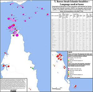
Three languages are spoken on the islands. The two original languages are the Western-Central Torres Strait Language (also called Kalaw Lagaw Ya) and the Eastern Torres Language Meriam Mir.
Yumplatok (also known as Torres Strait Creole) is a modern language spoken in the Torres Strait. It developed from contact with missionaries, traders, and English speakers since the 1800s. It is a mix of Standard Australian English and traditional Indigenous languages. Most Torres Strait Islanders speak it. Each island has its own version of Creole. Torres Strait Creole is also spoken on the Australian mainland in places like Cairns and Townsville.
Climate Change and the Islands
The Torres Strait Islands are at risk from rising sea levels. This is especially true for islands that are less than 1 meter above sea level. Storm surges and high tides are the biggest dangers. Other problems include erosion, damage to homes, and drinking water becoming salty. In 2021, at least one freshwater well had already turned salty.
In early 2020, it was reported that Warraber is very threatened by rising sea levels. Sea walls have been built on many beaches there to protect them. Experts predict that by 2100, tides could rise between 30 and 110 centimetres. This depends on how much carbon emissions are reduced. Several smaller islands are also in danger. Sea walls are being built on Boigu Island, and Masig Island is next.
Torres Strait 8
A group of eight people from the low-lying islands of Boigu, Poruma, Warraber, and Masig are known as the Torres Strait 8. In May 2019, they complained to the UN Human Rights Committee. They said that the Australian government was not doing enough to protect them from climate change. They argued that their human rights were being violated. This complaint was supported by UN experts on human rights and the environment. The group also wants the International Court of Justice to decide if they can get money from countries or large companies for losses caused by climate change.
In 2020, the Torres Strait 8 were named "Human Rights Heroes" in the Australian Human Rights Awards.
In September 2022, the UN Human Rights Committee responded to the Torres Strait 8. It found that Australia had violated two human rights. These rights are "the right to enjoy their culture" and "to be free from arbitrary interferences with their private life, family and home." These rights are part of an international treaty signed by many countries, including Australia. The committee did not find that their right to life had been violated. While there is no way to force Australia to follow this finding, countries usually do. The committee asked the Australian government to pay the Islanders for the harm already done. It also asked them to talk with the community about their needs and take action to keep them safe.
Music of the Torres Strait
The music of the Torres Strait mainly involves singing with instruments. When Christianity arrived in 1871, it had a big impact. But before that, the music showed the different cultures and places within the Strait.
|
See also
 In Spanish: Islas del estrecho de Torres para niños
 | Tommie Smith |
 | Simone Manuel |
 | Shani Davis |
 | Simone Biles |
 | Alice Coachman |


